![]()
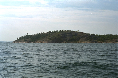 As seen from the water, the 160 foot tall granite rocks of Croker Island's
southern shore present an imposing obstacle.
However, from the inner harbor, it is an easy climb to the top.
In this view we are approaching from the southeast.
Secretary Island is just out of the frame to the left.
As seen from the water, the 160 foot tall granite rocks of Croker Island's
southern shore present an imposing obstacle.
However, from the inner harbor, it is an easy climb to the top.
In this view we are approaching from the southeast.
Secretary Island is just out of the frame to the left.
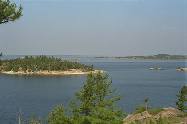 Looking southwest from the top of Croker reveals
Secretary Island, whose white stone shore identifies it easily.
Although the Canadian Coastal Pilot mentions entering via the
gap between the two islands, I have never seen a cruising boat make
that approach. Almost always the entrance to the inner harbour at
Croker is made by going to the west of Secretary Island and north
of those two small islets seen here.
In the background is South Benjamin Island, with some of
"The Boars" and "The Sow and Pigs" visble.
Looking southwest from the top of Croker reveals
Secretary Island, whose white stone shore identifies it easily.
Although the Canadian Coastal Pilot mentions entering via the
gap between the two islands, I have never seen a cruising boat make
that approach. Almost always the entrance to the inner harbour at
Croker is made by going to the west of Secretary Island and north
of those two small islets seen here.
In the background is South Benjamin Island, with some of
"The Boars" and "The Sow and Pigs" visble.
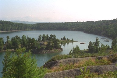 From the top of the southern peak of Croker Island, this spectacular view is seen. Looking northward,
the circular embrace of Croker creates a wonderful harbor. In the distance are
the mainland's LaCloche Mountains.
From the top of the southern peak of Croker Island, this spectacular view is seen. Looking northward,
the circular embrace of Croker creates a wonderful harbor. In the distance are
the mainland's LaCloche Mountains.
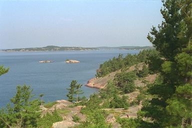 In the distance to the west are North and South Benjamin Islands.
The two rocky islets in the center guard the entrance just north of Secretary Island.
A charted rock with three feet elevation is just awash due to high water.
In the distance to the west are North and South Benjamin Islands.
The two rocky islets in the center guard the entrance just north of Secretary Island.
A charted rock with three feet elevation is just awash due to high water.
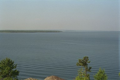 To the south is Clapperton Island, across a calm Clapperton Channel. Robertson Rock lurks in
the distance, marked by a lonely red bouy. Beside it in deep water are wrecks of unlucky
vessels, like the 300-foot steel ore freighter The North Windwhich
was stranded on the rock in 1926 and now lays in 80-100 feet of water.
To the south is Clapperton Island, across a calm Clapperton Channel. Robertson Rock lurks in
the distance, marked by a lonely red bouy. Beside it in deep water are wrecks of unlucky
vessels, like the 300-foot steel ore freighter The North Windwhich
was stranded on the rock in 1926 and now lays in 80-100 feet of water.
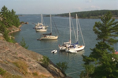 Croker Island is one of the most popular anchorages in the North Channel.
In the inner harbor, boats moor in about ten feet of water, with their bow anchors set
into a clay bottom and stern lines tied ashore.
Of the seven boats seen here, our 30-footer is decidedly smallest--a condition in which we
often find ourselves in North Channel harbours.
Croker Island is one of the most popular anchorages in the North Channel.
In the inner harbor, boats moor in about ten feet of water, with their bow anchors set
into a clay bottom and stern lines tied ashore.
Of the seven boats seen here, our 30-footer is decidedly smallest--a condition in which we
often find ourselves in North Channel harbours.
![]()
![]()
![]()
![]()
![]()
![]()
This article first appeared in 1994.
Copyright © 1994, 1995, 1996, 1997, 1998, 1999 by James W. Hebert. All rights reserved.
This is a verified HTML 4.0 document served to you from continuousWave
URI: http://continuouswave.com
Last modified:
Author: James W. Hebert