![]()
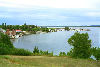
Normally crowded with boats and boaters, the town waterfront is almost empty in late August 1995 while the yacht Chanticleer--owned by the Evinrude family of outboard motor fame--takes up more than 100-feet of the dock. To the west is Boyle Marine, and beyond the bend Spider Bay Marina.
Little Current is located on the northeastern shore of Manitoulin, where the island makes its closest approach to the Ontario mainland. It was first settled in the 1860's and soon grew into a major Great Lakes port. During the 1880's and 1890's, the town's docks were lined with passenger steamers and sumertime visitors from the lower lakes. Besides tourism, lumbering was the mainstay of the economy and remained so until after World War One.
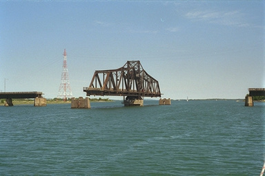
Passage to Manitoulin was only via water until 1913, when a swinging bridge was built for rail use between Little Current and Great La Cloche and Goat Islands, and thence to the Ontario mainland. After World War II, it was converted to enable use by automobiles, and cars and trains shared the bridge. For cars, it is a single lane wide, and runs one-way, alternating directions about every three or four minutes. By the 1980's rail traffic stopped entirely, and today the bridge is used exclusively by automobiles.
Originally, the bridge stayed open until a train was due so as not to impede traffic in the busy waterway. Now the bridge stays closed, allowing continuous automobile access to the island, but during the navigation season the bridge opens for 15 minutes on the hour to allow boats to pass. Both boat and automobile operators need to plan their transit of Little Current if they wish to avoid delays, especially during the peak of tourist and boating season (July and August).
Because the entire east-west flow of water in the North Channel must funnel through this narrows, considerable currents can occur. In particular, when a strong westerly wind blows across the ten-mile-wide open portions of the North Channel eastward from Clapperton Island, water movement is accelerated as it enters the narrowing channel at Little Current. The name "Little Current" becomes rather ironic in those situations, as the current can build to more than six knots.
It is also important to note that the set of the current when flowing from west to east does not usually lie parallel to the foundation piers of the bridge. The current will therefore tend to set you down onto the central span of the bridge as you traverse through on the northern side of the opening, or will set you toward the shore if using the southern side.
On one particular Friday afternoon, we were approaching from the east and in the lee of Manitoulin and La Cloche, quite unaware of the big westerly that had been blowing. The current was running west to east against us as we approached the swinging bridge on the 2 p.m. opening. Since the bridge spans the channel at its most narrow point, the current is the strongest there, as it rips around the bridge's central support pier.
We gunned our engine and headed toward the bridge, making almost six knots indicated through the water. However, the closer we got to the bridge, the faster the current ran against us, and the slower our progress over the bottom. The result was that it was almost impossible for us to get through the narrows. The bridge operator saw our plight, and he kindly left the bridge open a few minutes extra for us. We slowly wore our way past, popping out the other side as the current abated again. The westerly wind increased all afternoon, and I doubt that we could have made it through an hour later, the current having increased in proportion to the stronger wind.
The navigation charts contain this warning:
Excerpt from Chart 2294 7th Edition follows
Caution!
Strong Currents may exist in this area. Vessels should beware of the variable current here, as it changes frequently both in direction and velocity, due to atmospheric conditions, and sometimes runs as much as 7 knots.During times of strong current, buoys may be dragged under water.
The limiting depth through the Little Current passage is about 20 feet, so rather large commercial vessels can transit.
![]()
![]()
![]()
![]()
![]()
![]()
Copyright © 1995, 1996 by James W. Hebert. All rights reserved.
This is a verified HTML 4.0 document served to you from continuousWave
URI: http://continuouswave.com
Last modified:
Author: James W. Hebert