![]()
Louisa Island lies along the northern shore of Lake Huron, just a mile or so off the coast, and NW from LaCloche Island. It is easily approached from the southeast and has a good harbor on its eastern end that will povide shelter as long as the breeze has a predominate westerly component. A shoal to the southeast is marked by a floating aid. Having spotted that mark, take a course well clear to the west of it and proceed north between the two sets of entrance rocks, a single large rock to the west (off the tip of Louisa Is.) and a group of rocks to the east (off Kirkpatrick Is.).
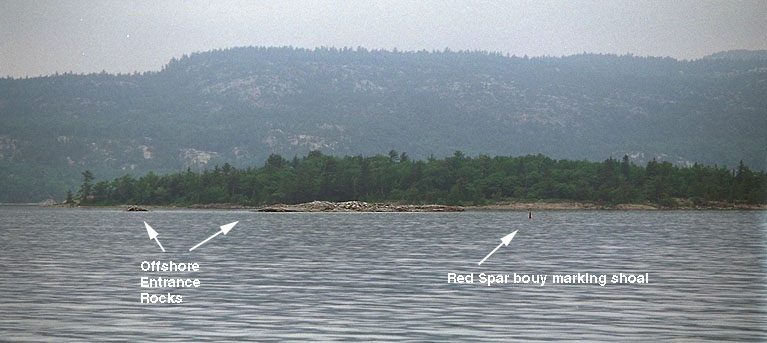 This photo shows the eastern side of the approach. Red spar U4 is
easily seen in the larger photograph. In the background is Kirkpatrick Is., which
lies about a half mile to the east of Louisa Is. A group of large rocks
lie against the island background, making them a little harder to see in this
picture, but once you get a little closer, they are very visible.
This photo shows the eastern side of the approach. Red spar U4 is
easily seen in the larger photograph. In the background is Kirkpatrick Is., which
lies about a half mile to the east of Louisa Is. A group of large rocks
lie against the island background, making them a little harder to see in this
picture, but once you get a little closer, they are very visible.
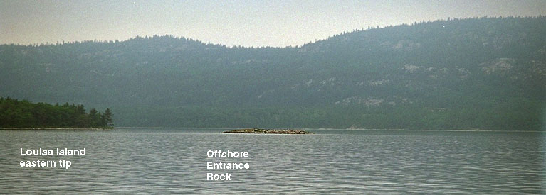
This photo shows the western half of the entrance, with a single large rock that lies off from the eastern tip of Louisa Island, showing here against the open water to the north.
Soundings on old chart No. 2286 don't provide too much data, but there seems to be no hazards once you clear these twin entrace rocks. (The term "entrance rocks" is used rather frequently in describing harbors in the North Channel; they all seem to have a few rocks at their entrance, some of which serve to mark the entrance, and others which make things more interesting.) Make a gentle turn to the west when abeam the harbor on the eastern side of Louisa. You should find good water all the way into the anchorage.
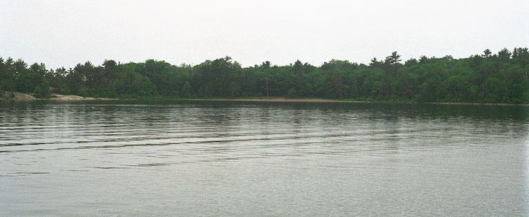 The harbor bottom looks like sand, but we did see a few large logs scattered around,
so watch where you drop your anchor.
As the breeze increased from the southwest, we found a little flaw in our anchorage.
The island itself provided a nice break from the winds, but waves,
which were running three feet or more in the North Channel,
bent around the SE tip of the island and came
rolling into the anchorage as tiny swells that were just large enough to rock the
boat as it lay broadside to them. You can see them clearly in the larger
image of this photograph. And, yes, that is a sandy beach in the center of
the harbor, although there are some small rocks just offshore that make
the swimming a little hard on the feet the first few yards from the
shoreline.
The harbor bottom looks like sand, but we did see a few large logs scattered around,
so watch where you drop your anchor.
As the breeze increased from the southwest, we found a little flaw in our anchorage.
The island itself provided a nice break from the winds, but waves,
which were running three feet or more in the North Channel,
bent around the SE tip of the island and came
rolling into the anchorage as tiny swells that were just large enough to rock the
boat as it lay broadside to them. You can see them clearly in the larger
image of this photograph. And, yes, that is a sandy beach in the center of
the harbor, although there are some small rocks just offshore that make
the swimming a little hard on the feet the first few yards from the
shoreline.
Explorations ashore were limited to the beach, so I can't report on anything about the interior of the island. A friend reported terrific smallmouth bass fishing here, although we've heard that about almost every anchorage at one time or another. The best fishing was usually "yesterday."
![]()
![]()
![]()
![]()
![]()
![]()
Copyright © 1996, 1999 by James W. Hebert. All rights reserved.
This is a verified HTML 4.0 document served to you from continuousWave
URI: http://continuouswave.com
Last modified:
Author: James W. Hebert