![]()
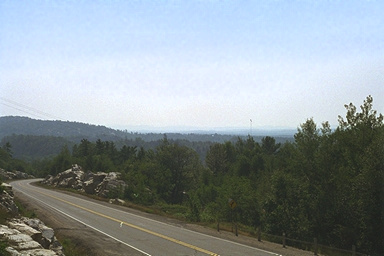
The La Cloche Mountains form the north shore of Lake Huron and the North Channel. This view is from near the summit of the Highway-6 route southward from Espanola, looking south toward Manitoulin, which can be seen in the haze in the distance.
You might be wondering why I don't have photographs of the "shore" of the North Shore. There is a good reason for that: we've never sailed too close to the north shore. That is because most of the shoreline is very poorly charted and lacks sounding data. The last survey of some areas was made in 1822! That is not a typo: Eighteen hundred twenty-two!. The most recent published survey was conducted in 1885. To make navigation more difficult, the existing chart (2286) is issued with soundings in fathoms and depths referenced to an out-of-date low water datum.
For several years in the early 1990's, survey vessels of the Canandian government were in the area and made a thorough hydrologic survey. Finally, in 1997 a new chart (2206) was issued for McGregor Bay, albeit in a somewhat unusual format. The chart was printed on both side of the paper, but can be cut into three segments, each with an intact chart on either side. This works well, allowing you to cut the chart into thirds. Unfortunately, however, the soundings have been converted to metric measurements. This, in my mind, renders the chart decidedly user-unfriendly!
When navigating in this area, you must use three different charts with three different representations of the depth: fathoms, feet, and now meters.
Bay of Island awaits its new chart publication still.
![]()
![]()
![]()
![]()
![]()
This article first appeared in 1996.
Copyright © 1996, 1997, 1998, 1999 by James W. Hebert. All rights reserved.
This is a verified HTML 4.0 document served to you from continuousWave
URI: http://continuouswave.com
Last modified:
Author: James W. Hebert