We thought it might not be hot enough in early June for small-boat recreation up north. So we planned on heading south instead.
The first week in June can be, weatherwise, rather unpredictable for northern Lake Huron. It can be about the coldest place you've ever felt in June, like it was for us in 1986. Or, you can have a heat wave, like we are having this year.
Because our vacation schedule demands we take our "summer" trip early in June, we decided to forego our traditional visit "up-North," and instead we are going south (from Birmingham, Michigan) to Kentucky Lake, Kentucky. This is new territory for us both, as neither my wife, Chris, or I have ever been to this part of the country.
On Thursday night as I get the forecast off the web for western Kentucky, I can't help but notice that Sault Ste. Marie, Ontario is expecting temperatures in the 90's tomorrow! So much for cool weather up north. Of course, the water will still be in the 40's, if that is any solace.
With the usual preparations to boat, motor, trailer, and car, we are ready to leave, taking off on Friday so we can split the drive into two segments. We'll get 80% of the way to the resort on Friday, then stay in a plain motel along the highway, which will be quite a bit cheaper than the $140/night we're paying on the lake. Then, when we get to the lake on Saturday, we can arrive before lunch time, and have most of the day to enjoy ourselves.
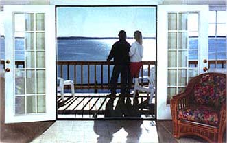
While I have been busy working on the boat, Chris, as always, has made all the travel arrangements. Using her travel intuition and ability to read between the lines of promotional brochures, augmented with plenty of research on the web, she has picked one resort from all the dozens on Kentucky Lake: Lighthouse Landing.
|
| When Chris found this view on the internet she was sold on Lighthouse Landing |
The driving is pretty simple: take Interstate-75 south. We cross the whole of Ohio. I don't think they have a single lake in the state! No wonder we see so many Ohio registered boats on lakes in northern Michigan. From Dayton to Cincinnati it seems to be one giant megalopolis. Across the Ohio River into Kentucky we go. Now the terrain changes; from the river southward, it is uphill for many miles.
Frankfort, Kentucky, the capital of the state, is our planned first night's stop. Making our way slowly into the center of town in five-o'clock-Friday-rush-hour traffic, I begin to wonder if this is the right place. When we find our motel, there are two obvious problems: first, the entire parking lot of the place is built an a hill; there isn't an inch of level ground to park the boat trailer. (Chris has a plan that calls for us to leave the trailer at the motel while we go downtown to a festival.) And second, the entire parking lot is empty. The motel has several hundred units, but we look like its only guest. This sets off an alarm for me. The name of the place has been hastily changed with a crudely painted sign. No thanks, we won't be staying here. We're ditching Frankfort completely; after the heat, the highway construction, and the oddly empty motel, we decide to leave downtown Frankfort unexplored.
We get back on the highway and continue in the direction of Kentucky Lake. About an hour farther along the road, we pull up to a stately looking motel in Bardstown. Chris hops out to check the prices, and she returns with a smile.
"We are staying here," she says, showing me the room key. "It is only fifty bucks a night--'pre-season' rate."
That sounds good to me, plus the parking lot is on level ground and they have a swimming pool. We have already grabbed a quick meal on the road, so we don't need to go out for dinner. The swim in the pool takes the heat out of the day, and the color television in the air-conditioned room gives me a good picture for Game Three of the Stanley Cup Finals.
We leave the sleepy hamlet of Bardstown on a quiet Saturday morning and head west on the Blue Ridge Parkway. This is a great road, rolling up and down the tree covered hills of central Kentucky, and we have it practically to ourselves. It seems we left all the big trucks back on the Interstate.
By 11:00 a.m. we are almost at our destination, and getting hungry. Chris spots The Pelican Restaurant, whose cuisine is highly regarded according to the brochures we have. We pull in for breakfast. It's a little different than the brochures. I can't remember exactly how they described it, but here in Michigan we'd say it was a smokey truckstop kinda place. A little too smokey for us, but we are too hungry to turn back.
"How y'all doing this mornin'," asks the waitress. After we order she asks, "Where y'all from?" I guess our accent stands out down here. The food is good, but almost everyone in the restaurant is smoking. It is a trend that will continue.
Back in the car and only a few minutes from our destination, Chris and I laugh about how the brochure over sold the restaurant. It was fine, but not quite what we imagined from the fancy prose of the travel guide. Will our accommodations on Kentucky Lake live up to their billing?
Just after noon, we pull into Lighthouse Landing. It is hard to miss their marina full of sailboat masts. There are over a hundred boats in the water in slips and a few dozen more lined up along the shore in cradles. Chris handles the check-in at the office. We are a little early, but they are glad to see us and the cabin is ready for us to move in.
The Mint Cabin, as the resort calls it, is up on a hill, so we need to launch the boat and disconnect the trailer before we drive up there. The boat needs some gas--Lighthouse Landing does not have a gas dock-- so we head back to the highway to fill up. Finding a gas station takes us almost back to the interstate, but we eventually top off both the 12-gallon and 6-gallon fuel tanks. Now we are ready to launch.
Lighthouse Landing has a boat ramp, as well as a Marine Travel-Lift and a haulout slip. But the ramp is a little different from those we are used to in Michigan. It is a paved ramp, but there is no courtesy dock along side. It's just like a little strip of highway that disappears into the water. We've never seen one like it before. We study the situation, and watch another boater launch from the ramp to take a lesson from him.
It looks like the launch strategy is a two-man affair. One guy gets in the boat, while a companion in the car backs it down the ramp. Once the outboard motor lower unit is in the water, they start the engine and back the boat off the trailer. Interesting, but we've never done it that way, as I am usually the one driving the car and driving the boat. Chris is not too comfortable taking on either one of these new roles. Also, we want to be really careful in launching, since having a working boat is fundamental to enjoying this whole week. Probably 95% of the damage to trailerable boats occurs during either the launch from or recovery to the trailer, so we are being extra cautious.
We think for a minute about finding another ramp, but a check with one of the locals tells us that this is about as nice a ramp as there is around here. Okay, we'll go for it. I tilt the motor up so there is no chance of banging the skeg when she slides off the trailer. With neither of us aboard, we shove the boat off the trailer and into Kentucky Lake. Chris retrieves the boat and hangs on to the bow, while I go park the car and trailer. Then I climb in and get the engine started.
All is going well; the engine starts and we are in the water without incident. I motor the boat along side a floating dock next to the haulout slip, and Chris and I load all the rest of the gear aboard. Then we take a short trip over to the slip we've rented for the week (for a modest $35) and put the boat to rest for a while.
Now it is time to see our accommodations. It certainly looked wonderful in the brochures and on the internet. Will it be as good in person? We drive up the winding little road to The Mint Cabin, which is perched on a bluff about one hundred feet above the lake. This road was made for Sport-Utility vehicles, not for long low sedans, but we get the Crown Vic up there without bottoming out.
Unlike Frankfort, unlike the first motel, and unlike the Pelican Restaurant, The Mint Cabin is exactly like the photographs and the prose. It is wonderful. It's clean, light, airy, looks brand-new, and best of all, air-conditioned. I should mention that it is now about 1:30 p.m. and the temperature is close to 95-degrees. We have been wrestling with the boat, its gear, and our luggage, and we are hot. When we turn the A/C on in the cabin, cool dry air floods the room. It is wonderful. Staying here for a week will be no problem!
Once we have everything unloaded from the car and stored in the cabin, we are ready for a cruise on Kentucky Lake. The lake is really the Tennessee River, dammed up by a big hydro-electric dam about half of a mile north of here. The water has backed up and filled the valley for a hundred miles or more to the south, creating Kentucky Lake, which averages more than a mile in width and about 60 feet in depth in the main channel. Right in front of the beach at our place we see large river towboats and huge strings of barges going by, so we know there is some deep water out there. All the six-foot-draft sailboats in the marina are testimony to the depth of the channel leading into Lighthouse Landing. We are not immediately concerned about getting a chart of the lake; we'll just go for a quick boat ride.
As we enter the lake by mid-afternoon there is quite a breeze blowing in from the south. With miles and miles of lake in its fetch, it has built up some pretty good waves here at the northern end, and the lake is a little rougher than we anticipated.
![[Photo: Towboat in lock]](images/towBoat.jpeg) |
| City of Lexington locking upstream at Kentucky Dam Lock |
Our first attraction is the collection of barges and towboats assembled to the north, awaiting an opportunity to lock through the dam and continue downstream on the Tennessee River. We've not seen this type of workboat in person before, and they are interesting craft. Some are well over one hundred feet long, yet they all have just a foot or two of freeboard. Big swells and breaking waves must not be a concern for them.
Going back south and against the waves, the lake is even rougher. We take the man-made canal into adjacent Lake Barkley, whose waters should be calmer in the lee of the tall ridge that divides the two lakes.
Lake Barkley is similarly formed by a large hydro-electric dam on the Cumberland River. The more recent digging of the canal between the two bodies of water has equalized their water levels. Lake Barkley is not as wide as Kentucky Lake, being less than a mile in width for most of its length. We cruise northward towards the dam, and turn in at Green Turtle Bay Marina, a site familiar to Chris from her internet research. After a spin around the marina, we head back to our home port.
When we get back to the cabin, it is like an igloo inside. Chris left the thermostat set at 65-degrees. "I wanted it cool when we got back," she says. It is so cold in the cabin that moisture is starting to condense on the windows! But it is welcome relief from the heat outside. Off of the boat and back on land, the heat is intense. It must be in the mid-90's today. We take a nap before dinner to rest up.
Again Chris is armed with local knowledge of the restaurants, and she wants to eat at Patti's Settlement in Grand Rivers, right across the highway from us. As we drive across the road--it's still too hot to walk--we realize that everyone else in the area wants to eat there, too. It is Saturday night, and the place is packed. They are booked full with reservations, but they suggest we try their sister restaurant, just down the street, The Iron Kettle.
We grab the last spot in The Iron Kettle's parking lot, and get seated for dinner without delay. The waitress explains that tonight is a buffet, $11 per person, and we can help ourselves. "Would you like something to drink?," she asks.
"Do you mean 'something to drink' like from the bar?", I ask her back. She gives me a strange look, and explains that the choices are soda, iced tea, or lemonade. We have just discovered one little fact that all the promotional brochures have over looked: this is a "dry" county. There is no alcohol sold, in restaurants or stores!
Even without a beer, dinner is great. There are five or six kinds of meats and chicken, innumerable potatoes and vegetables, tables of breads and desserts, and everything is delicious.
We return to the cabin very well fed. The heat lingers on into the evening, so we withdraw to our air-conditioned environment. There is a nice color television set with a cable feed. After checking out tomorrow's weather on The Weather Channel, we watch a good movie, Coal Miner's Daughter, ironically about a singer from the coal mining region of Kentucky, not far away.
The morning dawns with clear weather, but the heat wave continues. We start boating early, with a morning cruise down the western shore of Kentucky Lake. Directly in front of our marina a large houseboat is anchored. It has a minister on board and he is conducting "Blessing of the Fleet" ceremonies. We motor slowly over to the big boat, and our little Boston Whaler receives the blessing.
With the wind out of the southwest, the western shore will be the calmer side of the lake today. There is a great deal of development along here, unlike the eastern shore which is part of the Land Between The Lakes National Recreation Area. We motor slowly along, surveying all the homes and cottages from the comfort of the shade under our new bimini top. Cruising down here would be impossible without it. Just about all the sailboats in the marina have one, yet strangely most of the local bass boats we see do not.
After a couple of hours, we are southward along the shore to Moors Resort, where we stop for some gas. Chris checks out the cabins available here. "I saw these on the net, too," she says. They are nice cabins, but they can't duplicate our terrific setting overlooking the lake from the bluff back at The Mint Cabin.
We have lunch aboard, our usual boat meal of peanut butter and jelly sandwiches, which I wash down with some Canadian beer that I brought with us. Bringing that beer was a pretty good idea. Originally I did it so we'd have some Labatts or Molsons on hand should it not be available locally. I didn't know that there wouldn't be any beer available locally. We cruise back along the eastern shore, pulling into one of the larger bays that has a bathing beach where we take a refreshing swim.
By early afternoon we are finished with the cruise and back at Lighthouse Landing. We are not acclimatized to these temperatures, and once we get off the boat, we a driven by the heat on the land into the cabin for a nap.
By late afternoon the skies are growing dark, and it looks like some of the energy they have been building up for the past three days is going to be shed in a thunderstorm. Up on our bluff, the winds are really howling, having veered to the northwest. I get concerned about the boat--we left the bimini top up and the top's maker said it was only rated for about 25 mph--so I make a quick trip down to the marina to see how it's doing.
Back at ground level, the wind is not as intense as it was on our one-hundred-foot-high perch above the lake, but it is still blowing quite hard. Suddenly a big gust hits, and just at that moment a towboat is right in front of the marina with a string of empty barges. The wind blows the barges out of the channel, and the towboat is forced to go into hard reverse with its stern to the wind. She lets the barges swing downwind and holds them off the marina entrance with plenty of stern thrust, churning the water brown underneath her. It makes for quite an interesting half hour while the tow and barges fight the gusting winds right in front of us.
After this drama ends and the thunderstorms subside we go off in the car in search of Kattawa, a town on Lake Barkley to the east, where we have dinner at Rudy's Restaurant at the marina, famous for their RudyBurgers. The burgers are huge. The formica tables are out of the 1950's.
Monday morning begins with the remnants of an overnight rain. When the rain passes, I get down to the boat to see how much water is aboard. There are several inches in the cockpit, which I bail with a bucket. Looking at how the boat is riding, I decide to test a theory. I pull the drain plug from the little sump at the rear of the cockpit, and step back off the boat; water starts going out the drain instead of coming in! This is great. I should have probably left the drain plug open and all the rain would have drained out as it came in. Without any passengers aboard, the Whaler sits high enough in the water to keep the waterline below the level of the cockpit floor, containing all the water in the little sump.
After the boat is shipshape, we take off on another morning cruise, this time heading down the canal and into Lake Barkley, going toward Old Kattawa where we ate last night. After the busy weekend, we see few other pleasure boaters, and just the occasional barge and towboat.
Again, lunch is on board, under the bimini, and it consists of the usual PB&J sandwiches, washed down with Molsons. We make it upstream as far as the Kattawa Marina, where it is time for six more gallons of gas. We also pick up some charts at the marina store.
In the marina store they have a bucket over in the corner with a dozen or so rolls of rolled up chart segments of the river. The charts are issued by the Army Corps of Engineers, and they are only $2 a sheet. We've seen some other locally produced charts, but they are more in the "Fishing Map" style, and are quite a bit more expensive.
As I go to the register to pay for the charts, the marina fellow mentions the other charts to me. "We've got these other charts here of the Lake," he says. "They may be better for you."
"Naw," I tell him, "I like the 'official' charts."
He gives a laugh as he replies, "I don't know what is official about those. Look at the last revision date."
The Corps of Engineer charts are a little old. They haven't been updated in twenty-three years (1976). They also contain another oddity. The lake levels don't show water depths, they show bottom elevation! This is a unique chart presentation, at least in my experience. Since the water level is subject to some variation and perhaps some control by the dams, the charts show the elevation of the bottom contour and you then deduce the water depth by subtracting that from the present lake level. It is a rather backward process for the mariner.
![[Chart: Kentucky Lake]](images/chart1-small.jpeg) |
| Army Corps of Engineers Chart Larger Image |
For example, the lake is currently at its "Summer Pool" level of 359 feet elevation (above sea level). So on the chart, where ever I see a bottom contour of 354 feet, I know I should have five feet of water. It takes a little getting used to. On the non-official fishing charts, the chart publisher has done all the math for you, and shows the depths in feet, referenced to a water level of 359 feet. Maybe they were a better choice, I conclude.
Back in the boat, now topped off with gas and carrying "official" charts, we continue upstream, passing a rather interesting landmark on the eastern shore. It is the Kentucky State Prison! When it was originally built in the 1800's, its tall castle-like stone towers didn't overlook Lake Barkley. The Lake showed up about a hundred years later. The hilltop prison now resides on the shore of the lake. It seems like an extra cruel punishment for the incarcerated inmates to have to sit in a hot prison cell on a beautiful summer day like this and watch all the boats out on Lake Barkely.
As the heat of the day really comes, we return to Lighthouse Landing, dock the boat, and retreat to the comfort of the cabin. After an afternoon nap--we are really having a lazy vacation--we drive up to Paducah for dinner.
![[Makers Mark bourbon bottle]](graphics/makersMark.gif) It's about 25 minutes on the interstate to reach Paducah.
At the city limits a strange phenomena occurs: there is alcohol for sale!
As soon as you cross the line,
both sides of the highway are taken over with huge liquor stores.
"Booze World" proclaims one sign.
We pull in to shop.
The store offers about 200 varieties of bourbon, most bottled in surrounding Kentucky or Tennessee,
plus a big selection of just about every other kind of whiskey, wine, or beer.
We augment our supply of intoxicants by buying some Makers Mark bourbon,
a brand recommended to us by a friend.
It's about 25 minutes on the interstate to reach Paducah.
At the city limits a strange phenomena occurs: there is alcohol for sale!
As soon as you cross the line,
both sides of the highway are taken over with huge liquor stores.
"Booze World" proclaims one sign.
We pull in to shop.
The store offers about 200 varieties of bourbon, most bottled in surrounding Kentucky or Tennessee,
plus a big selection of just about every other kind of whiskey, wine, or beer.
We augment our supply of intoxicants by buying some Makers Mark bourbon,
a brand recommended to us by a friend.
We continue on to downtown Paducah, where we have dinner at the Whalers Catch restaurant. Whaling is an odd motif for a restaurant located along the Ohio River, we think, but it does have a seafood orientation and an interesting decor. The menu is more New Orleans, in contrast to the New England name, and we have some shrimp creole for dinner. We get a second floor window table, where we can overlook the river traffic as we eat. The food is good, but a little pricey.
After dinner we walk down to the river. The banks are paved over in concrete, sloping right into the water, and they also function as one giant boat launch ramp. Just behind the river on the Paducah side the city has constructed a tall and sturdy brick and concrete wall. It is a dike, which encircles the city, and it is intended to keep the river out of Paducah during the spring floods.
Paducah is located on the Ohio River, just downstream of the outlets of both the Tennessee River and the Cumberland River. And just downstream of Paducah is the Mississippi River, itself rather likely to be swollen with flood waters in spring and reluctant to accept more. Thus, you might say that Paducah is on fertile ground for flooding. All that spring water has to go someplace, and in the past, without the control of the dams on the Tennessee and Cumberland, it tended to go right into Paducah. The water has crested here as high as 50 feet above the normal level, flooding the downtown completely and extending inland for miles.
Now, with the dams and the dikes, Paducah keeps all that water in the river, sending it downstream to flood somebody else in the spring.
In the downtown the city has nicely restored several older warehouse buildings, converting them to retail and restaurant use. And along the dike it's in the process of decorating the big walls with murals. We watch as several artists are at work creating a huge panel.
"Paducah has more historical monuments than any other city in Kentucky," Chris reads from the guidebook. We laugh as we see that almost every block downtown has an historical marker, announcing that "This used to be the site of...." I guess it was hard to keep those old buildings going with all the floods.
On the way out of town we do some more shopping for groceries and a spare fan belt for the car. The car A/C is getting a workout down here, and I am suddenly worried about the drive belt that has 98,000 miles on it. If I have a spare in the trunk, the original will run for another 100,000 miles, I know.
On the way back to Lighthouse Landing, we stop at Kentucky Dam to watch the activity at the lock. The temperature has finally gone down after sunset, and it is a beautiful evening. We park close to the lock and walk up to see a large tow coming though.
The lock has a width of 110 feet and a length of 600 feet. The Tennessee River below the dam has a normal elevation of 302 feet, making the lock a 57-foot drop from lake to river. When it was finished in 1944 the lock was probably seen as sufficiently large for barge traffic at the time. Now is it something of a bottle neck.
In 1999 the typical river towboat configuration consists of barges that are 35-feet wide and just under 200-feet long, which are lashed together in a three-by-five arrangement to which the towboat firmly lashes itself at its bow. The boat pushes the barges along even though they call it a "tow." Altogether, the barges and towboat form a composite vessel about 1,150 feet long and 105 feet wide.
When the tow encounters a lock like the Barkley Dam, it has to be split up to transit. The usual procedure is to detach and shove the first three rows of barges into the lock. The 105-by-600 combo of barges just fits in the 110-by-600 lock. The towboat then backs out of the lock with the other two rows of barges.
Next, the lock doors close and the nine barges are lowered. In normal operation, there are some hydraulic mules built into the lock that then pull the nine barge tow out of the lock and hold it against some mooring "cells" (which are huge concrete reinforced pilings).
Then the lock is reflooded--it takes a lot of water to do this since we are talking about a volume of 105 X 600 X 57 = 3.5 million cubic feet of water. That's enough water to cover 83 acres to a depth of one foot. When the lock has filled back to the level of the lake, the upstream door is opened and the tow enters with the remaining six barges.
This barge/tow combo is 105-by-550 feet so it fits comfortably in the 110-by-600 lock this time. The lock closes and lowers the second half of the tow to river level, where it exits and makes up with the rest of the barges waiting at the mooring cell.
Tonight there is a little snag in the works. The hydraulic mules are out of service. This means that handling the first group of barges must be done by another towboat, stationed above and below the lock as appropriate to the direction the tow is locking through. This actually works in our favor, as there is a smaller towboat, captain, and crew, hanging around the lock all night, waiting to assist. We get a chance to yack with the master of the helper towboat. He's a guy in this 30's, but he's had plenty of experience in towboats. And he enjoys his life on the river. From the tall pilothouse of the towboat, he is just about face-to-face with us.
"I've got about the best job in the world," he tells us proudly, as we lean over the railing at the lock to talk to him. I ask him if this is his regular job.
"Naw," he says as he explains to us the trouble with the hydraulic mules, "they've got a problem here at the lock and we're just helping them out. On the river we lookout for each other."
It is really a wonderful night, with the air warm and filled with a mixture of smells--river, diesel, fish, and woods mingled together. The sound of lapping water and banging barges in the lock is slowly replaced with a distant low throbbing.
A loaded coal train is approaching from the west, climbing the grade to the crest at the dam where a single track carries across in parallel with the highway. On level ground we've seen many trains, but their locomotives were not straining to a purpose like the four at the head of this one. With a hundred hopper cars loaded with coal behind them, the big road diesels are using all of their 4,000 horsepower (each) to haul this drag up the hill. The sound is wonderful, unlike anything you can hear in Michigan. Sixteen thousand horsepower of diesel engine rumble up the grade and across the dam. Although we are surrounded by millions of cubic yards of reinforced concrete, it almost feels like there is a vibration under our feet.
"Let's go back to the cabin and have some of the bourbon we just bought," I say to Chris. That will make a real Kentucky nightcap to this fine evening.
Tuesday is another sleepy dusty delta day, as the song says. We get up in the morning and have coffee on the nice deck in front of the cabin, which affords a great view of the lake to the west and south. There is almost always a big tow boat coming or going to provide some entertainment. It is so hot already that there is a haze hanging across the lake and the opposite shoreline is a little obscured and hard to see. It's like that almost every morning this week. Had I brought the camera with me (I didn't), my pictures wouldn't have that crystal clear blue sky look to them.
We start off our morning boating with a high speed run down the west side of the lake to Moors Resort, where we left off on Sunday. We keep the bimini folded up, since we are able to get a couple of knots more speed without its wind resistance, and it also avoids stressing the top and frame in the high winds. The lake is really calm this morning, and we are running very smoothly.
After 30 minutes or so, we resume our slow cruise, this time our navigation augmented with charts of the water and land. On the western side of Kentucky Lake there is a secondary shipping channel, marked with floating aids and daymarks, providing about ten feet of water minimum in mid-channel. At Jonathan Creek, we venture inland, crossing under the main highway bridge.
Adjacent to the bridge there are half a dozen boats fishing; it must be something of a hot spot. As we motor slowly through the fishing fleet to pass under the bridge, Chris points out the high-water marks on the concrete bridge support columns to which the locals have added annotations of the year and height above normal. These are rather interesting marks to see. About 15 years earlier, the spring high water reached more than 25 feet above the current lake level. That is a huge amount of extra water! It must have stretched the shores of the lake inland for quite a distance. With the water levels subject to such variation, we begin to understand why the launching ramps don't have courtesy docks; they might be underwater half the time in spring.
Jonathan Creek goes on for quite a way, but we leave most of it unexplored. We pull in to Sportsmans Lodge for some gas, where we get some nice complements on the Boston Whaler as we top off our tanks. We haven't seen another Whaler down here. The popular local boat is the bass boat, preferably with a dark metallic color hull and a 200 (or more) horsepower outboard. A four blade stainless steel prop is a must.
The resort looks like a good place to stay if you are interested in doing a lot of fishing. We walk up the hill to take a peek at the cabins. They are nice, but The Mint Cabin, with its high perch overlooking the lake, has spoiled us.
Back out in the lake we have in sight the big Eggner Ferry bridge which carries Highways 68 and 80 about a mile across the water with help from a causeway, several concrete piers, and lots of cantilevered steel. This is about 25 miles south from Kentucky Dam, and it will mark the southern limit of our explorations, both by boat and by car.
On exiting from Jonathan Creek, we turn North-by-East and make a high speed dash across the lake, heading for the eastern shore and Land Between The Lakes (LBL) . On a weekday like this we pretty much have the lake to ourselves, although we do encounter, ironically, a Sheriff's Patrol boat, but it doesn't take any action to hail us for a boarding or inspection. We just get a wave from the two officers aboard.
We cruise lazily northward along the LBL shoreline, ducking into one of the large inlets where we go ashore for a swim. The water is not the clearest we've ever seen, but on a hot day like this it is very refreshing to take a dip.
By mid-afternoon we are back in the cabin asleep. That night we revisit the Iron Kettle for dinner, finding the mid-week buffet price lower as they have less meats available. We opt for even cheaper than that, ordering just the salad portion and making a meal of it for only four dollars per person.
This night we take an evening cruise in the boat, getting a chance to try out the running lights for almost the first time. We explore along the northern limit of the lake, poking around the Kentucky Lake State Park Marina inlet. It is just too dark to see what we are doing, so we return to water we know better, heading back to Lighthouse Landing. It's Game Four of the Stanley Cup tonight.
Wednesday it seems even hotter than it has been, so it must be in the upper 90's. The morning cruise takes us back to Kentucky Dam Village State Resort Park Marina and Lodge(s). Besides their own airstrip, golf course, tennis courts, cottages, convention center, pools and beaches, they also must have 400-500 boats under covered slips at the marina, which is inside a rather elaborate breakwall to eliminate any wave action from the lake. The boats range is size from 16-foot bass boats to 60-foot sportfisherman. It looks too huge and well managed an operation to be run by a government agency. We find out that the village is operated by a concessionaire. That might explain it.
Despite six days exposure to the heat, we are still not comfortable in it and the hot muggy weather drives us indoors again. Chris is absorbed by a good book. I get bored and wander back to the marina to fiddle with the boat. I go out alone for a high-speed test run. With the lake calm, the bimini down, and just me in the boat, we hit a top speed of 36 MPH at 5500 RPM, indicated by my new GPS. Not bad for a 23-year old motor. It is turning my new Black Max 10.125" X 15" three blade (cupped blades) prop.
We start out early for dinner in the well air-conditioned car, cruising by highway down the center of The Land Between The Lakes. Using the Corps of Engineer Lake Charts to navigate on land--they show more detail than any of the park or highway maps we have--we explore some rather remote parts of the park. We are heading for what the charts show is a smaller secondary dam, when Chris interjects.
"Hey, I saw an animal standing in the middle of that side road back there," she exclaims. I am not paying too much attention because I've just come to a roadblock. I guess they don't want the tourists going down to that dam, after all. We back up the road and turn down the little side road where Chris saw something.
Wow! Right in front of us in the middle of the road in the shade of a big tree stands a large black or dark brown cat. By large I mean one-hundred pounds large. The wild animal looks up at our car, with a very cat-like movement leaps up and over whatever it was investigating in the road, and with one big bound disappears into the forest and brush.
"What was that?", we both ask aloud. Eventually, we decide we have just seen a bobcat or wildcat, as in the mascot for the University of Kentucky (Wildcats). This makes the two deer we have already seen pale in comparison. There is a lot of wildlife in this Land Between The Lakes.
We get back to the main highway and continue southward through the park, crossing west on the Eggner Ferry Bridge, and continuing north up the western side of the lakeshore, stopping at Catfish Kitchen for dinner, a place recommended to us as the best place around to sample the local staple, fried catfish.
It has grown rather late by the time we finally pull into the parking lot at the restaurant and I am a little too hungry and a little too tired to completely enjoy my dinner, but the food is excellent nevertheless. We have a nice meal of fried catfish, fritters, cole slaw, potatoes, vegetables, and dessert. I think there is a salad in there, too. I am not sure I would give up Salmon en Papillote for fried catfish, but I can recommend Catfish Kitchen as your best bet in the Kentucky Lake region for catfish.
On Thursday the heat wave abates just a bit, or maybe we are finally getting used to it. We have seen Kentucky Lake for the last few days, so we return to Lake Barkley for a cruise. This time we get beyond Old Kattawa, and adventure all the way to Eddy Creek, where we find a very nice marina and resort.
We pull in for gas and a stretch of our legs. The very polite dockboy tops off our tanks. I have run out of oil, but I see the marina sells it at the dock for less than I can buy it in the SUPER K-MART in Michigan. I add a couple of pints to the bill. It is one thing that is definitely cheaper down here.
The marina has a very nice restaurant, Echo Charlie's, overlooking the docks and the bay. We are tempted to eat lunch here, but I propose to Chris that we eat the Peanut Butter and Jelly sandwiches we brought and drive back here tonight for dinner. She agrees.
We have reached our southern limit on Lake Barkley; as the heat of the afternoon is coming on we cruise back toward the north at moderate speed, returning in time for our afternoon nap in the cabin.
That evening we drive back for a pleasant dinner at Echo Charlie's (restaurant), and after dinner we take our usual stroll along the marina docks, gazing at the various boats, looking as always for the one that most suits our needs, aesthetic, and budgets. The docks at the Eddy Creek Resort are without question the nicest around. They look so clean they must be brand new. The tennant boaters have decorated their slips with carpets, chairs, planters, and other touches of home, and birds fly and sing under the bright white roofs overhead. It is really an excellent facility. They have a nice sandy beach nearby, although no one seems to be in swimming. It certainly is hot enough for it again tonight.
Friday, our last full day at Kentucky Lake, we have another 20 mile cruise planned, but we run into a snag. When we get down to the boat in the morning, the engine won't start. The problem is the battery! It just does not have enough energy stored in it to crank the 4-cylinder over. Usually the motor starts at the turn of the key, with very little cranking, but this morning it won't even turn over. I get my Fluke Digital Multimeter out of the car trunk. The battery voltage is down to 12.2 volts, or in other words, rather discharged.
The good folks at Lighthouse Landing come to our rescue by lending me a battery charger. Ironically, it is exactly like the one I have (left) at home. "The battery charger," I think to myself, "one more thing to bring with you when you go boating."
Armed with the multimeter and a thick factory service manual with complete schematic diagrams that I did bring along, I come to the conclusion that the alternator diodes are shot. They have blown in such a way that the tachometer is still working--often if the diodes are bad the tach stops working too--but there is absolutely zilch charging of the battery from the engine. I begin to speculate that the motor could have been in this condition for some time, since the battery is quite new, it starts so easily, and I frequently have topped off the battery on the charger before we go boating for an extended period like this. In any case, the diode assembly is kaput and needs replacement. We settle for two hours of charging the battery (with the battery charger), which gets enough energy into storage to be able to start the engine again. The formerly-faithful fifty horse outboard comes back to life Since we have plenty of charge and only likely need a start or two more during our cruise, we are safe to go boating. Then we have a new problem.
We get out of the marina and on the lake around noon, in time to look to the right and see a tower of big black clouds heading up from the south. The breeze has a new coolness to it and there is a new smell of rain in the air. And to make things worse, the northern end of the lake has quite a nasty chop on it now, pushed along in front of this storm. We assess our situation: we've got a shaky battery, there is an obvious storm coming, it is rough going to windward, and we've already explored both lakes for 25 miles down from here. Okay, we turn around and head back for the marina.
"I'll tell you what," I say to Chris, "Why don't we just go haul the boat out right now so we don't have to do it later this afternoon in the rain?" That suits her, so we abort our final day of cruising and head for the boat ramp.
There is no one else around for the ramp, so I back the trailer in while Chris gets the boat from the boat slip. Trying this for the first time, she more or less drives the boat onto the trailer, on which I stand waiting to attach the trailer's winch line. It works out fine and we have the boat out of the water in just a minute. A few minutes more and we have the gear all stowed in the car trunk and the cover on the boat. The first drops of rain hit just as we back the trailer into a parking spot with the other boats on the hard. "Great timing," I am thinking to myself. There is only one problem.
The big ugly dark clouds and rain roll through northern Kentucky Lake in about 30 minutes, then the sun comes back and by 1:30 p.m. it is a beautiful day again. Oh well, we lament, we've seen about all we can of Kentucky Lake and Lake Barkley, and neither of us feels like going through all the work to put the boat back in again. This week's boating is done.
We spend the afternoon seeing some more of the countryside, driving over to Benton, Kentucky, getting the car washed, visiting a boat dealer and climbing aboard some of the 1999 Sea-Ray's on his showroom floor. We have a fun afternoon of boating without the boat.
There is one more goal to reach this trip; we must have dinner at Patti's Settlement. Chris has made reservations for tonight, so it is a sure thing. We drive across the road to Grand Rivers and enter the restaurant complex. This thing is big. There are actually two restaurants, the original Patti's Settlement and a newer offshoot with the same menu. Add to it several gift shops, a garden, an outdoor covered dance floor and eating area (where you can have your wedding or party), a zoo and other animal attractions, and this place goes on and on.
If you are thinking about going into business in this resort town, you are in for some stiff competition from Miss Patti (a real person) and, God bless her, she is doing a fine job with it. Our meal was delicious, mine the biggest pork chop I've ever seen, even though I ordered the small portion and Chris's fish equally as good. We top it off with their dessert specialty, Mile High Lemon Meringue Pie.
That has about wound it up for us at Kentucky Lake. We've got one more hockey game to watch back at the cabin and then we are heading north. It has been a fun week, but man, oh man, was it hot down here.
With the boat all put to bed and ready to travel, all we have to do this morning is brew some coffee, hitch up the trailer, and get on the road. It is an uneventful drive, this time taking the most direct routing and saving quite a few miles. It is hot and sunny and in the 90's all the way back, but the temperature gauge on the car stays nicely low and the air conditioner pours out the cold air. What more can you ask? We weave through some thunderstorms in northern Ohio and southern Michigan, and it looks like the week of extreme heat is just about ready to collapse. So are we! We have been out in the boat for seven days straight and that's enough to take the edge off. We are ready to let her sit in the garage for a week before we go out again.
Looking back, it was a great trip. Lighthouse Landing's Mint Cabin was excellent, the boating was good, and we only missed out on one thing. We should have tried fishing, but it was just too darn hot to fish, and since we really didn't plan on cooking anything we caught, we decided not to wet a line. I will say that my fish finder showed more fish under it on these lakes than they ever have in all the lakes combined up here. That's it, Kentucky Lake, y'all.
     The 1999 Boating Trip

       Boat........"ContinuousWave", 1976 15-ft Boston Whaler Sport
       Motor.......Merc500, 1976 50 HP 4-cylinder 2-stroke outboard
       Trailer.....Shorelandr SS-16, 1988, single axle, no brakes
       Tow Car.....Ford CROWN VICTORIA, 1993, 4.6L OHC V-8
       Crew..........Jim, Chris
       Duration......9 days
       Dates.........June 4 - 12, 1998


                CAR GAS LOG (Towing Trailer)

 Date     Location        Gals   Price   Cost  oddometer  Miles   MPG    Notes
____________________________________________________________________________
6/4/99	Monroe, OH       10.9    1.389  15.14   249.3   249.3   22.8    Hwy
6/5/99	Bardstown, KY    10.9    1.299  14.16   427.7   178.4   16.3    Tfc
6/6/99	Kuttawa, KY      11.1    1.179  13.18   642.4   214.7   19.3    Local
6/11/99	Benton, KY       12.56   1.159	14.55   883.1	240.7	19.16   Local
6/12/99	Carrollton, KY	 14.26	 1.099	15.67  1142.9	259.8	18.22 	Hwy
6/12/99	Perrysburg, OH	 14.45	 1.259	18.19  1391.6	248.7	17.21   Hwy
6/13/99	Southfield. MI	  4.01	 1.179	4.72   1483.7	 92.1	22.96   Hwy
_____________________________________________________________________________
    TOTALS               78.2         $95.57           1483.7
    AVERAGES                    $1.22                           18.97
Copyright © 1999 by James W. Hebert.
This article first appeared June, 1999.
This is a verified HTML 4.0 document served to you from continuousWave
URI: http://continuouswave.com
Last modified:
Author: James W. Hebert
![]()
Validate it yourself!