We're back for two more weeks of cruising in the
North Channel. The material presented here consists of two parts,
contemporaneous notes, indicated by the typewriter font,
and material written after the cruise, in the standard font.
FIRST WEEK
  Vessel........Voyager III
  Crew..........Jim, Chris
  Duration......7 days
  Dates.........July 6-14, 1996
  Destinations..Sturgeon Cove, Louisa Island,
                McBean Harbour, Fox Island Gibson Cove,
                Gore Bay, Eagle Island,
                Bedford Island, Little Current
SECOND WEEK
  Vessel........Voyager III
  Crew..........Jim, Chris
  Duration......7 days
  Dates.........August 17-24, 1996
  Destinations..Sturgeon Cove, Sturgeon Bay, Sturgeon Cove,Sturgeon Cove,
                South Benjamin Island, Croker Island, Spider Bay Marina
We've arrived in Little Current on Friday evening, coming over on the Chi-Cheemaun ferry and staying in a motel in town. This gives us an early start on preparations for our Saturday departure. We get all the gear from the car to the boat, buy the last few items we need--like milk and worms--and we're ready to go. Since we're heading west, we don't need to time our departure to synchronize with the bridge opening, and we're out the marina a little sooner than usual at quarter to three in the afternoon.
1440 Lv Little Current  HOBBS time 3636.5

        TC  295
        var   9w
        MC  304
        dev   6w
        CC  310
I always note the time on the engine's HOBBS time meter so I can record the number of hours we ran the motor each cruise. Since we still think of ourselves as sailors, there's a little ego reward at the end of the week if the number of engine hours is low.
Heading west from Little Current, you follow the buoys until the channel widens to a half-mile or more. We're aiming for the northern side of the channel so we can turn north and head up the Wabuno Channel. I like to pre-compute all the courses that we'll need. Also, because of the tendency of the boat to turn left when motoring (from prop-torque), we usually add five degrees to the steered course when motoring. So if the normal CC (Compass Course) is 310, we'll steer 315 if motoring.
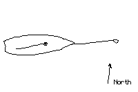
We're not going far today, just around the corner of Great LaCloche Island, and into Sturgeon Cove. We've been there many times, and it makes an excellent anchorage in the vicinity of Little Current. Entering it is rather tricky, as there are several rock shoals in the passage that must be avoided.
1700 Anchor in Sturgeon Cove. Dx=7.7nm per knot log.

Two deer, young yearlings, walk along the shore about
100 yds west of us.

1725 WX on Ch .05.  Looks like S tonight becoming W tomorrow, fair.

NOTICE TO MARINERS

C-1930 Lake Huron, Kincardine. Fog horn switched to user activated.
Click your radio microphone five times on Channel 06 to activate horn.

Lake Huron water level is 0.83 meters above chart datum

The boat has the usual problems: the throttle handle is loose and about to
fracture its mounting screw; the cockpit lockers are dirty; the dingy
floorboards are the wrong ones and don't fit into the inflatible.

2040 Forecast from Environment Canada issued at 4 p.m. July 6th

MAFOR CODED Broadcast

E. Lake Superior  12619  13619  12620  11626
Small craft warning in effect. Scattered thunderstorms

Lake Huron   13900 12410 13616  19629 Waves 1 metre; Warm frontal wave

Plain language:

E. Lake Superior
    Small craft warning in effect due to winds and thunderstorms.
    Winds East 15 becoming West 15-20,
    then increasing to W 20-25 Sunday morning.
    Scattered showers midday Sunday, then fair.

Lake Huron / Georgian Bay
    Winds variable 10 becoming Southerly 10-15,
    then veering to West 15-20 Sunday morning.
    Isolated showers in Georgian Bay, otherwise fair.
    Showers Sunday.

Synopsis: A frontal wave just west of Lake Superior moving to lie E. Lake Erie.
Weather information is probably the most important thing the radio brings us. We like to keep watch on what the forecasts have to say; they're generally pretty accurate. It is also fun to decode your own MAFOR forecast and compare it with the plain-language version from the weatherman.
Marine Forecast from Environment Canada issued at 4 a.m.

Eastern Lake Superior:  Small Craft Warning due to wind, ended.
       Small craft advisory due to thunderstorms in effect.
       Winds NE 15 veering to W 15 this afternoon,
       then becoming variable 10 knots or less tonight.
       Showers ending. Mist lifting.

Lake Huron and Georgian Bay: Small craft advisory due to thunderstorms in effect.
   Winds variable 10 knots or less becoming S 15 this morning, and veering to west
   midday and NW this evening. Thunderstorms developing this afternoon.

Mean water level is 0.83 meters above datum
Converting to inches:

    39 inches
  _____________    X   0.83  =   32.67 inches
    1 meter


Outboard Motor Oil mixture problem.

      Quantity added = 5.0 litres = 5000 ml
             Mixture = 50:1
          Oil to add = 5000/50    =  100 ml

1045 Raining lightly on and off all morning since 0800. Listening for
10 a.m. weather forecast update.

Overnight Sturgeon Cove held three yachts: ours, a 35-ft motor yacht,
and a 27-ft motor yacht. The smaller motor yacht left this morning
about 0900. I envy their ability to navigate in the rain from a
protected helm position.

Cotton clothing absorbs moisture in damp weather. A woolen flannel
shirt would be ideal on a day like this.

Reading novels. Two pots of coffee made this morning.

1100 Clearing a little. I clean up the cockpit, then get the motor out
of the locker. The dingy is wet and I have to bail it.
Twenty minutes of fishing is unproductive, but I did see one big
bass near the boat. That started the fishing juices flowing.

Marine Forecast issued at 10 a.m.

Lake Huron  Small craft advisory due to thunderstorms.
      Winds S 10-15 veering to west this afternoon then
      SW 15 Monday morning.  Scattered showers and Thunderstorms
      ending this evening, then fair.

MAFOR 12406 19419 11606 19619 14610 11510

My own decoding:

12406    6-hrs      S    0-10   Rain
19419    Occasional S    11-16  Thunderstorms
11606    3-hrs      W    0-10   Rain
19619    Occasional W    11-16  Thunderstorms
14610    12 hrs     W    11-16  Fair
11510    3 hrs      SW   11-16  Fair

1225  Lunch. We discuss our options. The sun tries to peek
through the overcast.

Things we forgot: Portable Depth Sounder for dingy; Bluette gloves,
Clothespins.
This little omission of the Portable Depth Sounder has changed all our plans! I just bought the thing last year, and it is a very handy gadget. It's a battery operated depth sounder and fish finder. You can take it out in the inflatible and explore new anchorages. That was our plan for this week, to head east and snoop around Sturgeon Bay, a larger inlet into LaCloche Island a few miles east of here. Now, since we've forgotten to bring the thing, we change plans and decide to head west. We need a new anchorage to explore, and nearby Louisa Island seems like a good choice. Since the wind is forecast to be westerly for the day, the anchorage in the lee of the island's eastern shore should be a good spot to stay overnight.
But first, we'll have to get out of Sturgeon Cove. Just as it is hard to enter, it suddenly becomes hard to leave!
1350 Underway motoring
TC 293
v 9w
MC 302
d 6w
CC 308 but since we are motoring, add 5
C 313
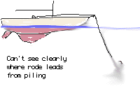
Getting free of Sturgeon Cove was a giant problem. During the night and morning
the wind shifted from north to east to south. As we swung around, we wrapped
our anchor rode around a sturdy piling, about eight feet underwater.
First, we pulled ourselves up to it as tightly as we could,
winching the anchor line on the primary genoa winch.
Looking into the water, it was impossible to tell which direction we were wrapped.
We came up on it from the west.
Using the engine in reverse we walked around to the north, then
gave it a huge tug. A big bang was heard, but we were still fast.

We seemed to have swung around counter-clockwise in the night,
so to unwrap, we continued in reverse, letting the prop torque
slowly walk us around.
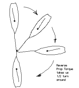
Then we winched up tight, but were still fast to the submerged piling.

The half-turn not having freed us, I decided to put it back on (or perhaps off).
We could not use reverse to walk around this time.
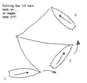
We backed a little distance off and then went forward, turing to the right, then
left around the arc.

We must have hit the right combination, because suddenly the anchor line
slacked and we were off the piling.

Our anchor seemed to be north of the piling, so I quickly pulled
in rode as fast as I could, directing Chris (at the wheel) to steer
for the anchor's presumed location.

In a momemt we had it aboard. The deck was covered in mud and tangled
anchor rode.

Our adrenaline was pumped, our hands were raw, our backs tired, and our
deck full of mud.

We washed down the anchor and untangled the rode. Once the anchor locker
was closed, we used buckets of water to wash the residue of Sturgeon Cove's
bottom off the topsides.

1500 Entering Louisa Island east anchorage. It is a simple
approach. The water is clear. We can see logs on the bottom and
avoid them in the anchorage.

Distance motored = 5.2 nm

1640 Sun comes and goes. The wind has come up from the SW,
as forecast, and we are perfectly sheltered.

We have rigged the boom tent to keep the rain off us,
should it come.

1815 Listening for 4 p.m. weather update as we roll to seas coming
around the point of Louisa Island and hitting us abeam while
we lie head to the SW fresh breeze.
As it often does in the North Channel, the wind has been building from the SW all afternoon, with the result that there is a good sea rolling down the North Channel from the west. We are completely sheltered from the direct impact of these big waves, but unfortunately they seem to be bending around the SE tip of the island and creating a tiny ripple in the anchorage. It wouldn't be bad, except that we are sitting head-to-wind, and that puts us at right-angles to the wavelets. They are just strong enough to rock the boat back and forth as we get ready for dinner.
CG Radio drones on with position coordinates of new buoyage.

Wiarton Coast Guard Radio, transmit facilities located
at Tobermory, Point au Baril, and Kilarney on Channel "Two One Bravo" (21B),
and at Meaford on Channel "Eight Three Bravo" (83B).

NOTICE TO MARINERS
      Cockburn Island: a large submerged object 1.6 km east of
      Cockburn Island in position 45 50.5 N, 083 19.0 W

Weather Advisory

At 2147 UCT Sunday July 7
Severe Thunderstorm warning issued for Southern Lake Huron.
One ashore at Grand Bend
One expected at Point Clark and Lake St. Clair
History of winds of 100 km/hour

4 p.m. Marine Forecast

Lake Superior
   Winds W15 becoming variable 10-15 tonight and
   E-NE 15 on Monday. Scattered showers.

Lake Huron/Georgian Bay
   Small craft advisory in effect due to Thuderstorms
   Wind SW 10-15 veering to West tonight,
   then SW 15 Monday morning.
   Scattered showers becoming fair. Showers redeveloping
   Monday afternoon.
MAFOR 11506 19516 14610 12510 11516

Shore Forecast for Manitoulin Island and the North Shore
   Cloudy with clear periods tonight, fog patches. Low 12
   Mainly cloudy Monday, scattered showers, High 21
   Mainly cloudy, morning showers Tuesday, Low 12 High 20

   21 = 72°F  20 = 70°F  12 = 54°F
0630 Weather Forecasts

Sudbury: Cloudy with sunny periods. Afternoon showers

Manitoulin: Foggy, otherwise cloudy with showers and thunderstorms
    developing this afternoon. 80-percent probability of precipitation.

Marine: Lake Huron and Georgian Bay
   Small craft advisory due to thunderstorms. Winds W 15-20 becoming
   NW-15 tonight. Showers and thunderstorms this afternoon

Pre-compute all today's courses

Louisa Rock Buoy to Belcher Rock    Dx = 3.25 nm
   TC   282
    v     9w
   MC   291
    d     6w
   CC   297   but motor at 302

Belcher Rock to Buoy U9     Dx = 1.85 nm
   TC   287
    v     9w
   MC   296
    d     6w
   CC   302  but motor at 307

Pass South of Bald Rock, 100 yds, when 100 yds west turn North

Bald Rock to McBean Harbour
   TC   016
    v     9w
   MC   025
    d     4w
   CC   029


0840 Reset Knot Log to zero from 3.7 nm abeam Belcher Rock buoy 100 yds to the north

0850 It is a beautiful, sunny morning, and we are away early to take
advantage of the lower winds and waves.

Our anchor came up easily, with just some fine mud stuck to a blade.
Louisa Island has excellent holding, but avoid the few logs down there.

Belcher Rock buoy was right were it should be. The McTavish Island buoy is
also in sight, about 1.8 miles ahead.

Belcher Rock was just below water, but visible from the color change
of the water from blue to light brown.

0902 Reset knot log to zero from 2.1 (5.8 nm total so far)
Abeam U8 south of McTavish Island.

    D =  2.3 to East Rock Bn, then 1.3 to Bald Rock

0930  Reset Knot Log to zero from 2.5 (8.3 total) just west of East Rock Bn.

0944  Reset Knot Log to zero from 1.2 (9.5 total). Turning N from west of Bald Rock.
We motor into McBean harbour, and turn northwest into the excellent anchorage behind aptly-named Anchor Island. The shoreline has some reeds, and it looks like the fishing would be excellent. This portion of the north shore is an indian reservation. There are some houses on the northern side of the anchorage, so we have anchored on the south side, behind Anchor Island.
I take the dingy out for a spin, doing a little fishing and some sight-seeing. Unfortunately, the shoreline has several piles of rubble and liter. Atop one prominent rock is an old mattress, surrounded by other rubbish. It's not a very picturesque view. After lunch we decide we've seen enough of Anchor Island. We'll leave, and cross the McBean channel, heading to Gibson Cove on the northeast side of Fox Island.
1150 Departing. Rain staring.

Departing McBean Harbour
   TC   196
    v     9w
   MC   205
    d     1w
   CC   206

Enter Gibson Cove
   TC   235
    v     9w
   MC   244
    d     3w
   CC   247

1320 We are anchored and tied to shore in Gibson Cove. A brief rain
shower didn't bother us because we had just put up the boom tent,
at Chris's insistence.

Gibson Cove has deep green-blue water. We know there are fish here, too.
This is our second visit, and again we are alone.

Weather Forecasts

8 July 10 a.m. Forecast

Lake Huron/ Georgian bay

   Small craft advisory due to Thunderstorms. Winds variable 10 becoming
   SE-15 this afternoon, then backing to NW 15 tonight. Mist and fog patches.
   Scattered showers.

1730 I've been fishing. I caught six perch, all kinda small and two very small.
It's a lot of work to clean all those fish, and I get bitten by six mosquitoes
in the process. Nature feeds me; I feed nature.

The fish heads are left on the rock for a seagull's dinner.

2200 Marine Forecast at 10 p.m.

Lake Huron and Georgian Bay
   Small craft advisory due to thunderstorms ended.
   Winds W-NW 15-20. Scattered showers. Chance of Thunderstorms until midnight
   Fair.
When I transcribed these notes, I though to myself, "What am I doing up at 6 o'clock in the morning?" My wife Chris is wondering this, too.
"Can't we sleep in a little," she asks. "This is supposed to be a vacation!"
0600 Weather Forecast

Lake Huron and Georgian Bay
   Winds NW 17-21. Fair next 24 hours
Now that is the kind of forecast you like, especially when you've got some sailing to the southwest ahead of you. We should have a nice reach down to Gore Bay in sunny skies. We continue our morning ritual of listening to the weather and Notices to Mariners on the radio while having breakfast and coffee. It's a staple of our cruising lifestyle.
Ship's Weather Observations
                                 Degrees-C          Millibars
Location   Visibility    Wind    Air Temp (Water)   Barometer
_____________________________________________________________
ThunderBay    15 nm      W 3      11               1012
Buoy 45001              NNW10      6 (3) (Mid Superior)
Buoy 45004              NNW 8      4 (3) (East Superior)
Soo           15 nm       W       11
Gore Bay       9 nm     NNW 5     11               1005
Buoy 45137              NNW 12    14 (14) (Georgian Bay)
Buoy 45003              NNW 10     4 (8)
In case you didn't catch it, those automated weather buoys in Lake Superior are reporting the water temperature at three degrees Celsius! That is about 36-degrees Farenheit, or only four degrees above freezing. You would not last long in water at that temperature, which is one of the things that scares the hell out of us about sailing in Lake Superior!
Entering waypoint for approach to Gore Bay as
LAT   45  57.60 N
LON  082  27.00 W
( Read what happened one trip when I didn't have the coordinates already entered in the LORAN. Not a fun day)
0945 Depart Gibson Cove

   TC   262
    v     9w
   MC   271
    d     4w
   CC   275   but motor 280


We exit Gibson Cove in a hap-hazard manner, not retracing our entrance
course. This is poor seamanship, as a rock awash off Jones Point is not
visible.

When I check the chart, finally, I see the hazard potential, and we then
turn east to give the unseen rock a wide berth.

The McBean Channel is well marked with daymarks on rocks, and it even has
a floating buoy at Bower's Rock west shoal.

We turn southward to the channel between Fox and Frenchette Islands.
Phantom Rock is just above water, with six big birds marking it well.

Using the eastern tip of Hooks Island in line with Osler Island, we
can proceed safely past. We raise sail--full main and jib--
and turn off the motor

1030  Motor off, sails up. Speed varies from 3.8...4.2.....4.5 knots.

"4.2" yells Jim, looking at the knotmeter

"Beautiful", says Chris, then "4.5" with enthusiasm!

1050 Just east of the southern tip of Hook's Island. More wind out here.

1120 East of Gavazzi Island (near Innes). Wind increasing. We take first
reef in the main. Soon after we reduce jib to about 120%.
Boat hitting 7.0 knots regularly, while LORAN shows 2-minute-average
of about 5.8 knots.

An error in entering our target waypoint makes the LORAN bearing way off.
I can see Gore Bay and it is not where the LORAN says it is.

Corrected LORAN. Now we agree on the bearing to Gore Bay.

1200 The wind decreases, and I feel we are underpowered. But we do get a
gust now and then which makes the reefs stay in.

Behind us are two larger sailboats. They were gaining on us, but once
they hit the open channel, they reef down and fall behind. We pull
away from them.

1230  Two problems!

The leak near the NAV station is back. It seems to trickle around the motor
box. Perhaps too much weather helm on starboard tack.

The Gas tank for the outboard leaks some gas into the cockpit. The fumes
can be smelled in the cabin. We open all the hatches, the motor box, and
the cockpit lockers to air out. I wash the cockpit down with soap.

1300 Below, looking for the leak, the wind comes up and rocks the boat
around, making me seasick.

1310 Fairly confident we have aired out the cabin, we start the engine.

We heave-to to take the main down. The boat is very stable in this condition.
We motor to the dock at Gore Bay, tieing up at Dock 12.

With taxes, etc., it costs about $1/foot to stay. The showers are worth it.

The main dock has new red paving stone surface, giving it a very nice look.
"Better than that black asphalt that used to get on your shoes and on people's
boats," says the dock attendant.

CYC - Canadian Yacht Charters has a big fleet of boats. We take a tour of
CATNIP, a 32-ft trawler that charters for about $3,000/week. Nice boat.

CYC helps me find the right clevis pin for the broken boom vang. A perfect fit!

A lobster yacht attracts my attention. There's a sad story behind it.

It was built by the old dockmaster, who spent several years building her.
He retired, and took her on a cruise to Florida with his wife.
Then he passed away. The boat is for sale.
At least he got in that one big cruise.

In the harbour, the sun and rain come and go. We tour around. For dinner we go
to the Octogon house for advice. The receptionist gives us a tale about
Gordon's Lodge. We decide to try the new "Twin Bluffs" restaurant in
town, run by John Maskevich.

It's in the downtown, up the hill from the post office.

It's nice. There is a lot of art on the walls. A back wall has an
exhibit of the owner's personal collection of paintings by
"The Group of Seven."

"These artists painted mainly Ontario landscapes form 1890 to 1990,
the last just passing away recently," according to our waitress.

Chris and I give the exhibited work mixed reviews.
For more information on Gore Bay, visit my North Channel website. There are several pages on Gore Bay and its attractions. But be sure to come back here to read the rest of the cruising notes!
TASKS THIS MORNING

    Chris               Jim
 ________________________________________________________
1. Water Jugs       1. Look at dingy and fix up something
2. Can return       2. Buy beer
3. Ice blocks       3. Top off water tanks

ITENERARY

Drop off empties
Go to museum
Call Mom
Return to boat
Go to point
Take some pictures
Get the ICE
Go back to boat

1200 Lunch. Departing afterwards.

The last of the PINE RIVER FROMAGE EXTRA FORT (extra aged cheddar cheese)
was consumed today.

We've been sailing with:
	- one reef in main
	- jib reefed to 100-percent
	- occassional 6-foot seas on our port stern quarter
	- knot meter hitting 7.8 knots!


1515 Abeam Osler Island.

In the lee of Hook Island we did the following, in this order
	1. rolled up jib to small storm-jib size
	2. started engine
	3. went into a heave-to
	4. lowered main and secured it to boom
	5. swung around and jibed back onto course
	6. increased jib to about 80-percent

We were then motor-sailing at 5.5-6.0 knots with jib-only.
The reefed jib gives us some stability.

Between Eagle and S. Benjamin Islands the seas were confused,
and Voyager III  began a miserable roll, back and forth,
because we had little sail aloft to stabilize her.

"Is this what a trawler would be like," asks Chris, "It's terrible!"

North of Osler Island we can see Phantom Rock, or at least
we can see the surf on it. This is our safety mark, and we can
now turn west when north of the second islet (unnamed) at
Eagle's NE point.

The course is dead-to-wind now, so the jib is rolled up. The
engine pushes us at 5.0 knots at 3000 RPM.
The boat wind is 25-30 knots.

By now we are both in long pants and jackets.
We left Gore Bay in short sleeves and shorts.

It is a mile motor into this "strong breeze" before we can
enter the north harbour at Eagle Island.

As the harbour opens up, we see a huge power boat--a yacht--
then three sailboats. We'll make five boats total in the
harbour.

We pick our spot well-spaced between the other boats,
and we drop our 13-pound Danforth anchor into
eight feet of water over a sandy bottom with some weeds.

The water clarity is not that good here, and you
cannot see the bottom at 8 feet (indicated).

It takes a second attempt to hook up, but then we're
anchored, the motor is off, and the sailing is done for the day.

I return to the cabin to get out of the wind and sun,
Fortunately, Chris has energy to get the fire going in
the grill. I have a beer and do the log book.


1600   4 p.m. Forecast

Western Lake Superior
	Winds SW 15-20 diminishing to S10 Thursday morning. Fair tonight.
	Scattered showers Thursday morning.

Eastern Lake Superior
	Winds W 15-20 backing to SW 15 overnight. Fair

Georgian Bay
	Winds W 15-20 diminishing to SW 15 Thursday. Chance of a shower
	tonight, otherwise fair.
	MAFOR 15620  12510

LORAN position noted as
   LAT   46 06.50
   LON  082 17.94

2000 Fished without success until dark.
0705 At anchor in Eagle Island north harbour.
In the harbour are
   MISCHIEF III -- a C& C Custom 38 from Michigan

   WISHES GRANTED II --a 58-ft Jensen Motor yacht from
                       Bloomfield Hills, Michigan

   A Catalina 27 and a similar-sized sloop from a Ypsilanti, Michigan
                     camp, with six boys and two adults aboard.

Weather Round Up
Gore Bay   WSW 7    15°C 1021 MB
Kilarney     W 9    15°C 1021 MB
Buoy 45137   W 14   14°C 1021 MB  (Georgian Bay)
Soo        SSW 3    11°C 1020 MB

NOTICE C-1905 - Michipicoten Island
Michipicoten Island Fog signal on continuously

Weekly Mean Water Levels July 9, 1996
Superior is 0.46 meters above datum
Huron is 0.84 meters above datum

Weather Forecast issued at 4 a.m.

W. Lake Superior  Small craft advisory due to Thunderstorms.
   Winds S 10-15 backing to SE 15-20 then backing to NE
   Showers and Thundestorms, heavy at times, begining this morning

E. Lake Superior  Winds SW 10-15 backing to SE. Chance of
   of showers and isolated thunderstorms tonight.

Lake Huron and Georgian Bay  Winds W 15-20 backing to SW 15 this morning
          and backing to SE 10-15 tonight. Fair.
          Chance of showers tonight.

Synopsis: At 4 a.m. a large 1024 mB HIGH over NE Indiana.
          A 1018 mB Ridge NW through Lake Superior.
          A 1005 mB LOW over SE Sask. with a
          1008 mB trough N. Sask through E. Wyo.

By 4 a.m. Friday a 1025 mB HIGH Southern Nova Scotia with
          1016 mB broad ridge to 100 miles North of Lake Nipposing.
          1010 mB LOW NE Minnesota with 1012 mB trough to E Nebraska.


0745 Clear morning. Light dew. Blue skies. Breeze from the SW still.

Weather Forecast issued at 10 a.m.

W. Lake Superior--Small craft advisory due to thunderstorms.
                  Winds S 10-15 backing to SE 15-20.
                  Showers and scattered thunderstorms tonight.

E. Lake Superior--Small craft advisory due to thunderstorms.
                  Winds S 10-15 backing to SE this afternoon
                  and increasing to SE 15-20 tonight.
                  Chance of showers today.

North Channel and Georgian Bay--
                 Wind SW 15 backing to SE 10-15 tonight.
                 Chance of showers, otherwise fair overnight.

Pre-compute some courses for today

Eagle Island 's islet to Bower's Rock
   TC   078
    v     9w
   MC   087
    d     5e
   CC   082
One leg to get us up to the McBean Channel's west entrance. Then through the McBean Channel, following the buoyage. Then a second leg to take us down to Bedford Island, aiming for the little group of islands at the north end of the anchorage.
East Rock to Five Island
   TC   117
    v     9w
   MC   126
    d     5e
   CC   121


1230 Abeam Irwin Island, McBean channel. Under sail with 150% genoa only.
Making 4.5 knots

1248 Abeam East Rock
Speed = 4.0 knots
Distance=7.3 nm to Bedford Island
Time= ( 60 x 7.3 ) / 4   = 1 hour 50 minutes

ETA at Bedford Island = 1500

The wind dies around 1430 and we motor the final 5 nm to Bedford Island.
As we enter the harbour, the wind pipes up from the South. We anchor off
Batoche Point. Later, White Pearl , a chartered C&C 29 enters
the harbour and anchors 100 yds west of us.

I have more trouble with the dingy floorboards. Chris helps me as
we go ashore to rebuild it, again.
Around 1700 I catch a smallmouth bass. He hit the "Northport Nailer" as
I trolled along the weed bed in SW of the harbour, in Cutknife Cove.

1900 Anchored in Bedford Harbour near Batoche Point.

Final weather forecast for tomorrow: Wind SW 10-15 backing to SE then E
by Friday afternoon. Chance of showers Friday, otherwise fair.
We are enjoying our last night out at anchor on this cruise, when I notice that there is a very unusual gathering of birds in this bay. Just to the south of us, in the lee of Batoche Point, hundred of birds are gathering, circling overhead and landing on the water. We wonder what is going on. We'll get the answer tomorrow morning...
0800 Wind has shifted to NE overnight.

Our cockpit looks like an Alfred Hitchcock movie about mayflies!

Now we know what all the birds were excited about last night after dark,
when they made a huge racket for several hours.

Weather Forecast (Shore)
   Mainly cloudy with risk of Thunderstorms. High 23 (76), Low 15 (58)
   Precipitation Probability: Today 60-percent
                              Tonight 40-percent
                              Saturday 60-percent
What happened was a huge hatch of mayflies. There are now several hundred of them attached to the boat and its rigging. The birds must have had a feast on these. Now it's my turn. It takes an hour of picking them off, throwing them downwind, and washing down the decks to get the boat ready to sail again.
We want to investigate the goings-on over on the other side of the bay. We can see several large orange floats in the water, and some new docks that look like recent construction. Also, on shore is a new building or two. In front of this scene there is a big collection of fishing boats. After checking the chart to make sure there is enough water over there for us, we head that way so see what it is all about.
1045 Underway. Rainbow trout being raised at Fish hatchery on East Rous Island
It turns out that it is a "trout farm", where some Indians are raising Lake Trout. The fishing activity is a result of an accidental release of thousands of Lake Trout from their fish pens. Turtles ate through the pen's nets, releasing the fish into Bedford Island harbour. We watch as boats are reeling them in. All those extra fish in the bay must have increased the pressure on the other fish, too, making them a little hungrier and more likely to strike. Maybe that is why that smallmouth hit that big lure I was trolling.
We take the safe way out of the harbour--the way we came in--and don't take a chance on the passage to the north of East Rous Island, although it looks like there is plenty of water in there. Southward down the Wabuno we motor-sail, heading for Little Current and the conclusion of our charter. By the time we get to Spider Bay Marina, the wind has really built up from the Northeast, and we have a bugger of a time getting into our assigned boat slip. There's more to that story, but I'll have to tell it another time.
Hobbs times 3649.9 (at finish)
         -  3637.2 (at start)
         =  0012.7 hours motored

Fuel added = 13. 9 litres

Repairs During Cruise:

1. Noted missing velcro retainer on Leech Rope of genoa.
   This causes excessive flapping of leech of sail.
   Moved retainer from foot rope to leech rope.
   Foot rope not as likely to flap.

2. Adjusted cutlass bearing to suppress excessive leaking.
   Keel sump was taking 5-minutes to pump dry from
   overnight leaking.

3. Insulated bare AC wiring in bilge which was lying
   against fuel tank and creating enormous hazzard
   should AC power be used. This was the old
   circuit to the water heater, since removed.

4. Move cabin curtain retainer back to original position.
   Curtain was improperly pinned up on outboat side and
   in the way of settee cushion.

5. Replaced throttle handle retainer screw. Old one was
   improper head type. Fifth time I've replaced this
   screw on this boat.

6. Replaced boom vang clevis pin with proper size pin.
   Took an hour of rumaging at CYC in Gore Bay to find
   one that would fit properly.

7. Rerove main sheet for smoother operation.

8. Adjusted SHALLOW GAIN on depth sounder
SECOND TRIP
  Vessel........Voyager III
  Crew..........Jim, Chris
  Duration......7 days
  Dates.........August 17-24, 1996
  Destinations..Sturgeon Cove, Sturgeon Bay, Sturgeon Cove,Sturgeon Cove,
                South Benjamin Island, Croker Island, Spider Bay Marina
Hobbs time at start = 3749.3

1410 Departing

Installed new bilge pump.

WX fair, warm. Wind W 10-15

8 nm away we reach Sturgeon Cove. We anchor just east
of the first range rear marker.

A large group of campers with PWCs (Jet Skis) have taken over the beach.
They look like indians, and another boater tells us they dismissed
a sailor who complained to them about their noise by announcing,
"It's our f___ing island."

Tonight's meal: Ratouille & Bobali. Delicious!
Water Level August 13:  Huron = 0.85 m above datum  (33 inches, or 2 ft 9 inches)

Forecast 4 a.m. August 18

W. Superior   Winds S 10-15 increasing to 15-20 late afternoon.
              Mist and Fog. Waves 1-metre.

E. Superior   Winds SE 10 increasing to 15 tonight.
              Mist and Fog developing this afternoon.

Huron         Winds variable 10 or less becoming SE 10 tonight
              Fair. Waves 1 metre or less
              (MAFOR 13900 12300 13310 19300)

Synopsis: 1022 mB ridge from Georgian Bay to James Bay

Precompute courses

   TC   090          TC  180
    v     9w          v    9w
   MC   099          MC  189
    d     6e          d    1e
   CC   093          CC  188

Sailing Directions (my own)

Sail due east until abeam BnR (Red Daymark) North of Island 2613.

Continue east, then turn due south and
pass between 3-foot high rock (will be awash)
and islet on LaCloche shore.

Watch out for shoal making out SE from rock.
Should carry 14-feet if in mid-channel.

Turn east and enter cove,
leaving three rocks to your starboard (South).

1100 Coasting eastwards towards BnR N of 2613

West tip of Island 2615 is a good mark to turn southward

Reciprocal Courses for (hasty) exit

   TC   000      TC   270
    v     9w      v     9w
   MC   009      MC   279
    d     5w      d     5w
   CC   014      CC   284

We enter the eastern cove and anchor off the eastern-most point,
midway between the two shores.

The only other boaters, a Canadian couple aboard their 31-foot
Chris-Craft modern express cruiser, leave the harbour around
1600 while we are napping.

A family in a small outboard visits after dinner. They talk
with us. They own island 2613, "bought her three years ago,"
he says.

"One guy owns all of Great LaCloche. He's in the Cement
business in Sudbury. It's a wildlife preserve."

"You'll see mink, otter, deer, and other wildlife here.
It's also about the best fishing spot around."

His recommendation inspires me to more fishing that evening,
but I don't catch anything.

The cove is completely open to the west. It is oriented
just perfectly so that from our position deep inside
we can see westward across 20 or more miles of open water.

Overnight the wind shifts to the south and east, the directions
of maximum protection for our anchorage.

We are asleep by 2130.
0700 Up early, I wash the heavy dew off the cockpit
and load the dingy for fishing.

Another early riser comes to fish at the mouth of
the cove. He casts toward shore on all the
rocky outcroppings.

I troll around the bay. One possible hit is lost.
No fish are caught. A large turtle is sighted.

Chris has a cold and she has no energy. Her body aches.
She spends most of the day in the cockpit under blankets.

After lunch, fishing improves. I catch a small perch,
barely larger than the lure. Finally, my persistance
pays off. I get a beautiful smallmouth bass.

I wake Chris up to show her.

"It's huge. The biggest one you've caught," she replies.

I release the fish unharmed, more from from an aversion
to all the fuss and bother of cleaning it than from
devotion to fish conservation.

The weather stays warm and sunny all afternoon, and
at 4 p.m., just as we are about to go for a swim,
we get the afternoon weather forecast.

The shoreside forecaster is calling for winds of 30 knots
from the west!

This news prompts us to action. We rig for travel.
The anchor is up and stowed in record time, and we
exit the cove, which as I mentioned, has a 20 mile fetch
to the west. It would not be a good place to be in 30 knot
westerlies.

We make a quick motor back to Sturgeon Cove. The western
end is unoccupied and that suits us fine.

1730 Now we really need a swim to cool off. The water
temperature is around 72-degree F and swimming in it
is a delight.

1800 Two slightly over-hungry adults bicker about using
the grill to cook dinner. Too much mess, I contend.
An appetizer of nachos and sticky-buns, washed down
with beer and tea (respectively) takes hunger out
of the shipboard harmony equation.

After dinner (sausage, onions, and peppers simmered
in the frying pan and served over rice), I rig
the dingy for fishing.

Regarding the dingy, on the 2-3 mile motor today
we did not remove the outboard from the dingy.
Here are my observations:

   1. Dingy tows fine with outboard in place.

   2. Outboard must be rigged in the tilted-up
      position. If outboard is in the water,
      the drag is excessive.

   3. Outboard will tilt down by itself in
      in ten minutes of motoring.

   4. Need to increase tension on tilt-lock screw.

Around 1900, radio Ch16 comes alive with an unusual call:

"PAN--PAN--PAN"
"Any vessel in the vicinity of Little Current"
"This is EASY LIFE."

Wiarton Coast Guard responds:
"EASY LIFE, this is WIARTON. What is your situation?"

"We've hit a rock and are being blown onto Bear's Back Island,
the Southeast side," says EASY LIFE's captain.

"We are trying to get our anchor to catch.
"As we come into shallower water I hope we will
be able to anchor."

Wiarton asks for a description of the vessel, number of
people aboard, and it they are taking on water.

"No, we're not leaking. It looks like we are
going to smuckle-up to shore."

Wiarton broadcasts a request for assistance and
recruits SURVEYOR IV, about ten minutes away.
The two vessels hook up via radio and plan
their actions.

Eventually, SURVEYOR IV succeeds in towing
EASY LIFE off the rocks of Bear's Back Island
and into Little Current.

It's a real-life drama that entertains us for an hour.
0830 Sleeping in after a restless evening that brought showers all night.

The forecasted winds of West at 30-knots are not arrived.
Instead it is fog and mist with light winds. Maybe they
meant 30 kilometers-per-hour???

1010  Marine forecast issued at 10 a.m. Toronto

Lake Superior Small craft warning due to winds ended.
              Winds W 15-20 veering to NW 15 tonight.
              Scattered showers ending. Becoming fair.
Lake Huron & GB  Small craft warning due to thunderstorms
              Winds S SW 15-20 veering to W this afternoon
              then SW 15 overnight. Fog and mist.
              Scattered showers. Fair Wednesday
Synopsis: At 10 a.m., a trough with central pressure 1012 mB lies NE-SW
          through Sault St. Marie. 1022 mB High over S. Minnesota
          By 10 a.m. Wednesday, a trough 1014 mB lying NE-SW from
          Montreal to Buffalo. High 1024 mB over central Lake Superior
          with NE/SW ridge.

1030 Raining lightly. "This is good weather to go fishing," says Chris.

1100 A loon is fishing near the boat

1300 Two loons fishing

1325 Radio reports a bear (!) swimming toward Croker Island.
"At first I though it was deadhead, then its ears moved,"
says the Captain on the radio.

1600 Weather forecast issued by Enviroment Canada from the
Regional Center in Toronto.

Lake Huron/Georgian Bay  Small craft warning due to thunderstorms ended
MAFOR  12626  12713  12703  12903

Plain Language: Winds W 15-20 veering to NW tonight
                then decreasing to NW 10 overnight
                Variable 10 or less on Wednesday

Synopsis: At 4 p.m. today a 1012 mB low NE/SW over James Bay .
          A 1022 mB N/S ridge over Minnesota
          At 4 p.m. Wednesday Trough 1014 mB NE/SW over Quebec
          Ridge 1024 mB NE/SW over Buffalo.

DIFFERENTIAL GPS OPERATIONAL
NAD 83

Cardinal Antenna Site at:
   44-deg 47.28488' N
  075-deg 25.27676' W

After dinner we get the boat ready for tomorrow, when
we plan to move westward.

The major task is to get the outboard off the dingy and
stow it in the cockput locker. We also remove the boom tent,
stow all the cushions and fishing gear (and other loose items),
and check the anchor.

We are experiencing a strange wind. Aloft, the masthead fly
shows westerly winds, but at the surface the wind is
a back eddy blowing from the east. As a result,
our position varies a lot, and we are
often lying broadside to the small waves that
turn around the point and trickle into the anchorage.
The beach in Sturgeon Cove is a rare occurance of sand among the rocky shores of the North Channel. Eons of northwesterly winds have deposited a hundred feet of beach on the southeastern corner of the cove. It is a very nice spot for a shore landing, and its a great place to swim in shallow--and therefore warmer--water. We take a spin in the dingy and go ashore at the beach.
The previous occupants, the large group that arrived in several 17-to-20-foot outboats and spent the weekend here cooking, camping, and jet-skiing, have left their trash. A rough count finds about 140 bottles, mostly beer. In Michigan, they'd be worth about $14 in bottle deposits, but in Ontario, where it's five-cents-per-bottle, they are worth only $7, and that's Canadian money. We think about hauling them all back to our boat in the dingy--it would take a couple of trips--and then carting them down to Little Current to return. We'd have to load them into the car and drive back to the bottle return.
We'd like to clean the mess up, but it is really impractical for us to do it with our sailboat. It would take us all day to sail down to town, return the bottles, and get back up here into the cruising grounds. We would have a cockpit and cabin full of bottles, and the cardboard containers are getting rather soggie. Ultimately, we decide to leave them there, a sad reminder of that group's weekend ashore.
While we are at the beach, another boat (26' MacGregor)
moves and anchors close to ours. A second boat enters
the anchorage and joins the fleet.
When we return from our trip to the beach, we find ourselves
with two close-by neighbors, perhaps a little
too close-by.

After dinner I decide that these other boats are too close
to us, and we will have to move.

Just as we haul anchor and move to a new spot, another new boat
enters the cove. He makes toward us to anchor!

"Please don't anchor too close to us," I yell,
"we just moved to avoid some other boats."

I move even farther from shore, and when we settle
back on the anchor we find ourselves riding
to quite a little chop. This gives the boat
a quick rolling motion. It won't be the most
comfortable night, but at least we won't swing
into another boat in the dark.
That evening, the sky is wonderfully clear thanks to the strong breeze. The forecasted winds, West at 30 knots, have finally arived. From the cockpit I observe some unusual astronomical phenomenon.
In the morning we get underway and broad reach westward
on a light easterly breeze.

The wind backs to north and dies around 1100, forcing
us to motor.

Around 1145 we hit a SW breeze as we clear Clapperton
Island's lee, but we don't bother to re-hoist the sails
to take advantage of it.

A large sailboat shows a "Diver Down" flag, east of
Robertson Rock Buoy

1230  At anchor in nice cove on the north shore of
South Benjamin Island.

Weather forecasts

Western Lake Superior. Small craft warning due Thunderstorms.
                       Winds S 10-15 veering to SW 15-20 tonight
                       NW 15 Thursday morning. Scattered showers
                       Thunderstorms developing tonight. Waves 1 metre
Eastern Lake Superior Winds variable 10 knots or less, becoming SE 15 tonight
                      and SW 15 overnight. Fair. Mist patches. Scattered showers
                      after midnight
Lake Huron Georgian Bay  WInds variable 10 becoming S 15 tonight and SW 15-20
                         on Thursday. Mist patches. Scattered showers
                         and chance of Thunderstorms Thursday afternoon.

"The weather is finally 'summer'", says Chris.
We relax under hot clear skies, and we watch the rest of the
boats come and go from our anchorage in the cove.

"You've got the best spot," says a neighboring boater as he
rows by in his dingy.
Weather Forecast

Lake Huron and Georgian Bay  Smallcraft warning due to winds.
                             Small craft warning due to thunderstorms.
                             Winds S-SW 20, veering to NW 12-20 tonight
Synopsis: Trough and Wind Shift Line, central pressure 1012 mB
          over Northern James Bay to Western Lake Superior,
          moving to lie from Ottawa to Sarnia by Friday.

We are lying with very short scope and with only two feet of water
under our keel. The forecast is for thunderstorms.
We decide to move, and Croker Island looks like the
best combination for protection from the current wind (SW)
and the anticipated wind (NW).

Again, the trip is so short that I talk myself into leaving
the outboard on the dingy. I do, however, tighten the
tilt-friction adjustment so it is very stiff.

We set out for Croker. Once out of the lee of S. Benjamin Island,
the waves are running rather tall, and I watch the dingy flail
around in our wake, wondering all the time when the motor is
going to tilt down by itself and cause a mess.

We get our favorite anchor spot in Croker, although
a fellow boater who followed us in tried to steal the
shoreline tree that we're tied to.

The lobster yacht KEREMEOS is swinging in the center of the
harbour. I stop by for a chat.

Aboard are George and Betty from Goderich, He's a farmer
(900 acres) who "made it raising cattle." He's  had a
lot of boats (13-15) but is enjoying this one.

"I get more complements on her looks," he says.
"People stop in to tell me how much they like her."

KEREMEOS does have a northeast heritage. He got the boat
from New Brunswick, where a boat building school put her
together. She'd been for sale for two years, starting
at $45,000. He bought her for $22,000 on the hard, based on
some photos and a good survey.

KEREMEOS is 28-feet and has a sedan cabin top, with
an inflatible on the coachroof and a hard dingy on
the swim platform. She has a 302 ci outdrive Mercruiser.
In the main salon the helm station is starboard with
a dinette behind it. On port, the galley is forward
and a single berth/settee behing.  Below is a head,
a hanging locker, and two single berths, set over/under
instead of the usual vee-berth style.

Chris and I row back for a visit after dinner.
ARV Little Current Spider Bay marina approximately 4 p.m.

Dingy swamped with water.
After many years of towing the dingy in all sorts of weather, we are finally hit with some bad luck. Running eastward before a nice westerly in the open waters north of Manitoulin, we have been averaging over five knots, gybing downwind to avoid being on a dead run. The following seas are averaging about four feet, occasionally higher. About two miles west of the Little Current passage, the boat speed suddenly seems to have fallen, and I notice that some other sailboats a few miles behind us seem to be gaining on us. (I've been watching them all afternoon in a unilateral and spontaneous "race" to Little Current.)
The change in boat speed is caused by the dingy. It now has a big load of water in it! The tension on the tow line is unbelieveable. This must be how all those towing eyes get pulled out of inflatibles: people towing them after they have filled with water.
To avoid ripping the towing eyes right out of the inflatible fabric, we slow down by dropping sail, turning on the motor and idling along at 3 knots. This eases the strain on the dingy's painter, but it is still considerable. The waves are too big to mess with the dingy out here, and we decide we'll just limp into Spider Bay marina with the partially filled inflatible in tow.
When we do get to the gas dock at Spider Bay, I hop in the dingy with a hand pump, and start pumping. It takes me twenty minutes to get all the water out. The water is roughly 4-ft by 8-ft by 6-inches, or about 16 cubic feet. Fresh water weights about 62 lbs/cubic-foot, so that means there were
16 cubic-feet X 62 lbs/cubic-feet = 992 lbs
of water being towed! That is a lot of weight. No wonder the tension on the dingy painter was so high. We were towing half a ton of water along behind us. Now I know what causes the towing eyes to be torn out of inflatible dingies: they get swamped with water and the huge strain of all that weight being pulled tears the fabric.
We have an afternoon of work ahead of us. The boat must be cleaned up and readied for the crew arriving to take it south. All our gear has to be loaded back into the car, although that is easier than the unloading because of all the food that's missing. We have to rendezvous with the incoming crew; they've got a car that we'll drive back, while they bring the boat down. There is plenty of activity to fill the remainder of the afternoon. By early evening, with fresh showers and clean clothes, we are off for a last-night dinner in town, returning to The English Pantry , a newer restaurant right in the middle of the main street that seems to be able to serve up an excellent dinner.
After dinner, we take a last stroll down the town docks, observing the boats and people that remain. We top off dinner with ice cream from Farquhaur's, another ten-year-old tradition. We start to notice that they sun sets a little early for summertime; it too knows that these days are numbered. And it's just a bit cool for the shorts and short-sleeves we are wearing, although the local kids are still diving off the dock into the cool water. The last log entry records the motor useage. It is a nice low number, just a little over an hour a day. Then, suddenly, our cruising for 1996 is over, and we are driving in the car for the ferry to Tobermory.
Hobbs Time 3757.1 - 3749.3 = 7.8 hours motored
Copyright © 1997 by James W. Hebert. All rights reserved.
Page Last modified: March 24, 1997;
URL:http://continuousWave.com/sail-logs/nc1996/index.html
JWH