The material presented here consists of two parts,
contemporaneous notes, indicated by the typewriter font,
and material written after the cruise, in the standard font.
1997 CRUISE
  Vessel........Serenity
  Crew..........Jim, Chris
  Duration......7 days
  Dates.........August 9-16, 1997
  Destinations..Browning Cove, Marianne Bay,
                Little Current, Sturgeon Cove,
                La Cloche Island, Little Current
We are down to just one week this year, and we've had to settle for our non-favorite boat, Serenity. We have come up via Sarnia, taking the Chi-Cheemaun ferry over on Friday afternoon, and staying at our favorite Hawberry Motel in Little Current. Friday night we grab a cold six-pack at the Brewer's Retail, split a carry-out Fish 'n Chips dinner from the little chip-wagon place, and dine in the park overlooking the harbor. Then we go down to the dock, Farquahar's Ice Cream in hand, for a stroll along the wharf and some boat sight-seeing.
Friday night in Little Current.
We meet a most interesting fellow,
Jim Perry, a music teacher from Kirkland Lake, Ontario.
"Where the streets are paved with gold," he tells us,
explaining an old story of how a road grader accidently
used a pile of high grade ore instead of an adjacent
mound of rocks to make the roadbed.

He and his wife have been cruising for a month on
IOLANTHE, a highly modified SeaRay from the 70's.
Jim has added his own galley, a diesel heater,
propane stove, and rebuilt the dashboard, adding
an autopilot. And refrigeration. He invites us
aboard to show us the thermometer from the
icebox: -2 degree Celsius.

A little generator running on the swim platform
charges the 12 V battery that runs the cold pack in
the fridge. This relieves the main engines from
battery charging duty at anchorage.

"I've got a thousand hours on her (the Chevy
305 V8 Merc Cruiser engine) and they tell me
it's now worth about seventeen cents a pound
(i.e., scrap metal)."

In a roundabout story, he confesses his desire to
convert to diesel, specifically a new Yanmar
4-cylinder, in order to make a lengthy cruise
down the Mississippi River.

He's hauling out tomorrow, towing IOLANTHE by
trailer the 400 miles back north to Kirkland Lake.
"This (the North Channel) feels like the
southern carribean to us," he jokes.
Back at the Hawberry, we have a nitecap and turn in. It has been a long day.
Saturday morning I walk to the donut shop for a couple of large coffees and some jelly-filled donuts to get us going. All this crazy food; we never eat this stuff unless we are on a vacation!
The previous users of the boat have departed early, giving us a few extra hours to get aboard. By eleven o'clock we are just getting ready to leave, but there are a couple of items remaining to buy. One thing we still need is a fishing license. When I check the Canadian cash, I find we are rather short!
1130  Aboard Serenity, lying Spider Bay Marina. Where did all
the cash go?

CANADIAN CASH EXPENDITURES

   Outboard Fuel............. $6.50
   Ice........................ 8.00
   Beer-Case of Blue......... 33.00
   Coffee and Donuts.......... 6.00
   Beer-6-Pk Blue............. 8.00
   Friday's Fish & Chips...... 8.00
   Friday's Ice Cream......... 6.00
   Groceries................. 23.00
   Farm Market Produce....... 18.00
   Pine River Cheese.......... 8.00
   Friday's lunch............. 5.00
   Chicheemaun snack.......... 8.50
   ________________________________
   TOTAL                    $138.00
We are down to about $35-Canadian, but we won't have much to spend it on, once we leave the dock. The weather is beautiful. It's a bright and sunny day, and the winds are from the west, so our sail east will be an easy one
1300 Waiting for the 1 p.m. bridge opening,
     then on to Browning Cove.
Once past the bridge, we raise sail properly, first coming into the wind and getting the main up, and then letting the genoa unfurl. We begin a leisurely sail in preference to motoring. When Browning Cove on Heywood Island opens up for us, we take a shot at sailing right in. We used to try this stuff all the time when we were first up here, then we hit a few rocks and got overly cautious. Now we feel like seasoned veterans who can sail into an anchorage we're famliar with. The jib is put away, and we tack up the entrance with just the main. Our progress is steady, although we do make a hasty retreat when we come about right on top of the 7-foot patch just northeast of the center of the channel. Chris finds the sounding on the chart, right where we were. Forgot about that one.
1515 Anchor holding fast, SW side, Browning Cove,
     Heywood Island.  Dx = 8.1 nm sailed/motored.

     Depth indicated = 15 feet
     Rode = 75 feet
     Scope = 4:1

     Wind SE/S at 10-15
     Temp = 80's to 90
     83 degrees in the cabin. Hot and Sunny

We are both sun burned.
We sailed into the harbor under main only, tacking up
the entrance at 2.0 knots. We used the engine to
manuever for anchoring.

Sail repairs: Re-rove slab reefing lines. Secured leech line to boom.

Boom tent needs some new lines rigged on it.

2015  Returned from a tour of the anchorage. About a dozen sailboats
are swinging at anchor. The FORCE 5 Hp outboard started on the first
pull and ran steadily. We motored all the way eastward in the harbor
and then back west, down to the end of the small cove.
Zipping around in the dingy is a blast. With the outboard on it, you can extend your range and cover a lot of water, especially against the wind. Without the motor, we'd think twice about rowing off downwind. With two people in the inflatible, it doesn't row worth a hoot back to windward. We also have the battery-operated depth-sounder, so we can take soundings as we putt-putt along. These two--the motor and the depth-sounder--have been great investments.
Now standing by for the weather forecast. Clouds forming.
Evening is cooling off.

From Radio Channel 21B

   Lake Huron is 1.2 meters above chart datum.

Marine Forecast, issued at 1600 Saturday August 9 at Thunder Bay

   W Lake Superior   Small Craft Warning (SCW); S20 becoming W, mist patches
   E Lake Superior   S 15-20 becoming W15 Sunday afternoon, mist patches
   Lake Huron        S 10 increasing to 15 Sunday morning, fair. Chance of
                     Thunderstorms overnight.

   Synopsis: NE-SW ridge;  N-S cold front, 1008 mB Sault Ste. Marie.

Diner Notes:  Corn and Pasta Toss

Pasta Toss:  lovely tomatoes
             garlic
             broccoli
             cheese - don't toss the cheese--it makes a gooey mess

Vino: Red Box wine at room temperature; delicious

Corn: throw the pasta into the corn's boiling water
      to conserve time and stove fuel

Pasta Toss was plenty. The corn was extra and perhaps extravagant
0800   Blue sky awaits the late-rising Christine.
The breeze from the south is warm.

0840  Weather changing. Chris is up, but the blue skies
are gone and cold air is in the breeze.

0900 Forecast

Lake Huron North and Georgian Bay
   Small Craft Warning due to Thunderstorms ended
   Winds S 15 veering to W this afternoon and to
   NW late this evening. Showers. Chance of
   Thunderstorms this afternoon.

MAFOR CODED Broadcast
14413  12613  19616  12713

1045  Sailing. Off E27    S = 4.2 kn

TC   044               TC   035
 v     9w               v     9w
MC   054               MC   044
 d     4e               d     5e
CC   050               CC   039

The nature of the day is changed by the sudden rain
that greets our exit from Browning Cove.  Visibility
is poor. Neither of us is in foul weather gear. Chris
closes herself in the cabin to change; I feel the
warm rain soaking through my Patagonia jacket.

Once she is properly dressed, Chris relieves me
at the helm. I go below and change into foul
weather gear.

By the time I am back on deck we are half a mile
off Heywood Island and unable to see Frazer Bay.

I have to go back below and start a DR plot.
Ahead of us is nothing but mist and fog.

We get the genoa unfurled and shut off the diesel.
Speed is about 4 knots, with a following wind
and sea.

The rain increases to a downpour. We have just
passed E28 at East Mary Island, so at least we
know where we are. The speed is too fast for our
visibility--well, not really--but it feels
safer to slow down. So I roll up some jib and
we drop to 2.5 knots.

Our slow transit across the bay finally permits
us to see McGregor Point ahead, so now we're
back to visual navigation.

1200 Entrance to Baie Fine in sight. We furl the
jib and switch to power. Behind us a large yacht
approaches, the one-hundred-fifteen-feet of "Chanticleer."

Our relative speeds look to me like they'll
overtake us just at the entrance narrows at EH2
off Frazer Point. I reduce the engine to idle
and wave her to overtake us now, in the open bay.

"Chanticleer" charges past us with waves from
all aboard. Besides, we can follow her track through
the entrance.

EH2 is a red marker, and should be left to starboard
by vessels entering Baie Fine, but it never looks
that way on the chart. The way it's drawn it tends
to lead you to take the buoy on the wrong side.
We've been there, too...


1730  Rain. Rain. Rain. A very wet afternoon
We had a respite to dry everything off and rig
the boom tent, but now is has started raining
again and with some conviction behind it.

So far, the boom tent is repelling water fairly well.
We have the hatch open and we're not getting wet
below.

Let's get the 4 p.m. weather forecast...

...from Ottawa, issued at 1730 EDST:

Winds NW 10-15 diminishing to 10 or less overnight;
Scattered showers ending this evening, then fair.
The rain finally abates after dinner, and I stick my head out from under the boom tent to get some air. The sun is starting to set, and there are beautiful golden-red skies. Directly overhead is the most complete rainbow arch I have ever seen. It spans the sky above us. I tell Chris to come up on deck to see it, but she is not enthusiastic. "You've got to see this," I say, "it's a once-in-a-lifetime rainbow."
I don't have any film loaded in the camera yet, and, for some reason, I decide that instead of missing a minute of the rainbow to go below and get the camera, load it, and take a picture, I will just stay on deck and enjoy it while it lasts. The clouds turn to red and grey as the sun sets, and the rainbow vanishes, without being captured on film.
We have a quiet night at the anchorage in Marianne Bay, although the wind from the north makes for a cool August night. We have to add a blanket in the vee-berth to stay warm.
Mornings while cruising generally begin with a cup of freshly brewed coffee from the alcohol stove and the latest news from the Continuous Marine Broadcast.
0800 Safety Notices to Shipping

Drift Fish net stuck off Douglas Point

Meaford--dredging at old Meaford Harbour

MARINE FORECAST ISSUED AT 0400

   Lake Huron, Georgian Bay  Winds NW 15 diminishing to 10 by noon
   and to light and variable in the afternoon.
   Waves 1 meter, subsiding

   Synopsis: Monday at 0400: a NE-SW ridge,
   central pressure 1022 mB through
   central Lake Superior.
   A Low, 1002 mB eastern Sask.
   Tuesday at 0400: NE-SW ridge,
   central pressure 1021 mB through
   central Lake Huron

   MAFOR 12710  13700  13900

RECREATIONAL BOATING FORECAST for NORTH CHANNEL
   from Ottawa at 0500

   Winds North 10-15 decreasing to less than 10 this morning. Fair.

Much colder this morning. The wind turns the corner on
Marianne Bay and hits us broadside, putting some stretch
in our stern line ashore, anchored around a healthy pine tree.
One thing we notice is different this year: the Continuous Marine Broadcast. It no longer originates in Wiarton. After eleven years of listening to "Wiarton Coast Guard Radio" as our cruising companion, we miss the voices of our familiar old Scotsmen. In their place are some younger folks from Thunder Bay. Can this be Thunder Bay way up on Lake Superior? I give them a call to ask.
0815  Chat with Thunder Bay Radio.
Wiarton, Soo combined to Thunder Bay in Lake Superior.

Using Land Lines to get radio signals up to them.

Channel 21B = Thunderbay, Horne, Sault Ste. Marie, Tobermory,
              Kilarney, and Pte. Au Baril
Channel 83B = Bald Head, Silver Water, and Meaford
Well, there's a bunch of folks out of a job. Sault Ste. Marie Radio and Wiarton Radio all replaced by Thunder Bay, hundreds of miles away. Somehow it is not as comforting to think of the vigilant Coast Guardsman, listening to the radio, 300 miles to the Northwest. What if their relay system goes down? Where does that leave all the boaters in the North Channel?
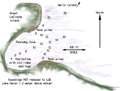
This is our second visit to Marianne Bay. (See the North Channel virtual cruise for more info on Marianne Bay .) The soundings shown on Canadian Chart 2205 make the cove look too shallow, but there is plenty of room in here for anchoring. It has about twenty feet of water in the center, and is almost that deep to shore in many places.
Last time here, we heard about a climbing trail that would take us to the top of the big hill to our east. We didn't exactly look for it on that trip, but today, with the nice cool temperatures and bright sunshine, it is the perfect morning for a climb. Off we go in the dingy to find it. Along the way we meet our neighbor, a cruiser from a Michigan-registered trawler. He directs us right to the spot where the trail begins. It starts east of the cove itself, along the shore, beyond the cottages.
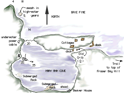
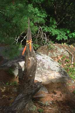
1020 We begin our ascent

Initially we hack a trail along the shore, heading eastward until
we find a red ribbon. It clearly marks a trail ascending
Frazer Bay Hill, about 575 feet above the lake.
For 10-15 minutes we climb at walking speed, our breath
getting raspy. Then some level traverse, and more
climbing. The trail breaks out of the dense forest
and into more rocky terrain.

Some steep ascents up rock walls, thru wonderful
little splits among the huge granite and quartz.
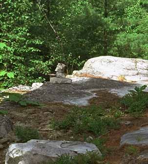
Little stone cairns replace the ribbons as we near
the summit.

1105 A short traverse and descent, then we are at the
last ascent to the top.  Up we go.
A few steep climbs...
Suddenly we are above the trees. The view
is magnificent! It is wonderful!
The highest we've ever climbed,
and the scenery is the most wonderful.
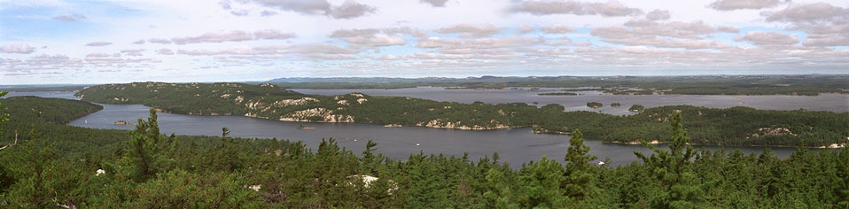
This photograph is a composite of three exposures, taken from the summit of Frazer Bay Hill, looking west, northwest, and north. The narrow entrance to Baie Fine from Frazer Bay is on the left. In the center are Birch Island and Great La Cloche Island. North of Baie Fine is McGregor Bay, with the Ontario mainland beyond. [A larger image is also available]
The air is cool again, and we
have to put back on the jackets
that we shed on the climb.
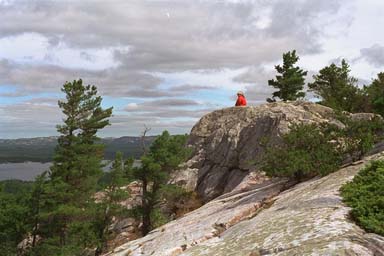
Chris relaxes at the summit of Frazer Bay Hill
The panorama is filled with islands,
sailboats, trawlers, isolated rocks and shoals,
and the La Cloche Mountains to the north.

We see McGregor Bay, strewn with shoals, rocks
and cottages, for the first time.

1130 We begin our descent. In some places,
it is harder than the climb because you
have to go down backwards.

1210. Back at the dingy. We have a row
ahead of us, a little rest for our legs
and a workout for the arms.

1220 Back aboard. We are pooped! Chris makes
lunch. It is the most delicious sandwich
in history, our hunger enhanced by
the morning's workout.

1600 Swim. The water is really not that bad,
once you are in it.

1730-1845 Boat ride (in the dingy) to visit the
northern cove, unnamed, then on to Okeechobee Lodge,
now closed.

   "CLOSED NO TRESPASSING"
   "FOR SALE"
   "NO DUMPING"

Big signs adorn the beautiful docks.

We revisit the wrong side of the red buoy--the big rocks
are still there.

1900 Salmon patties, corn, tomatoes for dinner. Excellent!

2000 Fishing: no luck. Motor runs well, then stalls
The plug probably getting fouled. We haul the
outboard back aboard the sailboat.

The darn thing leaks fuel even after I let it
run out the fuel in the carburetor. When
we set it on the deck, fuel pours out.
Bummer. Gotta fix this.

Maintenance items: Changed port jib sheet to match
starboard in size; whipped and seized ends of the
following lines:
   1. Port jib sheet, new, 2 places
   2. Port jib sheet, old, 2 places
   3. Starboard jib sheet, 2 places
   4. Long Blue line, 2 places. Also coiled this line
      in three hanks for better handling
   5. Cut off damaged end of short blue line and
      whipped and seized ends, 2 places

WEATHER FORECASTS

N Lake Huron and Georgian Bay
   Winds N 10 veering to E; fair
   Rain and Thunderstorms developing this evening
   MAFOR 12800 13200 13206

   Synopsis:
   At 2200 today, High central pressure 1025 mB
   near Sudbury; NE-SW trough Eastern Manitoba.

   At 2200 Tuesday: High central pressure 1021 mB
   eastern Quebec; Trough and Wind Shift Line (WSL)
   central pressure 1012 mB NE-SW through central
   Lake Superior.

Recreations Boating Forecast, North Channel
   Winds N 10 or less becoming variable tonight; fair
0820 WEATHER FORECAST

N Lake Huron and Georgian Bay
   Winds East 10 knots becoming NW overnight. Fair
   Chance of rain and thunderstorms this afternoon.
   MAFOR  13200 14206 11706

   Synopsis:
   At 0400 today, High central pressure 1026 mB
   over SW Quebec with ridge 1023 mB to N Lake Michigan.
   Trough and WSL 1016 mB Lake of the Woods south
   to Low 1016 mB over Northern Missouri

   At 0400 Wednesday, High central pressure 1026 mB
   eastern Quebec with ridge 1017 mB to Maine.
   Trough and WSL 1012 mB over Timmins, south to
   Low 1008 mB eastern Lake Erie

Recreational Boating Forecast, North Channel @ 0530
   Winds East 10 knots or less. Visibility reduced
   Fair; showers this afternoon and evening
The weather is clear. We put the outboard motor away last night, so we are all set to go this morning. I pull myself over in the dingy to the tree on shore where our stern line is tied and let it go. Serenity swings around on her anchor to face north. We haul the Fortress 16-pounder up without a problem, and we are off, under motor, for the narrows and Frazer Bay around nine o'clock.
The wind has hauled around to the east, so we are blessed with more downwind sailing. The diesel goes off, and main and genoa are up for a reach down to East Mary Island, and then on to Little Current. It is a very nice morning for a sail.
1230
Recreational Boating Forecast, North Channel @ 1230
   Winds East/Southeast 10 knots becoming NW
   Fair; showers today and tonight

1230 Checking compass deviation on range
east of Little Current

   TB   259
    v     9 w  (8.5 w in 1989, with 5'/yr x 8 yrs = 40' = 9 10'w)
   MB   268
    d   (to be determined)
   CB   270 observed on range

Compass deviation looks like 2w.
I make a notation on the ship's compass Deviation Table.
There is a large gathering of boats waiting for the 1 p.m. bridge opening. We charge through, the current still running west-to-east against us. Then there is a little race for a tie-up on the town dock. We are lucky to grab a spot. In Little Current, Chris takes a long, hot, shower. She has been cold ever since Frazer Bay Hill, where she got over-heated in the climb then over-cooled by the brisk winds at the top. We have lunch dockside, including one of those delicious hot-dog/sausages a local fellow sells from a cart. After 90 minutes, we are ready to continue our cruise, this time west and north to Sturgeon Cove.
FORECAST ISSUED AT 1600
North Channel: Winds east/southeast at 10,
becoming northwest and increasing to 15-20 overnight.
Showers and mist patches tonight.

1900  At anchor is Sturgeon Cove, SW corner. Only
four boats here: small boat at beach; 33 Awlgrip
powerboat at eastern end; Edel 28 sailboat just
north of us.

We left Marianne Bay around 9 a.m.
Motored from Baie Fine. Raised sail
in Frazer Bay and had a nice sail
to Little Current. The first leg,
a close reach to SE of East Mary
Island, then a nice run to the
west, wing-on-wing, using the
spinnaker pole.

Sailing Note: When wing-on-wing
you can sail by-the-lee for the
jib much farther than you can for
the main. Set the jib to the windward
side of your course.

We led a pack of four sailboats toward
Little Current. We sailed past the
Strawberry Island lighthouse under
full sail at 5.6 knots. No one
was outside to see us, unlike Saturday
when a big group was playing crochet
on the lawn.

SAFETY NOTICE TO SHIPPING

Submerged object reported at position
   45  57.78 N
  081  49.64 W

C-2289 Sunken sailboat in position
   44 47.11 N
  079 51.66 W

C-2220 Submerged sailboat 1 nm SE Hilton Beach
Marina, St. Joseph Island. Hull is visible
and marked with a life jacket.

C-1607 Drift fish net reported stuck in 42 m deep water
1 nm off nuclear power plant at Douglas Point.

RECREATIONAL BOATING FORECAST issued at 1730 EDT Tuesday

Winds east/southeast 10, then northwest and increasing
to 15-20 overnight. Visibility fair. Showers and mist tonight.
It is too bad my notes don't say if the forecast called for the winds to "veer" to NW or to "back" to NW. It would turn out to be significant. We've got the southwest end of the cove to ourselves, and we are swinging on a single bow anchor. We retire from the cockput and a cloudy sky with no stars visible to a cozy vee-berth.
We picked our anchorage in Sturgeon Cove based on the forecasted winds. When we entered, they were from the east, but overnight were supposed to switch to northwest. The eastern end of the cove is a great place to be in an east wind, but in a northwest wind, the waves can roll right in, as they have for eons while building that nice little sandy beach down at that end. So, thinking ahead, I decided to stay on the west end of the cove, where we'd be well protected from the northwest winds. Or so I thought.
I should have given more consideration about the path the winds would take in their shift from easterly to westerly. If they were going to "veer", that is, shift in a clockwise direction, they would swing through south during the night, and we'd be well sheltered. Should the winds "back" from east to west, that is, shift through north, we would be left with little between us and a couple of miles of open water other than the mouth of the anchorage. In other words, we'd be quite exposed.
The answer to this question was delivered to us about three in the morning, when we were awakend by the motion on the boat. The bow, and we in the vee-berth below, were pitching up and down several inches in the surge coming into the cove from the north.
I went up on deck to see what our position was relative to the shoreline off our stern. When I slid the companionway hatch back, I was greeted by a cold, wind-blown rain from the north, funneling under the boom tent.
"What a miserable night," I remember saying several times. It was windy and raining on deck, we were bouncing around in the small waves coming across the anchorage, and Serenity was doing her best to sail off the anchor. She'd get up a head of steam on one tack and sail for a minute until her anchor line yanked her bow to windward, then she'd come about and fall off on the other tack. She'd reach off until the anchor line pulled her up, when she'd come head to wind for a few seconds, then begin the process again on the other tack. Even with the boom tent providing all that windage aft, she would still not weather-vane on the anchor line. Instead, she did her best to sail, back and forth, all night in the storm.
Sleep was pretty much out of the question. We just lay awake in our berths, hoping that the anchor would hold. We were holding on our aluminum Fortress, a 16-lb Danforth style, at the end of about 60 feet of line and 15 feet of chain in only 12 feet of water. Serenity's rocking motion was doing a good job of digging it in, I guess.
0300  Wind up and shifting. Bow pitching in waves.
Anchor holding.

0630  Winds subside enough to sleep.
A strange line of clouds just to the north.
The front?
About this time, the wind moved a little farther to the west and we began to receive a little more shelter from it. We were able to drift off to sleep, until the LORAN began sounding its ANCHOR WATCH ALARM. I had set it earlier to alert us if we began dragging. At the sound of those electronic beeps, I came running out of the vee-berth, thinking we had suddenly started dragging anchor. That was not the case. The LORAN had decided we'd instantaneously jumped about a mile to the east, caused by an error in reception. It was quite a harsh way to wake up after only a few minutes of sleep following a sleepless night!
0900 Sun awakens us. Clear skies, northerly wind.

MARINE FORECAST ISSUED AT 0400

W Lake Superior   NW 15-20 becoming W. Mist patches. Fair
                  MAFOR 12710  12720  14610
E Lake Superior   Small Craft Warning (SCW) due to wind.
                  NW 15-20 increasing to 20-25 later this morning
                  West 15 tonight. Fair
                  MAFOR 12710 14720 19730 12610
Lake Huron/GB     Small Craft Warning due to wind.
                  Winds E 10 increasing to NW 20 late this morning
                  Showers and mist patches ending. Waves building to
                  2 meters by noon.
                  MAFOR 12206 15720
Synopsis: At 0400 today, a Low, central pressure 1010 mB, over Lake Ontario;
          High, central pressure 1024 mB western Minnesota.
          At 0400 Thursday, Low, central pressure 1005 mB southern Quebec;
          High, central pressure 1019 mB over Wisconsin.

SAFETY NOTICE TO SHIPPING

C-1997 Lake Huron/Georgian Bay. A submerged object reported in position
        45  57.78 N
       081  49.64 W

C-2318 Georgian Bay/Meaford. Unlit barge in position
        44 47.400 N
       079 51.950 W  Abeam Snake Island

Green Spar Buoy "E11" partially submerged and appears to be sinking.


1100-1230  Fishing. Excellent results. Three fish:

      1. Big smallmouth bass, over 2 lbs, south shore between
         gov't range and GLCC range.
      2. Little smallmouth bass, along western shore
         ---both above on Rapala minnow, perch colors---
      3. Northern Pike, 30-inches or more, east of gov't
         range near south shore, on Red/White daredevil.

1255 RECREATIONAL BOATING FORECAST - North Channel
     Winds NW 15-20 decreasing to West at 10 or less tonight
     Visibility good.

2040 Listening for weather forecast.

Notes on Sturgeon Cove anchoring.
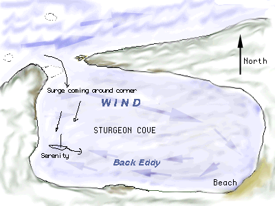
Serenity is lying to easterly eddy in anchorage, and
rolling to swell coming around the corner.

MARINE FORECAST

Lake Huron   Winds NW 20 decreasing to 15 by midnight,
             and to west 10 on Thursday morning.
Synopsis: At 1600 today, Low, central pressure 1006 mB north of Ottawa;
          High, central pressure 1020 mB over souther Minnesota.
          At 1600 Thursday, Low, central pressure 1005 mB eastern Quebec;
          High, central pressure 1017 mB over Lake Erie.

RECREATIONAL BOATING FORECAST FROM ENVIRONMENT CANADA
REGIONAL WEATHER CENTRE IN OTTAWA ISSUED AT 1730 EDT
13 AUG 1997. NEXT FORECAST AT 0530 TOMORROW.

NORTH CHANNEL  Wind NW 15-20 decreasing to W at 10 or less
tonight. Wind shifting to east late Thursday. Fair

SAFETY NOTICE TO SHIPPING
C-2333 Georgian Bay   Ann Long Bank buoy E11, list of lights
number 979, laying on her side and possibly adrift.

Maintenance Notes: Removed defective florescent light and defective
incandescent light from cabin bulkhead port side. Repaired switch
and lamp socket, and re-installed incandescent lamp, cleaning up
the wiring in the process. Fixture still has an intermittent connection
buried inside.  Need two new 12V bulbs.
MARINE FORECAST
Lake Huron Winds NW10 backing to SW afternoon and increasing
to S 15-20 late tonight. Fair. Chance of showers after midnight.
Synopsis: At 0400 a High, central pressure 1018 mB over southern
Lake Michigan; NW/SE trough thru western Manitoba.
At 0400 Friday, High central pressure 1016 mB over eastern
New York state; a Low, central pressure 996 mB over
southern Manitoba with a through central Wisconsin.
RECREATIONAL BOATING FORECAST
North Channel Winds west 10 knots becoming southwest and increasing
to 15 overnight. Fair. Risk of showers and thunderstorms overnight.
1030 Departing Sturgeon Cove. High water makes the lower range mark
of the [diamonds] hard to see. It is awash. Backlighting by
the sun obscures the [triangle] mark in the tree. We leave
on memory.
1130 Coasting up the northwest side of Wells Island. Our chosen
anchorage cove had a surge in it. We try farther up the shore,
but a big swell is running off the bay. We retreat.
We stop for lunch in a small cove, just south of the main channel
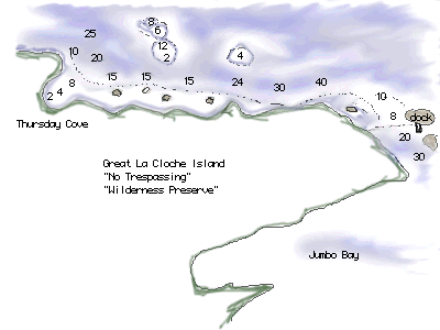
on the north side of Great La Cloche Island.
It ends up being our final stop.
We take a dingy trip down the shoreline to the east, to peek
into Jumbo Bay. The wind is strong, and the return trip is
wet.
Dinner, then a final boat trip into an even better protected cove,
follow.
0200  Rain, wind light from the SE. We have swung around on the
anchor to face SE.

0700  Up early, and thankful for no fog. Visibility good.
Coffee exhausted!

RECREATIONAL BOATING FORECAST AT 0530
Wind SE veering to S. Periods of rain.
Let me continue the story. We haul the anchor after a short cup of coffee, and motor out of the anchorage, which is delightfully well protected from the southeasterly breeze that is building. Once west of the narrows between Wells and La Cloche Islands, we unfurl the genoa for some more downwind sailing. We are easing along the north shore of La Cloche, in its lee, on a nice southeast breeze. I know that once we reach the western end of the island and turn to the south in the Wabuno Channel, we'll be in for much higher winds.
By ten o'clock we are just turning the corner between Halfway Islands and La Cloche, and it is time to reduce sail. Soon we are down to just a small triangle of a headsail, and we are close-reaching down the Wabuno Channel at speeds as high as 5.5 knots, bucking into a stiff breeze from the SE. We are making a lot of leeway with this configuration, so about three-quarters of the way south in the channel, we douse the jib and turn on the motor. By this time, the winds are so strong that it is very difficult to get the rest of the sail furled. It is almost at the point of needing a winch to crank it in, but I finally do manage it by hand, with some big heaves on the small-diameter reefing line.
The old 2QM Yanmar diesel shows her strength as she punches Serenity into the teeth of the wind and waves, now up to 25 knots and five feet respectively. We are heading east toward Spider Bay Marina. I hail them on Channel-68 to inquire about room at the fuel dock. "Come right in," they respond. There are not many other boats out in this weather.
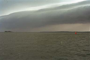
As we enter the narrowest, buoyed part of the channel, I turn around to glance behind us. Wow! A big, dark cloud looms on the horizon to the west. It makes a great picture.
As we turn into the Spider Bay Marina channel, the wind suddenly dies. We are in complete calm. Expecting to be slammed against the fuel dock by the ragging east wind, we instead have to motor over to it. It is uncanny how the wind has stopped. For ten minutes we take on water and diesel fuel, and pump out our holding tank. Then we back off the dock against a northeast wind, now, and motor to our assigned slip.
A few minutes after we are safely secured in the slip, the wind switches quickly to the west and begins to blow again. By 11:30 a.m., the wind is all over the compass, and the rain begins. It is a heavy, steady rain that lasts for eight hours! It just rains and rains all afternoon! With the exception of about ten minutes, it rains continuously until 7:30 p.m. Water levels in the marina, already very high, jump another couple of inches.
It is a soggy finish to a week of cruising that has seen the most rain we've ever encountered in the North Channel. Even all the moisture, however, cannot dampen our spirits. Cruising the North Channel remains a wonderful tonic for the soul, and we have refreshed ourselves for another year. Friday night's dinner is at the newly re-opened Shaftsbury Inn, a reprise of our first dinner together on Manitoulin back in 1986. It fittingly completes a circle that has taken eleven years and twenty weeks of cruising to navigate.
We've had another great week, and we look forward to our next visit to these magical shores.
This article first appeared November, 1997.
Copyright © 1997, 1998, 1999 by James W. Hebert. All rights reserved.
This is a verified HTML 4.0 document served to you from continuousWave
URI: http://continuouswave.com
Last modified:
Author: James W. Hebert