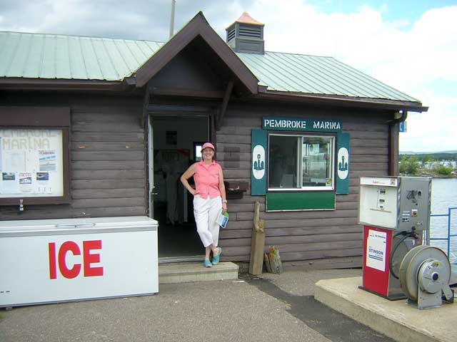
The Marina Office at Pembroke, Ontario municipal marina. The fuel was moderately priced, the ice was cold, and the staff was courteous.
The waterborne portion of our trip begins.
| Date: | Sunday, July 23, 2006 |
| Weather: | Warm and sunny |
| Winds: | Light |
| Traffic: | Rural highways with no travellers |
| Departure: | Lake Dore |
| Destination: | Pembroke, Ontario, thence to Deep River |
| Distance: | 25 miles by highway; 41 miles by boat |
Aunt Laurel sends us off after a late breakfast of eggs, sausages, and country baked bread. We take the county highway north to Pembroke, a city of 15,000 on the shore of the Ottawa River. Navigating by the provincial highway map, we do not have much detail, and we depend on signs to direct us to the marina. We miss a crucial turn, and have to double back. As we are nearing our launch, I am keeping track of gasoline stations. We need one to fill the boat's 77-gallon tank just before launching. Gasoline is always less expensive on the highway than at a marina, and the quality of the fuel is generally better, too.
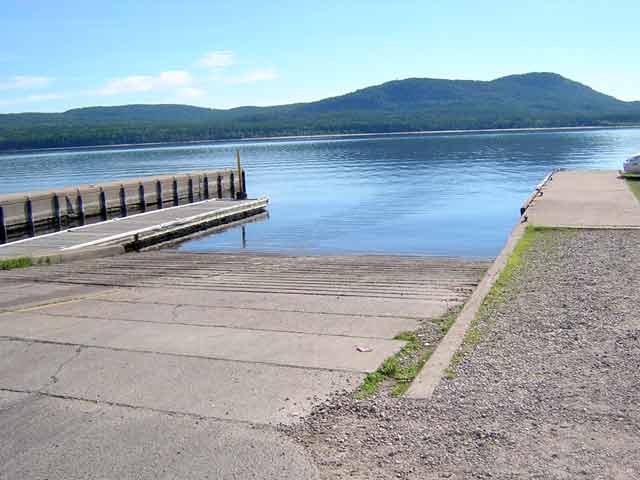
Eventually we locate Pembroke's municipal marina and boat launch. It is just a few blocks from a gas station with broad lanes and many pumps, which is exactly what you need when you have a large boat in tow on the trailer. We have to pass by many stations because it would be too awkward to drive into them with the boat. This station is perfect, and the price is moderate, too. Here gasoline is about CA-$1.09/liter. We add $200 of fuel to the boat, which puts the mechanical tank level gauge past the FULL mark. As the gas station is under a nice canopy which shades us from the sun, we also do a lot of boat preparation for launch, including putting up our Flying Top to provide more shade.
Back at the marina, we pay the $6 ramp fee and await our turn. There is a boat already launched but still tied to the courtesy dock right at the bottom of the ramp. Its owner is not aboard, but a couple of passengers are. While we wait for the skipper to clear the ramp, we continue with our preparations. After about fifteen minutes the absent skipper returns and clears the ramp. We are not in a rush--it's our vacation and we do not have far to go today. So the delay has not been an annoyance. We back the boat down the long ramp for launching.
The actual concrete portion of the ramp extending into the water is narrower than the approaching ramp. We discover this once the other boat has left the courtesy dock. Chris waves me off as I try to back in. "You're too close to the edge of the ramp," she informs me.
I have to pull up about a third of the way on the ramp and try it again, angling the boat away from the courtesy dock and toward the concrete underwater ramp. As the trailer goes into the water, we discover a second problem: this ramp is very shallow. With the truck nearly at the water's edge, the boat is still several inches above the float line I have marked on the trailer guides. It is going to be a bit of a problem to get the boat off the trailer here due to the shallow ramp.
I pull the trailer out of the water so I can try it again. This time I will back in faster and come to an abrupt stop. The momentum of the boat should carry it off the trailer bunks far enough to get the hull into the water and floating.
(After I pulled up the ramp, I realized that I had not secured the winch strap! I could see the boat was rocking a bit on the bunks. This gave me a momentary scare, as I had a vision of the boat suddenly sliding off the trailer! It is never a good idea to pull UP a ramp without securing the winch strap to the bow eye! I will try to keep that more firmly in mind in the future.)
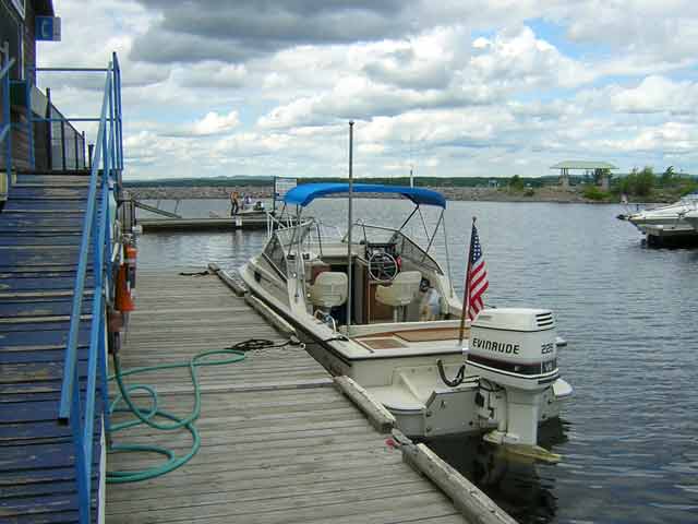
The third time is the charm, and the boat slides off the trailer bunks and into the dark tannin-stained water. Chris handles the lines and reels the boat into the courtesy dock. I immediately exit the ramp area and drive over to the trailer parking.
Trailer parking is quite a hike from the ramp, and even at a jog, it takes me a couple of minutes to get back to the ramp. I get the engine started, and turn our attention to some other preparations as it warms up. There is a short T-dock at the end of the ramp, but it is full with boats which have already launched but not departed the ramp area yet.
Literally a minute later we are just about to cast off when a local boater comes down the ramp to inform us, "I am just about losing my patience with you."
I am taken aback by his complaint. We've waited over 15 minutes for an absent skipper to get his already launched boat off the ramp. And the rest of the courtesy dock is taken with boats which launched 20 or 30 minutes ago and still haven't moved. We've been in the water for all of about five minutes. Perhaps our complaining local pulled up just in time to see our three-tries at launching.
"I'm sorry," I explain, "but we've never used this ramp before and it was rather shallow for our boat. We'll be right out of your way."
I shift into reverse and pull out from the ramp. We head over to the fuel dock to really top-off the tank and get some ice for the cooler.
I have learned that the launching ramp is a scene of high tension, and it is much better to suffer rude behavior in silence than to provoke even more with a challenging remark. So far our initial reaction to Pembroke has been neutral, but this fellow's remarks have put us on edge.
The young attendants at the fuel dock are very courteous. We take on more fuel, just enough to really top-off the tank so that I can mark the level on my NAVMAN 3100 fuel flow instrument to be "70-gallons". The tank is actually rated to hold 77-gallons, but I feel more comfortable measuring down from a 70-gallon mark on my electronic level gauge. We add ice to the cooler at reasonable prices, and we also make a telephone call to our destination marina at Deep River. They have dock space available, although they only have three slips for transient boaters.
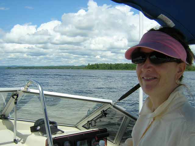
Chris goes back to the truck for some last minute items, and also visits the marina wash room facilities, located between the marina and the parking lot. When she is back, we seem ready for our trip to begin. We cast off and head out into the Ottawa River at Pembroke, into Lac Des Allumettes (Allumettes Lake). The river forms the border between Ontario and Quebec, and many of the place names have a French heritage, as do many of the residents.
This is all new territory for us, so we are paying close attention to the paper navigational charts we are carrying. Our electronic chart plotter does not have any cartography for this region. We have become spoiled on our last several trips by the automatic position finding and display of our GPS and Chart Plotter. Now we have reverted to Canadian Small Craft Chart 1553 and deduced reckoning as our primary navigation tool, aided by GPS position fixes.
The marina entrance channel is marked with paired red/green lateral buoys, and soon we are into deep water. As it is Sunday afternoon, there is other boat traffic in the area, and this provides a clue to where to go. We head upstream, following several other pleasure craft heading in the same direction.
The weather is delightful. It is a beautiful sunny afternoon with temperature about 30-degrees-celsius. There are some clouds overhead, but they look like fair weather cumulous. The boat is running beautifully. Even with the heavy load of all of our gear, coolers, ice, and full tank, it gets up on plane and runs very nicely.
About ten miles upstream from Pembroke, past Petawawa, we stop for lunch and drift in the lee of the river current east of crescent-shaped Pearl Island. Chris whips up a fine lunch from the cooler, and after enjoying the meal, we are giving some serious thought to taking a dip to cool off.
"We forgot the swim ladder in the truck," announces Chris. She is right. The darn swim ladder was in the back of the Suburban, not on the boat. We ponder the situation for a minute. As we learned last year, it is just about impossible for either of us to get back aboard the boat from the water without the swim ladder unless the boat is in very shallow water.
"It is a twenty mile round trip to go back and get the ladder," I suggest. It costs about $2/mile to move the boat, so there is a $40 expense to go get the ladder. I present this to Chris for consideration.
Ultimately, we decide that it is more of a safety consideration to have the swim ladder aboard. Our ladder is not really worth $40, but we are going to go back and get it. And there is no question that we will enjoy being able to swim from the boat at some time during the week.
We head back to Pembroke for the ladder. In the process I manage to leave buoy K66 on the wrong side. Fortunately, it was located far enough away from the 2-foot shoal it marks that we passed it without incident. The river water is rather dark from all of the lumber which has been carried on it in two centuries of logging, and it is difficult to read depths. As we passed close abeam the green buoy, I did notice the depth sounder was reading the bottom a bit closer than usual. (This sloppy piloting was unfortunate, and we were lucky. I did not realize, at the time, that I had left the buoy on the wrong side. This revelation would come a few minutes later.)
To shave a mile or so off the return trip, I take the option to pass south of Cushing Island. About a mile from Pembroke I notice we are again in some shoal water--4-feet! A quick look at the chart reveals that there is a broad hump off this point of land. I should have been farther offshore. Navigating in strange waters always requires vigilance! (Lucky again.)
Back at Pembroke, Chris makes the trek over to the car and returns with the swim ladder. She also brings a couple of other items we had left, including her iPod. As we are not too sure about fuel provisions further up the river, I decide to top the tank off, again. This time we are able to add ten gallons. Marina fuel was a bit more expensive than the highway, but not outrageously priced. We cast off and repeat our voyage upstream.
Our luck with the weather is not holding. Now that we have the swim ladder with us, the weather has ironically turned noticeably cooler, and dark clouds are coming in from west. An hour ago we were in shirt sleeves and now we are putting on our fleece jackets to stay warm. We are not more than two miles from Pembroke when rain starts to fall. We have to stop and put up our windshield and side curtains to keep from getting drenched!
Approaching K66 from downstream, again, I realize my error of forty minutes ago. What lured me toward the wrong-side pass was the huge tower that is located just north. This aid is charted as a white flashing light marking the north end of Short Turn Island, so it is not part of the lateral buoyage system. Unfortunately there is a catwalk at the top which is painted red, and, glancing at the light, it led me to interpret it as a red day mark. Having just left it to starboard, I was lured to leave green K66 to port. That's the wrong side.
Studying the chart I announce, "Oh, man, I took that buoy on the wrong side on the way back! Are we lucky." "There is a two-foot patch over there," I say, gesturing to port.
We make it safely back to Pearl Island, and resume our trip upstream. In another mile we leave K68 to starboard, and we can clearly see the shoal as on the sand bar there are several boats anchored with owners standing next to them in knee-deep water. That is about the last buoy in this stretch of water. After this, the Ottawa is deep and clear, and you just head down the middle. The rain has let up, but the sky is still overcast and dark clouds are scudding in.
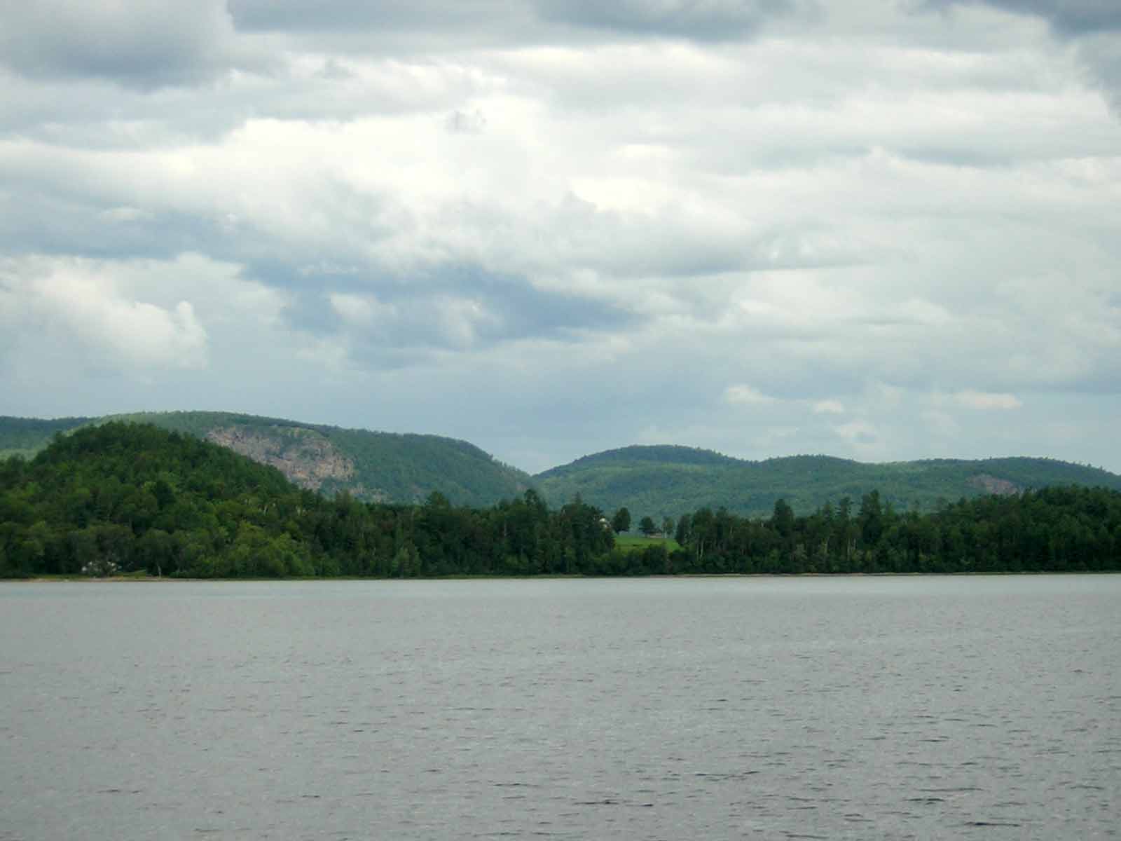
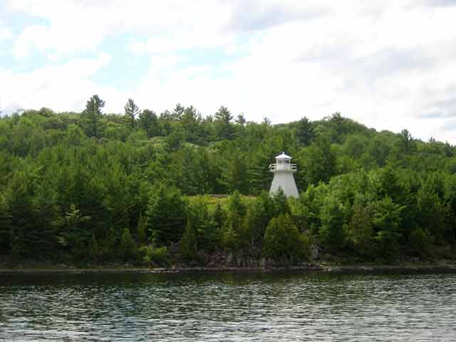
At Pointe Malin on the Quebec side, Lac Des Allumentes ends and we officially enter the Riviere Des Outaouais (Ottawa River). The northern shore is quite steep-to, and for the most part not developed at all. This turn is marked by a prominent lighthouse on the Ontario shore at High View. Along this portion of the river the southern shore is either part of a military base or an atomic research center, and numerous signs and buoys inform to keep out.
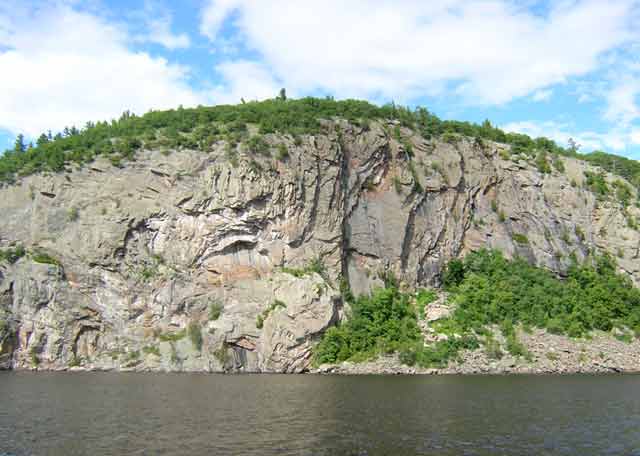
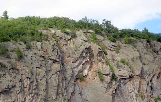
At Pointe a Oiseau we find a large collection of boats rafted together and beached on a sandy point. As we pass the point, the massive outcropping of Oiseau Rock (Rocher Oiseau) comes suddenly into view. It is a beautiful shear rock face that drops 450-feet vertically to the river. Ancient pictographs painted on the rock centuries ago with red ochre are now obscured with obnoxious modern spray painted graffiti.
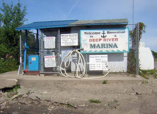
The river narrows from its 3/4-mile width to pass the Atomic Research Centre at Chalk River on the Ontario shore. The shoreline is marked about every 50-feet with warning signs to stay out. About three more miles upstream we arrive at our destination for today, Deep River.
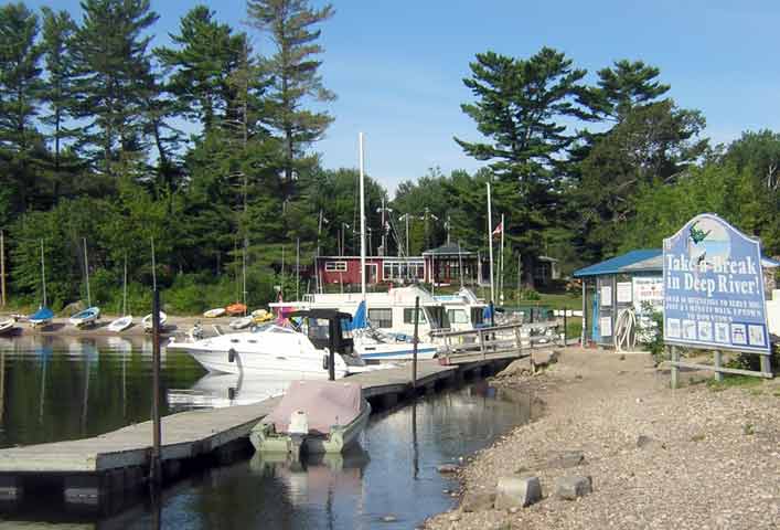
The sun comes back out as we approach Deep River, a small town built between Trans-Canada Highway-17 and the river shore. They have a nice marina behind a stone break wall, and there are about fifty small boats docked there, mostly daysailers, fishing boats, and houseboats. The public dock and transient slips are right at the entrance and exposed to passing boat wakes, but it looks unlikely there'll be much traffic after dark. We enter at idle and hail a fellow on the dock who directs us to our slip. The docks are floating, and the finger piers are very unstable. If you venture out from the centerline of a finger pier the deck tilts until one side is awash!
"These finger piers are a bit tippy," I comment to the fellow, whom I think is the harbourmaster.
"Yes they are," he says, "we lost three boaters last weekend on them."
After we get acquainted, we discover that the fellow we've been talking with is just another transient boater, but one with a sense of humor. He's voyaging downstream on an ancient wooden cruiser, powered by a 1952 Gray Marine inboard engine. The boat is not in Bristol condition, and its plywood cabin sides are de-laminating and haven't seen a fresh coat of varnish in a long time. In the cabin window there is a very official looking sign that says, "Property of the Atomic Energy Center--Keep Out."
"You can't be serious about that sign," I say, stretching my hand toward it as I stabilize myself on the tipping deck of the fuel dock.
"Naw, that's just a joke. We found the sign on the beach, and thought it would be funny on this boat." He is right--the sign is very out of place on the old boat and quite humorous.
A few minutes later he fires up the old Gray Marine engine, and, with a cloud of smoke, slowly motors out of the marina and on his way downstream.
Eventually Chris locates the dock master and makes arrangements for our overnight docking. The fee is very modest, about US-$10. The marina does not have a bath house, but as its guests we can use the facilities in the adjacent tennis club. We get a key to let ourselves in after closing. The showers and bath are very nice, and just a short walk up the beach from the marina docks.
By 7 p.m. we have settled in and strike out on foot for some dinner. In downtown Deep River our prospects do not look too good, unless you like Buffalo Wings at the bar. We consult with some locals on foot, and hike up a big hill toward Highway-17. The sun is back and the day is warm again. We make it up the hill to the highway and traffic light. There are more choices for dining up here: a couple of fast-food chain places, a few local eateries. We decide on the Bear's Den, a restaurant associated with the local motel. (Bear's Den Lounge & Motel, (613) 584-9795, 5 Highway 17 W, Deep River, Ontario) It is a warm evening, and after the uphill walk we can use some air-conditioning.
The restaurant at the motel is almost full--and that is always a good sign--so we are glad to be seated right away by our young Canadian hostess. There is a wide selection of meals available; restaurant menus that offer so many choices make us nervous, as it can't be possible to have all those ingredients available locally and fresh. Using a bit of caution we both select the fish-and-chips lunch portion, only after finding that the Perch Dinner was not available.
The meal is promptly served and is decent, although it emphasizes the fried nature of its preparation. The beer is cold, albeit expensive ($3.75 for a bottle--we can get a six-pack for that price in the States!)
The walk back to the boat is downhill and more direct, and soon we are enjoying our first night out on the boat. As guests we have several dozen mosquitoes in the cabin. After an hour of mosquito-killing, it looks safe to turn out the lights and go to sleep.
The nine-day narrative continues in Day Three.
Copyright © 2006 by James W. Hebert. Unauthorized reproduction prohibited!
This is a verified HTML 4.0 document served to you from continuousWave
URI: http://continuouswave.com
Last modified:
Author: James W. Hebert
This article first appeared August, 2006.