continuousWave--> Sail-Logs --> Ottawa River 2006 --> Day Four
A restful day relaxing in Mattawa.
DAY FOUR
| Date: | Tuesday, July 25, 2006 |
| Weather: | Rain, turning to warm and sunny |
| Winds: | Light |
| Waves: | Calm |
| Departure: | Mattawa |
| Destination: | Local |
| Distance: | 5 miles by boat |
This morning in Mattawa is a cool and misty affair. The weather system that has brought all of the rain is still working its way through the Ottawa River valley. We relax on the boat, have an extra cup of coffee, and catch up on our reading.
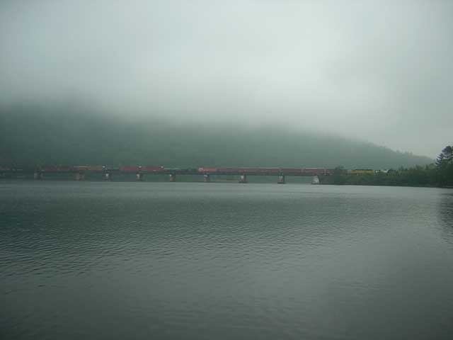
The morning train. About four trains a day cross the long trestle spanning the Ottawa River. Most of the northbound consist is logs being hauled to a mill in Temiskaming on special flat cars. Southbound trains are probably full of pulp paper. A low mist and fog hangs over the river on this morning in July.
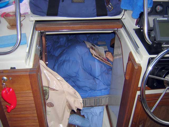
Chris stays down in the cabin on mornings like this. I keep making coffee and handing down fresh cups. The bedding has been color coordinated with our Pacific Blue Sunbrella boat canvas. We have also fabricated our own filler panel that connects the v-berths and turns the cabin into one large, queen-sized berth.
Trip Planning
When Chris originally planned this trip, Mattawa was thought to be our farthest reach upstream on the river, and she ordered the navigation charts (1553 and 1554) which we have onboard that cover in fine detail all of that portion of the waterway. We reasoned that if our schedule and progress permitted us to go further, we could purchase the charts needed along the way. We are here in Mattawa a bit ahead of schedule, due in part to our decision to skip past Deux-Rivieres as a stopover, and by our more rapid passage yesterday in the rain. Had it been a beautiful day we probably would have gone slower and stopped to explore more points of interest along the shore.
The office at the marina does not have the chart (1555) for the next reach on the river, which covers the 35 miles from here up to Temiskaming. And several telephone calls to other boating-oriented businesses in the area reveal that the desired chart is not to be found. No one even seems to have a copy of it they might let us just look at to become familiar with the waters. This situation may have been due in part to Chart 1555 being on back-order from the government publishing agency. I suspect that perhaps it was being updated to metric dimensions for the next printing, and this was holding up delivery.
At first the lack of Chart 1555 being available here, locally, seems very strange, however, as I learn more about the hydrology of the river and the placement of dams, it begins to make more sense. At Mattawa there is a nice marina and a public launching ramp, but above the Otto Holden dam a few miles upstream, there is no public launching ramp for Lac La Cav (Cave Lake). The locals would have to pay the $50 portage fee to be transported around the dam, then another $50 to come back, and apparently not many of them are motivated to explore those waters.
We tend to be prudent mariners, and we don't generally run our boat in strange water for which we don't have good charts. Without Chart 1555, we are in a quandary on how to proceed. We think this over as we wait out the lousy morning weather. There is a good breeze coming up from the west, and the low clouds are beginning to move to the east. This should bring better weather for us.
Late in the morning the sun begins to appear from the overcast skies, and not long after our sailboat companion DEPART NOUVEAU motors into the marina. He spent the evening in Deux-Rivieres, so we de-brief him to learn some details about that town. He tells us there is a small dock there which has room for four boats, and that he was able to find a hot meal. He also was able to get some gasoline, but I believe he had to carry his tank up to the highway for filling.
He plans to continue and makes arrangements for the portage. The haul-out location is further upstream, just below the dam. After a short pause, he casts off from Mattawa and continues his voyage.
We still have not come to a firm decision about how to proceed, and we just take it easy at the dock for the rest of the morning. After all, it is our vacation and we are entitled to a bit of relaxation.
By noon the sun has overwhelmed the clouds, and it is a fine day in Mattawa. We've decided we'll hang around here today, and return to our river passage tomorrow. We hike over to the Mattawa historical museum adjacent to the marina for a visit. This small-town museum has a very excellent collection of historical artifacts, and we spend an hour or more in its two-storey exhibit. Mattawa has been around for a long time--Europeans arrived here 90 years before they got to Detroit--and its location on the river, the railroad, and the highway has made it an important player in the region.
Hydrology of the River
Since I don't have a long passage to narrate for today, I will describe in more detail the upper Ottawa River and how it has been shaped by dams into the present day waterway consisting of four different levels and lakes. The river is thought to have been created 11,000 years ago after the retreat of the Wisconsin glacier. It ran its course unaffected by man until early in the twentieth century. About 100 years ago the first dams were built. The River's potential to provide hydro-electric power was well understood, but owing to its location as the boundary between two provinces, Quebec and Ottawa, political battles may have slowed any development for that purpose. Finally, in the 1940's agreements were reached among all parties--national, provincial, local, and private--and construction of several large hydro-electric generating stations and dams was begun. World War II intervened, and it was not until the post-war period that any major work was completed. By the mid-1950's the projects were finished, and the river had its new profile.
Lake Temiskaming
The headwaters of the Ottawa are about 150 miles north of us, near New Liskeard. The reach from there down to the town of Temiskaming formed Lake Temiskaming, which is a 113-kilometer (71-mile) stretch of navigable water. Historically there was a rapids at Temiskaming, which required a portage. Around 1911 a public dam was built there, not for hydro-electric power but to help control river levels and flooding downstream. There are now boat launch facilities above and below the dam, and the Temiskawa Waterway provides portage service around this obstacle. Because this is a public works dam, I believe the ramp facilities are available for public use.
Lac La Cav
Below the rapids at Temiskaming the Ottawa flowed south toward Mattawa, and the surrounding terrain became more steep and gorge-like until the river fell rapidly through La Cav rapids. The Otto Holden dam and generating station were built at the site of La Cav rapids. Construction was finished c.1950, and the dam backed up the water of the river into a large reservoir, Lac La Cav. The level at Lac La Cav is typically maintained at about 175-meters (574-feet) above sea level, producing a 22.7-meter (71.5-foot) head of water in the reservoir for power generation. There are 56-kilometers (35-miles) of navigable water above the dam, extending to the north to the town of Temiskaming.
From what I can tell, there is not much public access along the shore of Lake La Cav at the southern end. The boat ramp just below the dam is on the property of the power company, and I presume the ramp above the dam is also private. The only way onto the reservoir is thus via the portage facility or from private property along the shore. I hope to learn more about this stretch of the river when we eventually transit it via boat someday. You can, of course, launch below the dam at Mattawa's public ramp.
Otto Holden Lake
About two miles below the Otto Holden Dam the Mattawa River flows into the Ottawa. Here the water level is typically around 152.3-meters (502.5-feet) and is more or less at its historical level (I presume). The original river then flowed south and east through a steep sided gorge, with significant rapids in several locations along the way, until it reached Rapides-des-Joachim, which were described as being among the most spectacular in all of Canada. In 1942 work was begun to build a very large hydro-electric generating station and control dam at Des Joachim. Construction was finished c.1948, and water began backing up to form the Otto Holden Lake reservoir. The typical summer level of the lake is 152.15 meters (502.4-feet), while the Ottawa River below it is usually around 111.3-meters (365.2-feet). This creates an enormous head of water for the dam, about 40.85-meters (137.2-feet). The power of this falling water produces a half-million horsepower which in turn is used to generate about 360,000-kilowatts of electricity.
The boat ramp below the dam in the town of Des Joachims appears to be available for public use, but the ramp above the dam does not. However, there are several public ramps along the southern shore of the lake. There is a nice facility right on the highway at Mackay, as well as one at Deux-Rivieres (I presume). There may be other, small ramps used by local boaters, too.
Ottawa River and Lake Alumettes
Below Des Joachim, the Ottawa flows at a more natural level, running down to Deep River, Petawawa, and Pembroke, and into Lac du Allumettes. The river's course narrows at Cotnam Island, and the Rapides des Allumettes restrict the flow into Lower Allumettes Lake. Downstream from there are more rapids and dams, until the river joins the St. Lawrence and flows to the Atlantic. This reach is outside of our concern on this trip.
Water Levels
While sitting in the boat cockpit, I glance up and notice a wave train of small, six-inch, wavelets coming down the river. There had been no boat traffic passing by, so the source of these waves had to be from the dam itself. Apparently there had just been a release of some water from the dam, probably associated with more generating capacity being brought on-line. After checking with the dock master, it is confirmed. There is a diurnal water level variation here of about three feet. I deduce that this is related to hydro-electric generating output. Overnight, as electrical demand decreases, water is held back in the reservoir and the level at Mattawa drops. As electrical demand increases, more water flows through the generating plant, and thus the water level tends to increase during the day. By late afternoon when electrical demand is peaking, water flow through the generating station is at its peak, and thus the water level here at Mattawa will be at its highest for the day. The level can vary as much as 1.5-meters (4.5-feet), so the need for a floating dock system is clear.
Local Boating
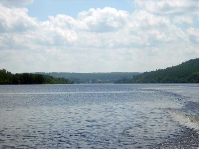
In the early afternoon the weather has returned to a glorious summer day, and we must go for a boat ride, even if we are not going on a long journey. We cast off and head upstream to see what the remaining portion of the river looks like below the dam.
The water in the river here is quite dark and stained with tannin, as it has been all along our course. This makes it harder to see shoal areas by eye, so we depend on our chart and our depth sounder. A ways upstream from Mattawa I turn around to capture the view as it might appear to a relieved Vouyager who just made the portage around the rapids.
Mattawa, Ontario. The Hudson Bay Company founded a post here in 1837. The population grew steadily until the 1960's. It has recently been in decline. Curiously, the dock master, a young fellow, told us he just moved up here from Windsor, Ontario, near our hometown of Beverly Hills, Michigan. The entry of the Mattawa river from the west made it a natural location for development.
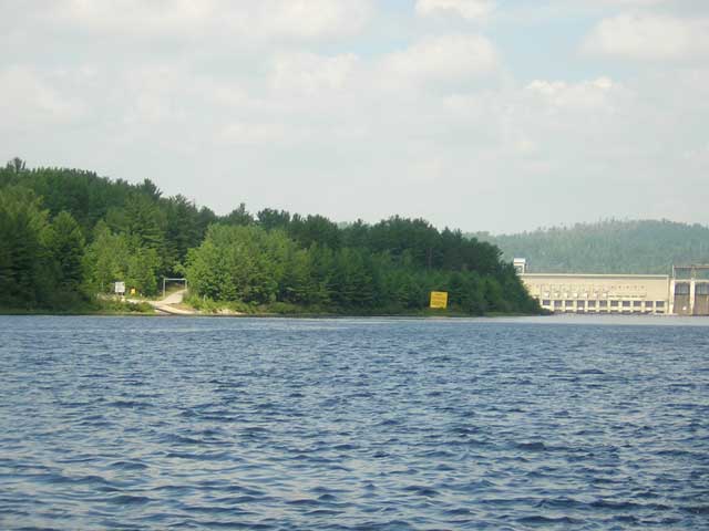
It is just a mile or two up the river and around the bend, and the Otto Holden Dam comes into view.
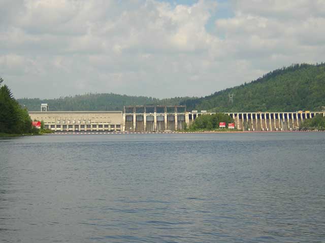
Otto Holden Dam. This hydro-electric generating station and dam have been producing power since the early 1950's. Prior to that the river was not navigable at this point due to La Cav Rapids.
To portage around the dam you moor at this dock and await the portage agent and his trailer.
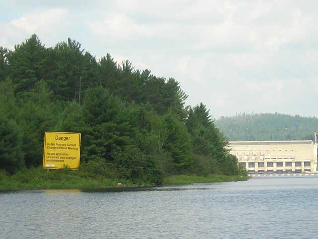
Mariners are advised "Do Not Proceed/Current Changes Without Warning."
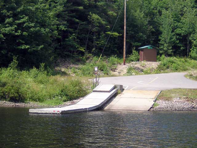
This private boat ramp has no parking for trailers. There is just a small turn-around circle and an outdoor toilet.
After concluding our brief exploration northward, we cruise downstream and pick a nice spot to anchor. The river generally carries deep water to the shore in this area, but north of the large unnamed island we find a shoal where we can hook up in less than 4-meters (12-feet) of water. We spend several hours relaxing in the solitude of the river. This includes going for a swim. Having invested $40 in fuel to get the swim ladder aboard, we are damn well going to use it! In the late afternoon a roar comes down from the close-by Quebec shore as a crew begins to clear downed timber from along the railroad right of way. Our tranquility disturbed, we haul anchor and go back to the dock in Mattawa.
On the way back to our marina berth we stop at the fuel dock to top off our tank. We were expecting the gasoline to be a bit more expensive at the marina than on the highway, where it is selling for about CA-$1.10/liter, but we were not prepared for the shock at the pump. The marina sells their gasoline for $0.608/half-liter, or CA-$1.216/liter. This converts to about US-$4.20/gallon, a new all-time high for boat fuel. We take on about $160 of gasoline, which should be enough to get us back to Des Joachim with a comfortable margin. This leaves us with about 60-gallons on board.
By this point in the day we have more or less made up our minds about continuing farther upstream: we won't do it this trip. We'll leave it for another adventure in the future. We don't have the charts, and with two portages needed to navigate the next 35 miles, we will have $200 in portage fees. Instead we plan to begin our return trip downstream, which we hope will give us a day of fine weather to explore the shores of Holden Lake down to the Des Joachim dam at a leisurely pace. With that settled, we turn our attention to dinner. We need to find another restaurant in Mattawa for this evening.
After consulting further with some locals, the vote is in, and it is unanimous: the best restaurant is Myrt's, located on Highway-17. It's a long walk, but it will be worth it, even on this hot summer night, which back here on land seems even warmer. The directions to Myrt's:
- From the marina docks at the river, walk (uphill) about 0.1 mile to the highway.
- Walk (uphill) 0.1 mile to the bridge across the Mattawa River
- Walk (uphill) 0.2 mile into town.
- Walk (uphill) 0.1 mile to the intersection of Highway-17
- Walk (uphill) 0.5 mile on Highway 17 to the top of the highest point of land in the town of Mattawa, now about 400 feet above the river.
- Walk (downhill) about 100 feet to Myrt's Restaurant
At Myrt's we find the parking lot filled with cars and the dinning room crowded with locals having dinner. This must be the place to eat in Mattawa. We enjoy a modest meal, and we really enjoy the air conditioning.
"This must be one of the five nights all summer that you need air conditioning in Mattawa," I say to Chris. It probably accounts for the large crowd on a Tuesday evening.
After dinner we head back to the boat. Fortunately, after a very brief climb to the summit of Mattawa, it is all downhill from there. At the summit there is a beautiful old stately home. Its grounds are a mess of toppled trees, most of them very mature and very old growth. They were lost to the freak storm that rolled through town last week. It will cost a fortune to remove all of the trees, and a small army of men with chain saws is at work on the job.
The nine-day narrative continues in Day Five.
Copyright © 2006 by James W. Hebert. Unauthorized reproduction prohibited!
This is a verified HTML 4.0 document served to you from continuousWave
URI: http://continuouswave.com
Last modified:
Author: James W. Hebert
This article first appeared August, 2006.