![[Photo: Sleepy marina]](images/departLC512x286.jpeg)
At quarter-past seven in the morning, only Larry and Lynn were up to see us off.
0630 The forward shelter on Tom Birdsey's Outrage-18 has been a comfortable berth for me overnight. I crawl my way out and start preparing for the long trip back to Tobermory.
Before retiring last night, I checked the weather forecast. The radio is calling for light winds overnight becoming westerly and building to 15-20 knots. This morning it is dead calm at the moment. A perfect time to get underway.
Soon Tom comes down and we at a look at the status of the power trim and tilt motor on his 150-HP Mercury outboard. Tom is a little concerned that the trim should be able to be adjusted; I am thinking more like let's just get it into a decent position and leave it there. Overnight a soaking with WD-40 has removed most of the burned carbon residue that had built up from some arcing in the connection. With the surfaces fairly clean, the connections seems to have arc-welded themselves back together. The trim is working again! We are not 100% confident in it, but it will have to do. It is going to take a couple of hours to rewire it eventually; if we are lucky it will hold for the rest of the trip the way it is now.
0717 We load the boat down with all the gear that four people can carry for a weekend, and Tom's wife, Karen, and son, Scott, come aboard. We are ready to depart. We idle slowly past the rest of our fleet, still secure in their slips at Spider Bay Marina.
|
|
|
Bon Voyage At quarter-past seven in the morning, only Larry and Lynn were up to see us off. |
![[Photo: Current Sensing Buoy]](images/currentBuoy512x298.jpeg) |
|
Little Current To indicate the direction of the water through the narrows at Little Current, this unique buoy rotates to point its prow into the flow. This morning it points east, reflecting the effects of yesterday's strong southeasterly winds. The current frequently reverses and flows up to seven knots or more, making the name of the town a little ironic. |
The kitchen wasn't fired up at the Shaftesbury Inn yet, so the Birdsey's have left without benefit of breakfast. We get about 200 yards down the channel and pull up to the wharf in town so we can get some takeout breakfast from the Anchor Inn, again the only place open in Little Current at this hour of the holiday Monday morning that we can reach on foot from the water. Their eggs, toast and bacon compare favorably with the best of breakfast cafes.
 Underway again, heading east, with the wind calm, the water
perfectly flat, and the sky heavily overcast but not raining. The 18-Outrage
gets up on plane with no problems, and Tom tweeks in the trim. We are running
toward home at good speed, and the ride is steady as a rock. From the southwest
a big black cloud is coming across Manitoulin, and it looks like rain underneath
it. With our speed we should be able to stay ahead of it.
Underway again, heading east, with the wind calm, the water
perfectly flat, and the sky heavily overcast but not raining. The 18-Outrage
gets up on plane with no problems, and Tom tweeks in the trim. We are running
toward home at good speed, and the ride is steady as a rock. From the southwest
a big black cloud is coming across Manitoulin, and it looks like rain underneath
it. With our speed we should be able to stay ahead of it.
0800 From the channel east of Tobermory, we run north across the tip of Strawberry Island, then duck southeast, leaving Heyward Island to our port. The surface of the water is just rippled with a light breeze at our backs, but cloud movements on Manitoulin foretell wind from the southwest is coming up. Heading east across the mouth of Manitowaining Bay, Tom turns the helm over to me so he and his wife can enjoy the nice boatride from the comfort of the cooler seat ahead of the console. "We don't get a chance to enjoy a ride like this together too often," says Tom.
Off Skull Point a green buoy J15 protects you from rocks awash. As we come abeam Bold Point just to the west, I notice our courseline is below the buoy, and I turn north to leave it on our right. As we settle on the new heading, I sight the horror of the rocky ledge the buoy is warning us about. Wow, those ugly boat-eating monsters have never been above water before, but the low lake levels are revealing them now. I have much more respect for J15 than I had a few seconds earlier. We hold eastward, and enter the open water of Georgian Bay off Burnt Island.
![[Photo: Underway on Outrage-18]](images/morningRun307x374.jpeg) |
Morning Run While we were still in the calm water of the North Channel, Tom Birdsey went forward to snap this shot as we cruised along at about 35 MPH. PhotoCredit: Tom Birdsey |
Leg One Summary:
   DISTANCE  TIME     SPEED
  16 miles   30 min   32 MPH
0830 Although the wind locally is still light and behind us, in Georgian Bay the remnant swell from yesterday's southeasterly wind is still rolling up the 80-90 miles of lake that lies before us to the south. The waveheight is modest, about two to three feet, but it is a marked change from the calm water we have been running in. I drop the speed and try to find a comfortable courseline into the waves. The ride immediately changes from sedan-like to roller-coaster-like. Tom and Karen exit the cooler seat in front. We have 40 miles still to go, and unfortunately every one of those miles is going to be right into the waves today.
The rollers are from the southeast and they are far enough apart that you have to deal with each one separately. They seem to come in groups of two or three big ones, followed by a moment of more average waves. When we encounter a big one starting to curl, we have to drop off plane or risk loosing some vertabrae.
About ten minutes into this rough ride, Tom takes the helm back. I know how he feels. He wants the wheel back in his hands because he wants to see if he can find a little more comfortable way to get the boat to go through this mess. I am sure that's what Tom is thinking. He gives it a try, going a little faster than I was. It is still pretty rough. Fortunately, where we want to go is just about right into the waves, and that is a good heading for the classic Whaler hull. If it has to deal with big waves, it likes them on the nose.
We cross the mouth of Smith Bay, and approach Cape Smith, still fairly close to Manitoulin. Then we begin to work our way away from the island, heading generally to the south, until we are about two miles offshore. Staying in touch with the shore of Manitoulin makes the navigation more simple; you always know about where you are. But Manitoulin's shore is not going to do anything for us in terms of creating a lee, so I decide we might as well take the shortest route to our destination. We point eastward slightly for the offshore island ahead, and take the waves a little on the starboard bow.
Leg Two Summary:
   DISTANCE  TIME     SPEED
  18 miles   60 min   18 MPH
0930 I have to confess. I have been navigating by the seat of my pants so far, relying mostly on memory, and as the island ahead grows on the horizon, I am getting my camera out to take a picture of it. That's because I think it is Club Island, which has a natural harbor of refuge on its eastern side, a place I have never visited and I'd like a picture of it for my files.
As we come down the eastern side of the island, I am looking for that harbor, but it never comes. That's because this is Rabbit Island! When I pull the chart out for a consultation, my mistake is obvious. Rabbit Island is only about two miles offshore from Manitoulin; Club lies about twice that distance off and about five miles to the southeast of us. I look back west at Manitoulin; it looks a long way away from us. And to the east there is nothing but open water for 50 miles or more. The comfort of coasting down Manitoulin is leaving us.
![[Photo: Underway on Outrage-18]](images/rabbitIsland450x229.jpeg) |
|
Rabbit Island The morning haze was just burning off as we cleared the southern tip of Rabbit Island, about two miles offshore from Manitoulin in the background. |
In the haze ahead we now can see Club Island, right where it has always been. We turn more eastward and head for it. As we get further south in Georgian Bay and further along in the morning, the wind has been coming up from the southwest, and the waves are starting to bend and come more from that direction. They move aft a few points on the starboard bow, and now we really have a mix of patterns: the old swell from yesterday from the southeast and the new pattern developing from the southwest. It makes for an interesting ride.
The six miles to Club Island are rough going, as we are often forced off of plane, negotiating our way through the mixed seas with the slower, bow-up attitude that comes at just below planing speeds. When we finally make Club Island, I am surprised at its size; it's bigger than I thought it would be. The harbor is very prominent on the eastern shore, and so big itself that it looks like you would have to duck right behind Fishery Point to find a lee from any gale that blew from the east. Today the island is giving a bit of very welcome shelter from the southwest waves, which by now have taken over and are the dominant pattern we have to deal with. Next stop: Flowerpot Island.
Leg Three Summary:
   DISTANCE  TIME     SPEED
   6 miles   20 min   18 MPH
0950 As we clear the southern tip of Club Island, the seas return, and we are forced to acclimate to the rough ride again. Tom is at the wheel, and I have been taking advantage of the calm water to look at the chart and set a course. From here there are no visible landmarks to aim for; we will just go due South, steering on the compass. In my head I add the variation (about 10-degrees west) and throw in 5-degree more to compensate for leeway from the seas. We'll steer 195 on the compass card. Tom takes us southward, the waves building from the southwest and coming on our starboard bow.
As Club Island sinks out of veiw behind us, Tom looks ahead and steers around the big waves. I look back and gauge our progress and heading against South Point on Club Island. I try to judge our course-made-good by its compass bearing. We seem to be holding a good line, and Club Island falls behind us and disappears in the waves. The only problem is nothing is appearing ahead to replace it. It's just open water to the south and east, with Manitoulin still visible to the west. We hold our course, Tom watching the waves while I watch the compass.
About this time, I notice that Tom is occasionally taking a peak at the fuel gauge that resides in the cockpit floor at our feet.
"How far do we have to go now?" asks Tom.
I think for a minute and pronounce we have about 20 miles ahead. His interest in the fuel gauge has evoked a similar interest in it from me. Trying to be inconspicuous, I glance down and see if I can see the fuel gauge pointer. Damn! It looks like it is below a quarter of a tank!
The wheels start turning now. I haven't been paying attention to fuel levels on any of the boats I've been on for the past four days because they weren't my boats. Someone else was the skipper, and it never occured to me to check the gas. But now I start worrying about it. I try to recall when Tom last filled his tank.
If my memory is right, he got fuel in Whitefish Falls yesterday. Since then, he has just come back to Nepture, and then to Little Current, not far at all really. And, I reason, he made the trip up to Whitefish Falls all the way from Tobermory on the first tank. He should have enough to get back to Tobermory from Whitefish Falls on the same amount of gas.
"Boy," says Tom, "we are really using a lot more fuel on this trip than I did on the way up."
Yes! Tom's trip up was made in almost calm water and on plane all the way. Today we are forced to operate a lot of the time off plane, at the worst possible operating point for fuel economy. And there is an extra person and extra gear on board, too. Fuel consumption is going to be much higher.
Anxiety about the fuel remaining in the tank has replaced discomfort from the waves as the biggest problem at the moment. There is no place to get fuel between Little Current and Tobermory. It's just 60 miles of water, rocks, and woods.
I start thinking about what our drift rate and direction will be if we do actually run out of fuel out here. We've got a good breeze building from the southwest, and with the waves we ought to be able to drift northeast at about 5 miles an hour. There's about 50 miles of water before we'll wash up on the eastern shore of Georgian Bay. We might get there about sunset.
At this point in our transit, the only land mass in sight is the distant shore of Manitoulin and the promentory of Fitzwilliam Island's NE point, far to our west and upwind. Ahead, behind, and downwind of us there is nothing but open water in sight.
1030 Tom is taller than me and he sees the dim shadow of land on the horizon ahead before I do. And quite nicely, the land appears just where we wanted it: a few degrees off the port bow we sight two slight darkenings of the horizon. We have Flowerpot and Bears Rump Islands in sight.
We are now far enough south that we are completely out of the lee of Manitoulin and Fitzwilliam Islands, and we are experiencing the full fetch of the morning breeze blowing up Lake Huron from the southwest. It is not a terribly strong wind, but it is against us, and we continue to drive the boat into its waves.
The Mercury outboard motor, all 150 horses of it, has been running perfectly. Even the reluctant trim pump has been responding. The six cylinders are back there chugging away, urging us to open the throttle so that they might run more efficiently, instead of bogged down at this on-plane/off-plane speed we are making. But the discomfort of the waves holds our speed down. Fuel swirls down the throats of the multiple carburetors and exhausts in our wake. We just need enough of it to make Tobermory!
A boat approaches from the south, the first other mariner we've seen today. It is a 85-foot motor yacht, running north with the waves at her back. Her passengers unseen, I imagine the serene comfort they're experiencing in the main salon as the porter serves tea.
"Let's aim," I say to Tom, "for the eastern side of Flowerpot. There is a harbor there, and there's a Park Ranger station. If we are really low on gas we might be able to borrow a couple of gallons for the trip to Tobermory."
1040 We are rapidly closing down on Flowerpot, our speed increasing as we reach the lee it provides us from the waves. The sun has been out now for a while, and it is really a beautiful day, the weather fair and the breeze clearing all the morning mist away.
![[Photo: Rock Flowerpot]](images/flowerpot291x372.jpeg) |
Flowerpot Island When we ducked behind the NE tip of Flowerpot we were very glad to see these unique rock formations that give the island its name. We were done with our open water crossing. |
1050 The rock formations on the northeast tip of Flowerpot look spectacular. We are just a few hundred yards from the harbor. When we drop off plane in calm water, the boat levels out and the fuel gauge returns to a true reading. We no longer have a fuel problem. There is a quarter of a tank remaining (15-gallons) and we have but five miles to go. We made it!
The calm water is also very welcome for the crew. We've had a rough ride, and everyone could use a break. A potty break to be exact. We decide to stop at Flowerpot Island for comfort, if not for fuel.
The last time I was in the little harbor on the east side of Flowerpot Island, it so happened that a fellow I know was moored to the rather substantial government pier on the north side of the breakwater in his C&C 36 sailboat, a deep draft fin keel design that needs almost six feet of water to float. That was in 1988, a year of high water. As we approach the entrance, I can see the bottom shoaling up to greet us. The water clarity around Tobermory is the best of all the Great Lakes. In some spots you can see 50-feet down or more. The water is as clear as gin.
I am leaning over the bow of the boat as we slowly enter the breakwater, and I turn to Tom and say, "The water here is very clear, so it will look like we are extremely shallow, but there should be a couple of feet in here."
As we clear the breakwall I look to the right and see the government dock. It towers eight feet above of the water! Georgian Bay falls several feet short of its foundation. No one can possibly moor there.
But directly ahead of us is a smaller dock, and there are three or four outboards tied to it, boats similar in size to ours it looks. We head for it. The rocky bottom remains below us, and we coast to the end of the pier, where we temporarily make fast our lines. Karen and Scott, who have been quietly suffering the rough ride together in the rear transom seat, head for the camp privy just up the hill from the dock, while Tom and I stay with the boat. Our spirits are up. The hard part is over. We have crossed Georgian Bay again in an 18-foot Whaler.
It is good to step onto the dock and stretch my legs, and being the gregarious fellow that I am, soon I am in conversation with some of the residents of this fair campsite, Canadians and fellow boaters that have come across a couple of miles from Tobermory and pitched their tent here for the day or the weekend.
One gentleman eyes the Boston Whaler, noticing the New York registration numbers on the bow. "Where'd you come from?" he asks me politely.
Sensing an opportunity, I tell him in my most nonchalant manner, "We just came down from Little Current this morning."
An astonished look overcomes hims.
"In that?" he says, gesturing at the Whaler!
"Oh," I tell him, "sure, it's a Whaler. It was a little rough, but nothing serious."
![[Photo: Sleepy marina]](images/flowerpotDock460x307.jpeg) |
|
Flowerpot Island Camp Dock If you could read their lips, you'd be able to tell that the fellow on the left is saying to the fellow on the right, "They came all the way down from Little Current in that boat!" PhotoCredit: Tom Birdsey |
Leg Four Summary:
  DISTANCE   TIME     SPEED
  15 miles   60 min   15 MPH
1105 With everyone back on board, we shove off for the final leg, a quick run to Tobermory. We retrace our courseline back to the breakwater, but this time I am at the console instead of the bow. The slight shift in weight must have increased our draft an inch, and PING, a blade tip of the propellor finds a rocky piece of the bottom. I guess not only does it look really shallow in here, it is really shallow.
The stainless steel blade survives the impact without damage, and we continue, perhaps with the trim slightly higher, toward the Lake. I mention to Tom that this is the stretch of water that sank a 45-foot steel boat this June, with the tragic drowning of two young high school students. The breeze funnels up the Devils Island Channel and gives us a stiff headwind, but we pound into it. As we approach from the east, the M/V ChiCheemaun has arrived from the west. We enter Little Tub Harbour while the "Big Canoe" discharges her load of cars.
Leg Five Summary:
  DISTANCE   TIME     SPEED
  3.5 miles  10 min   21 MPH
1115 We are moored at the launch ramp courtesty dock. The boating portion of the trip is done. I drag all my gear off the boat and fetch my car from the Canadian Legion parking lot up the hill. Tom returns with his trailer, and in a few minutes we have the Outrage loaded. We both have a lengthy drive ahead, the Birdsey's much longer than mine, and we are eager to get on the highway. A few final pictures and goodbyes, then we part ways. It has been a grand long weekend, but the NC 2000 Classic Whaler Rendezvous (for me) has come to an end.
![[Photo: On the Trailer in Tobermory]](images/trailerGroup460x273.jpeg) |
|
Tobermory Terminus After our adventurous trip down Georgian Bay, Tom put the Outrage-18 on the trailer, and hit the highway for home. Here Scott, Karen, and I pause for this parting shot. PhotoCredit: Tom Birdsey |
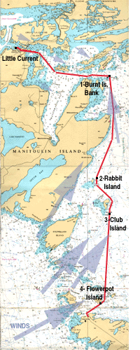
Trip Summary:  LITTLE CURRENT to TOBERMORY
   LEG   DPT   DESTINATION   ARV    MINS  MILES   MPH
    1    0800  Burnt Is.     0830    30    16     32.0
    2    0830  Rabbit Is.    0930    60    18     18.0
    3    0930  Club Is.      0950    20     6     18.0
    4    0950  Flowerpot Is. 1050    60    15     15.0
    5    1105  Tobermory     1115    10     3.5   21.0
    ____________________________________________________
    TOTALS and AVERAGES             180    58.5   19.5
Copyright © 1999, 2000 by James W. Hebert. Unauthorized reproduction prohibited!
This is a verified HTML 4.0 document served to you from continuousWave
URI: http://continuouswave.com
Last modified:
Author: James W. Hebert