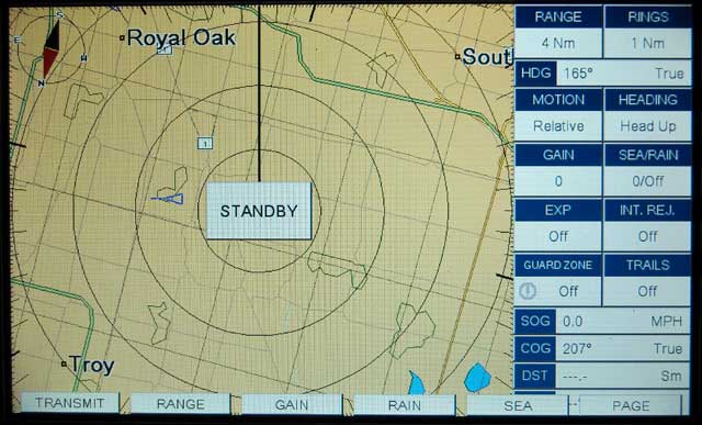
In the RADAR mode the function of the soft keys change to permit access to controls for the RADAR.
This article is a brief review and assessment of the Standard-Horizon CP300 combination GPS receiver and electronic chart display.
Standard-Horizon is best known for their VHF Marine Band radios, but they also market a line of GPS receivers and electronic chart plotters which use C-MAP cartography exclusively. These products have generally differentiated themselves from other brands by their strong integration with the ship's marine radio, and also as value leaders with a lot of features at a good price. The Standard Horizon CP300 is a GPS receiver and electronic chart display with a relatively large sunlight-viewable color display. The GPS receiver is housed in an external antenna assembly, but a model with an internal GPS receiver, the CP300i, is also available. With the addition of an optional sounder module, a SONAR can be added which shares the device's color display, creating a dual function device. In addition, the CP300 can also connect via NMEA-0183 to receivers for Digital Selective Calling (DSC) and the Automated Identification System (AIS), permitting the position of other vessels to be displayed. A RADAR system made by Sitex-Krogen can also be integrated to use the display.
The CP300 relies on an external GPS receiver, called a "GPS WAAS Smart Antenna." The term "Smart Antenna" is intended to distinguish it from passive antennas, as used on some other (generally older) GPS receivers with external antennas. The Smart Antenna enclosure appears to contain a complete GPS receiver, not just the antenna. The connecting cable contains only power or serial data wires, and not a coaxial cable for radio frequency signals, so it can be easily spliced. It's a self-contained device, getting only its power from the CP300 control head, and, in turn, supplying just data back to the control head. There are no GPS receiver electronics in the control head; everything is built into the Smart Antenna unit. The Smart Antenna has the familiar mushroom-shaped white plastic housing, and it provides the usual 1-inch x 14-TPI threaded coupling for mounting on a post. The coupling can be removed to permit the antenna to be mounted directly to a deck or other flat surface. The sensor is somewhat larger than a hockey puck, 97-mm in diameter and 32-mm thick.
The Standard Horizon WAAS GPS Smart Antenna has a very long, 15-meter permanently-attached cable which should allow the antenna to be located anywhere on a small boat. The end of the cable that runs to the control head has a moderately small connector. A hole of at least 3/4-inch diameter is required to pass the connector. The connector is a molded-on connector and it is not designed for field removal or re-installation. If you really wanted to avoid making a hole that large in a bulkhead through which the cable must pass, the instruction manual notes that you may cut and splice the cable.
The GPS receiver sensitivity is rated at -143 dBm, which should provide good reception even in low signal situations. I tested the unit by placing the antenna on a window sill of my home with a west exposure, a location where I have tested several other GPS receivers. The unit had been shipped from the west coast since its last power-up, and it took a few minutes for it to discover its new location in SE Michigan. The GPS receiver acquired and locked onto multiple satellites, even ones which had to be received through the roof and walls of my home. The receiver is able to track up to 16 satellites at once. Typically I saw it tracking six to eight satellites. A hot re-start produced a 3D-GPS fix within 10 seconds.
All GPS signal sources are identified by a code division multiple access modulation (CDMA) system which places a unique sub-carrier modulation on the course acquisition carrier of each signal. These modulation patterns are known as pseudo-random noise (PRN) codes, and for the primary orbiting GPS constellation there are a total of 32 codes available. Until just recently (February, 2008), the last PRN code, PRN 32, had not been in use since the very earliest deployment of the GPS. When PRN 32 was recently reactivated, some GPS receivers were not able to track it. The CP300 receiver is able to discover and track the satellite using PRN 32.
The CP300 says its GPS receiver is capable of using the following augmentation systems in various regions: Wide-Area Augmentation System or WAAS (North America), EGNOS (Europe) and MSAS (Asia). Of course, I could only test it with WAAS precision fixes.
WAAS signals come come from either ground stations or from satellites. The ground stations are intended for aviation users, and marine GPS receivers use the WAAS signals-in-space sources. Unlike the orbiting satellites of the rest of the GPS, WAAS signals-in-space are transmitted from geo-synchronous satellites whose position does not change. Since these WAAS signal sources remain in a fixed position, their location in the sky at any particular place in North America remains constant, that is, their azimuth and elevation (or "look angle") does not change. The initial deployment of WAAS used two signals from two satellites, however in July 2007 both of these original signals were shut off and two new signals replaced them. This changeover in WAAS signals has created the potential for some difficulties in WAAS reception.
Prior to July 2007 WAAS signals used PRN 122 and PRN 134. PRN 122 was transmitted from satellite AOR W at 142°W, which from Michigan gives a look angle low in the southwest. PR 134 was carried on satellite POR at 178°E, so from Michigan it has never been visible above the horizon and has never been useful.
After July 2007, WAAS signals shifted to two new satellites and two new PRN codes. PRN 135 is now an active WAAS signal-in-space source, carried on GALAXY 15 at 133°W and visible from Michigan at 240° azimuth and 20° elevation. A second WAAS source, PRN 138, is carried on ANIK F1R at 107.3°W. From Michigan its look angle is much better, 213° (south-southwest) and 35° elevation. Signals with higher elevation are naturally stronger as they have travelled less distance through space and the atmosphere to arrive.
For a GPS receiver with WAAS precision augmentation that is located in Michigan and looking for a signal, prior to July 2007 there was only one choice: PRN 122. After July 2007 both PRN 135 and PRN 138 are visible, but PRN 138 is generally preferred (in Michigan) due to greater signal strength. A GPS receiver has to acquire one of these WAAS signal sources and download the correction data being transmitted. The GPS receiver then has to utilize the information to enhance the precision of the fix it has deduced from the other orbiting satellites it is currently tracking. There is a lot of amazing science and calculation going on in this process. Even though we have become accustomed to fantastic performance from our electronics, it still takes a few minutes for an inexpensive GPS receiver to become operational with WAAS augmentation.
How a GPS receiver decides which WAAS PRN to use depends on its software and programming. Some receivers are hard-coded to look only for certain satellites, and thus after July 2007 they lost their WAAS augmentation due to the change in the signal sources available. Other receivers use automatic algorithms to hunt for a WAAS signal, beginning with a certain PRN code and then incrementing upward, looking for a signal that matches. This process can be lengthy if the hunt algorithm is not well designed. A series of images below demonstrate the performance of the CP300's GPS receiver and WAAS reception.
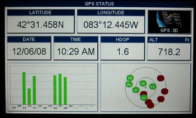
Within a few seconds of power-up from a cold start, the GPS receiver is tracking several satellites and has produced a three-dimension fix.
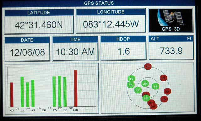
About one minute later the receiver has begun searching for the WAAS signal in space from PRN 138. Note those satellites visible but not received are to the east, and the walls and roof of my house are blocking them.
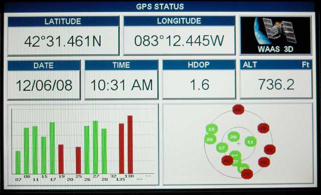
A moment later the receiver mode shifts to WAAS precision as noted by the change in the ICON at the upper right of the display. It has also found the signal from PRN 135. The height of the bars indicates signal strength. As expected, PRN 138 is stronger than PRN 135 due to the more favorable look angle.
The status bar for PRN 138 has turned green. This indicates the unit is using it to augment the precision of its deduced position fix. About three to four minutes have elapsed from the cold start.
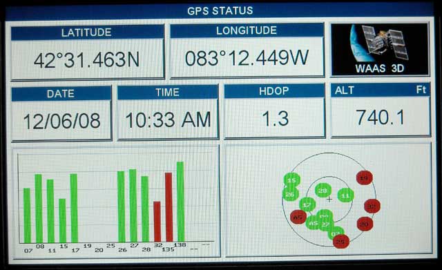
The above sequence of images shows the receiver's performance from a cold start, when it had been shut off for more than a week. The time to a complete WAAS precision fix mode was about three to four minutes, which represents a worst case. When re-booted (or a "hot" re-start) the receiver typically jumps to WAAS mode in less than two minutes.
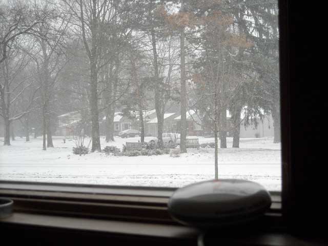
This test really was a "cold start" condition. Here is the view out the window to the southwest where the WAAS satellite's look angles lay. As you can see, the receiver has to look through falling snow and plenty of trees to receive the GPS signals in this location. When on an open cockpit boat there should be little difficulty with reception.
Although not explained in the manual, after some experimentation and random button pushing, I discovered a hidden GPS SETUP menu which controls some of the behavior of the GPS receiver. If while on the GPS STATUS page the ENT button is pushed, new sub-menus appear. These offer several choices:
In an earlier version of the software and using a different (and older) model of the Smart Antenna, the menu also allows the PRN number to be preset. Presetting the WAAS to a particular satellite makes a great deal of sense, as for each area of North America there is likely to be preferred satellite due to its look angle. This preset avoids having to waste a lot of time searching in the AUTO mode for satellites that are not available. The newer receiver model automatically selected and tracked the optimum WAAS source.
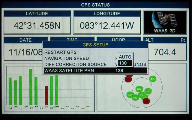
This hidden menu (from an older version) allows the WAAS augmentation to be preset to a particular source. For the eastern United States WAAS signal-in-space source PRN 138 is preferred.
As often happens with modern electronics, the printed manual lags the actual software in the device. Standard-Horizon plans to revise the printed manual for the CP300 to show this additional menu and other software changes since the initial printing.
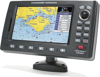
The CP300 display unit features a bright color thin film transistor liquid crystal display. The color display has 800 horizontal and 480 vertical pixels, measures 7-inches diagonally, and is rated as "splash-proof." There is a small joystick control which is used to control the cursor position on the chart displays. The joystick also plays a major role in the user interface to the device's menu selections and other user input choices.
The size of the display is the principle feature of any chart plotter. The 7-inch screen of the CP300 is very nice, larger than most other units in this price range, and the pixel resolution is excellent. With 384,000 pixels the presentation is very fine and no pixilation is evident. On power-up the unit shows a high-resolution color photograph and graphic, which gives a hint of how video will look when viewed on the display via an external video input connector. I did not get a chance to test the display on a boat and in direct sunlight, however with the late afternoon sun coming through the windows, the display was still easily visible. With indirect lighting, I had to turn down the display backlight and contrast controls to prevent it from being too bright to comfortably view.
The joystick control is located at the top right corner of the unit. Standard-Horizon refers to this as a ShuttlePoint knob. It is easy to operate for right-handed people because the palm of the right hand can rest on the right side of the housing and the thumb can be used to manipulate the control. Operating the joystick control with the left hand is more awkward. Immediately below the joystick are the ENT (enter) and CLR (clear or escape) buttons, which will be frequently used in operating the device. Again, for a right-handed operator these buttons will be very conveniently located and can be tapped with the thumb. Below the ENT and CLR buttons are six more buttons. The MENU button is the most used of these. The MENU button invokes a page offering a choice of twelve other pages, including access to the SET UP menu. Above the ShuttlePoint knob are the ZOOM IN and ZOOM OUT buttons, which are used just about exclusively for sizing the chart display region.
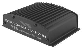
The CP300 can be connected to the optional FF520 black box SONAR module. I did not have the FF520 available for testing. The unit does not claim to be a "digital" SONAR. Its specification state a power output of 500 or 1,000-watts and dual frequency operation at either 50-kHz or 200-kHz.
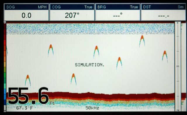
This simulated display shows the color SONAR raster presentation of received echoes. Color corresponds to signal amplitude. At the far left there is a vertical legend showing the color hierarchy. Water depth and temperature are also shown. An "A-Scope" display is at the far right.
A variety of transducer options are available for the FF520. The transducers appear to be private-label versions of the AIRMAR transducers. These are generally very high quality transducers and give excellent performance. The FF520 can make use of the Transducer ID feature to automatically adapt its frequency and power to the connected transducer.
My first impression of the CP300 was made by hooking up its power cord. The power cord is constructed from flexible multi-conductor cable. Unlike some other brands, the insulation is supple and not stiff. The conductor wire size is just right, not so big you feel like you're connecting a space heater and not so small you feel like you're doing micro-surgery. The main unit has no integral cords, so you can easily remove it from the boat if desired by disconnecting the several connectors (e.g. power/data and antenna). The connectors are all molded-on connectors and use a bayonet-style twist locking collar.
Turning the CP300 on for the first time I was pleasantly surprised by the color "splash screen" that announces the device is working. The splash screen is a detailed high resolution image that shows you the full capabilities of this display.
As usual, I approached operation of the CP300 without reading the instruction manual. I wanted to see if I could deduce the layout of controls and functions just by interacting with them. Since I have been using another Standard-Horizon GPSr and Chart Plotter, a CP-150, I assumed there would be some carry over to the user interface. And there was.
The unit has 18 front panel controls. Twelve of these are fixed controls, while six are "soft" keys, that is, a button whose function can change depending on which screen is being displayed and whose label is shown above it in the display. Curiously, there did not appear to be any labels for the soft keys showing in the display. I had to consult the manual for the explanation. The CP300 uses a unique approach to the soft key labels. Rather than continually steal screen space for the soft key labels, the labels are not shown on the display until a soft key is pressed. To invoke the soft key labels, you just press one of the six soft key buttons. The labels then appear across the bottom of the screen, above the keys themselves. Then you can press the desired key. Even if you know the desired key already, you have to press it twice. The first press invokes the label; the second press initiates the function. The soft key functionality on the CP300 in the chart plotter seems limited only to selection of the page to be displayed. The six keys always allow the user to jump to any one of six preset pages, much like a station preset button on an old car radio. Also, the soft keys can be custom programed to the user's choice of destination page.
When optional devices such as the RADAR or SONAR are added, additional, new pages become available, and on these non-chart plotter pages the soft keys are used for new functions. Overall the user input for menu choice selection is accomplished by a combination of soft key selection or by use of the ShuttlePoint knob. On some pages if a soft key is pushed the soft key buttons and labels also appear along with the page's own menu boxes, creating a confusing presentation of multiple buttons.
Intelligent use of soft keys eliminates having to navigate through hierarchical menus to make selections and choices. When soft keys are used consistently as the primary user input device, the user does not have to shift from the soft key area of the device to the fixed key area when making selections. On the CP300 chart plotter the six extra front panel buttons are not utilized as well as they might be if the software was re-written to consistently employ them for all menu selections. My impression is the same basic hardware and software in the CP300 are also used in the smaller CP-180, a unit which lacks the six extra front panel buttons. This impression is gained from the owner's manual, which is written as a common publication for both units. Based on the somewhat limited use of the six extra front panel buttons of the CP300, I suspect that the operating system of the CP300 was not completely developed with those buttons in mind. Instead, the basic operating system of the CP300 is that of the CP180, which lacks the six buttons. This prevents those buttons from being fully integrated into the user interface of the CP300, and gives them less functionality. The soft keys and the ShuttlePoint Knob share the task of providing input and navigation to the CP300's user interface. The soft keys are nice to have, but it would have been nicer if greater use of them was made in the user interface.
The soft keys do provide additional functions when the display is shifted to the SONAR or RADAR modes. When using those accessories, the soft-keys change function from screen to screen and provide some of the control input for make changes or adjustments.
In the RADAR mode the function of the soft keys change to permit access to controls for the RADAR.
An overwhelmingly important element of any electronic chart display is the chart cartography. The CP300 is not bundled with any detailed cartography, but it does include a United States base chart for coastal areas and the Great Lakes. The base map has plenty of land details, like the names of even small municipalities and most major roads, but it fails to show much marine information. Only the most prominent navigation aids are shown, and very little sounding data. The base map would only be suitable for the very coarsest of navigation. Users will universally need to purchase additional cartography to provide useful chart information for navigation.
More detailed digital cartography is provided by a C-MAP chart card which is inserted into a single front panel slot located behind a covering door with latch. According to the instruction manual, the CP300 can work with either C-MAP NT+ chart cards or with the newer C-MAP MAX chart cards. I only had two chart card on hand, both C-MAP NT+ volumes. It was interesting to see the cartography on these cards presented in color, as previously I had used them only with a black and white display.
The presence of enhanced cartography display in the CP300 (and likely in other C-MAP based plotters) depends greatly on the zoom level being shown. In some instances the enhanced cartography is not utilized until the display is zoomed in to a certain minimum level. When this level of zoom is reached, the display suddenly transforms from very crude detail to very high detail. Apparently the mechanism or algorithm used to created the on-screen images is not able to interpolate or extrapolate the high-resolution cartography when at certain zoom settings. The sequence of screen shots below shows this situation.
With the ZOOM set too wide, the display loses important elements of the cartography. The border drawn around the area near the top is a cue that more detail is available in that region. Note that no soundings are shown at this level.
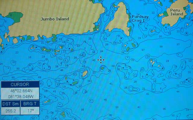
Increasing the ZOOM level one layer reveals a fantastic improvement in detail. If the user is not aware of this quirk, this enhanced detail might not be noticed. Soundings and depth contour lines suddenly appear.
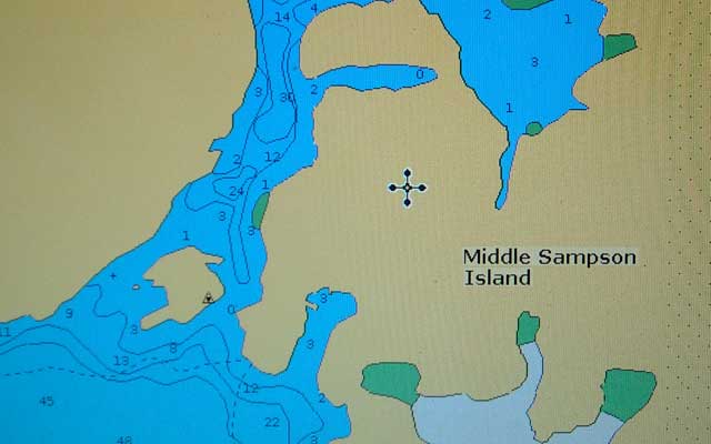
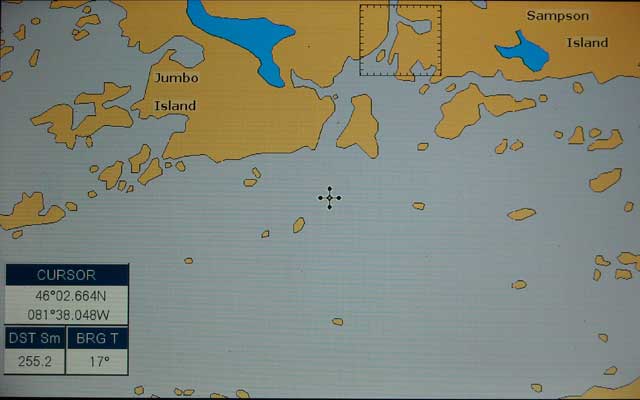
The C-MAP NT+ card provides excellent detail, here showing a tight passage on the way to Iroquois Bay in northern Lake Huron.
The CP300 does not provide any mechanism for grabbing an image of its screen display and writing it to a storage volume. While this is not particularly important to some users, it can be highly useful in preserving a record of interesting SONAR displays. The unit does have a peculiar connector on its front panel (hidden under the door of the C-MAP Card compartment) which apparently allows for connecting to it via perhaps a USB link. Use of this connector seems to be limited to the factory. I suspect that is how they obtain the screen shots used in their publications.
The screen images shown here were taken with a camera with a digital sensor, and, as you can see, there are occasional cases of a moiré pattern formed from the interference of the scan lines. When viewed with your eye, the display is very crisp and clear and does not have any moiré pattern.
The CP300 has very extensive NMEA-0183 serial data transmit and receive capability. It has five NMEA-0183 outputs and four NMEA-0183 inputs. A fifth NMEA-0183 input (PORT 3) is dedicated to receiving data from the GPS WAAS Smart Antenna. If the FF520 Sounder is connected, it uses one input and one output (PORT 2), but this still leaves four outputs and three inputs. If the RADAR is connected, it also uses an input-output pair. In most small boat installations there should be no problem interfacing this display to other NMEA-0183 devices.
PORT 1 of the NMEA-0183 interface will generally be used to connect to a VHF Marine Band radio for exchange of digital selective calling (DSC) information. The CP300 will provide position data to the radio to be transmitted, either as part of a distress message or in reply to requests for the vessel's current position from other DSC callers. The radio will provide position data received from other vessels to be displayed on the CP300. Standard-Horizon pioneered this technique, and its chart plotters respond to input of the NMEA sentences DSC and DSE by placing a mark on the chart display, as well as offering the option of navigating to the mark using the GO TO function.
There is a menu option in the ADVANCED SETTINGS tree which for each (of the five) NMEA output allows the the selection of which sentences will be sent. The available sentences for output are:
The sentences recognized when input are:
The CP300 also provides a NMEA DATA screen which can be set to show the raw data being received on any of its five input ports. This can be very useful in diagnosing problems with serial data connections between devices.
The CP300 is a true multi-function device. In addition to is its own vessels's position plotted on the electronic chart displays, the CP300 can display the position of remote vessels from data received via a DSC remote position poll transmission from a connected VHF Marine Band radio with DSC capability. The CP300 can also display other vessel positions received by an connected AIS receiver. To receive NMEA data from an AIS receiver, the NMEA port serial data speed must be changed to 38,400 BPS. AIS data is transmitted at a higher speed in order to increase the update rate for rapidly moving target vessels.
The CP300 can display up to 100 vessel positions as received by an AIS receiver. By moving the cursor over a target icon, the following information will be displayed:
The CP300 is claimed to be the only device in its price range which computes the closest point of approach (CPA) of AIS target vessels.
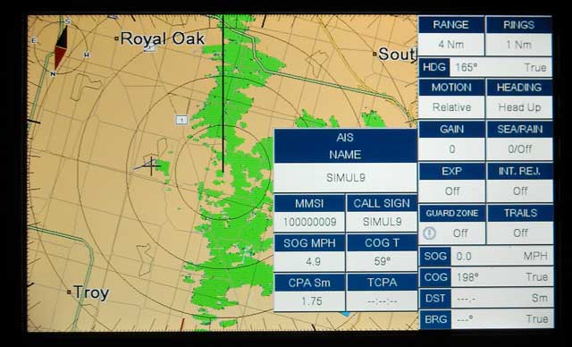
This screen shows both the RADAR and AIS Target Information from a simulator mode. The cursor has been placed over an AIS target to produce the pop-up window with additional information. The display is also overlaying the RADAR plan position indicator over the digital chart. The mode has been chosen to be heading-up.
The CP300 can also display the plan position indicator display of an attached RADAR device. Compatible RADAR units are the Sitex-Koden models MDS-1, MDS-8, MDS-9, MDS-10-4, and MDS-10-5. More information on RADAR accessories is available in an owner's manual supplement from Standard-Horizon. You may need to apply a software update using the C-CARD slot. Connecting the RADAR uses both the input and output of PORT 1 of the NMEA serial interface.
The CP300 serial interface also supports connection of a C-COM modem, a GSM communication system to be purchased separately. The C-COM modem communicates with the C-MAP weather server and provides weather data and forecast information. This system does not appear to be in popular use in North America among recreational boaters.
Most marine electronics are sold at a substantial discount from their retail price. Price comparisons have to be based on actual selling prices, not on inflated MSRP's. Another difficulty in price comparison is the wide variation among various manufacturers in the exactly what is included in the bundled product. In the case of the CP300, here's what is in the box:
The full retail list price for the CP300 is $1,400. The CP300 is currently selling between $700 to $900 at discount from marine electronics sellers. In addition, most users will need to purchase a C-MAP Chart card for their area of interest. The least expensive chart cards sell for $100. If SONAR operation is desired, the FF520 sounder module (about $225) and an appropriate transducer (about $125) will have to be purchased, adding about $350 to the cost. To build up a full GPSr, chart plotter, SONAR, transducer, and at least one chart data card the approximate price will be in the range of $1,150 to $1,350 at the discounted prices available. A sales incentive was recently offered which included a free $99 C-MAP chart card of your choice.
The CP300 is provided with a GPS receiver that has good performance and has automatic WAAS operation. The newer model of GPS Smart Antenna has improved performance compared to older models previously supplied with the CP300.
The display resolution is excellent and the display size is very good. In many instances units with a larger physical display do not have more pixels. The display is capable of being used with multiple devices. Since the display is the most prominent and most expensive component in most vessel electronic devices, it is smart to make use of this large display for as many functions as possible.
The CP300 has excellent NMEA interface capabilities, and it is state-of-the-art in its ability to interface with Digital Selective Calling receivers and with Automatic Identification System receivers.
The user interface of the operating system is somewhat inconsistent in its use of the six extra front panel buttons on the device. The operating system could be re-written to take greater advantage of those buttons on the models which offer them.
The C-MAP digital cartography is somewhat sensitive to the ZOOM level being used, and if the ZOOM is not properly set, available detail may be lost. A smoother transition between ZOOM levels would be more beneficial for the user. C-MAP cartography is available on a world-wide basis, which distinguishes it from some other brands of cartography which are mainly concentrated on North America.
Many thanks to Jason Kennedy at Standard-Horizon for providing the CP300 used in this evaluation.
There is a thread with further discussion of the Standard-Horizon CP300 in the SMALL BOAT ELECTRICAL discussion.
DISCLAIMER: This information is believed to be accurate but there is no guarantee. We do our best!
The page has been accessed times.
Copyright © 2008 by James W. Hebert. Unauthorized reproduction prohibited!
This is a verified HTML 4.0 document served to you from continuousWave
URI: http://continuouswave.com
Last modified:
Author: James W. Hebert
This article first appeared December 6, 2008.